Property Record
8555 Manderville Ln, Dallas, TX 75231

Save to a Folder
{{folder.Name}}
{{folder.ListingIds.length}} Properties
{{folder.ListingIds.length}} Property
Create a New Folder
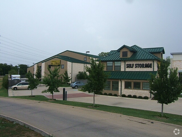
Property Detail
8555 Manderville Ln
007290000002A0000
ROYAL/MANDERVILLE BLK 7290 LT 2A ACS 1.638 INT200600230669 DD06222006 CO-DC 7290 000 02A00 3DA7290 000
Warehouse
DALLAS
Z96
Texas
AE The base floodplain where base flood elevations are provided. AE Zones are now used on new format FIRMs instead of A1-A30 Zones.
2a
2025
1.64 AC
2025
Central Expressway
007823
Dallas/Ft Worth
84,508 SF
Dallas-Fort Worth-Arlington, TX
NEARBY LISTINGS FOR SALE OR LEASE
DEMOGRAPHICS near 8555 Manderville Ln
1 mile
3 mile
5 mile
2025 Total Population
18,193
165,624
414,885
2030 Population
18,934
171,477
428,057
Pop Growth 2025-2030
+ 4.07%
+ 3.53%
+ 3.17%
Average Age
40
38
38
2025 Total Households
9,763
74,315
176,011
HH Growth 2025-2030
+ 4.12%
+ 3.61%
+ 3.30%
Median Household Inc
$75,535
$70,261
$82,471
Avg Household Size
1.80
2.20
2.30
2025 Avg HH Vehicles
1.00
1.00
2.00
Median Home Value
$554,501
$732,211
$660,329
Median Year Built
1979
1980
1978
Nearby Places
Map Layers
Map Styles
 Street
 Aerial
Layers
 Traffic
 Biking
Places
Listings with unknown addresses are not visible on the map
- Restaurants
- Banks
- Shops
- Fitness
- Groceries
PUBLIC TRANSPORTATION
COMMUTER RAIL
Victory Station (TRINITY RAILWAY - DALLAS AREA RAPID TRANSIT)
Drive
Walk
Distance
Victory Station (TRINITY RAILWAY - DALLAS AREA RAPID TRANSIT)
13 min
9.3 mi
AIRPORT
Dallas Love Field
Drive
Walk
Distance
Dallas Love Field
18 min
9.3 mi
Dallas-Fort Worth International
Drive
Walk
Distance
Dallas-Fort Worth International
29 min
23.2 mi
Freight Ports
Port of Shreveport
Drive
Walk
Distance
Port of Shreveport
216 min
198.5 mi
Nearby Properties
Address
Land Use
TOTAL SIZE
Lot Size
Zoning
Address
Land Use
TOTAL SIZE
Lot Size
Zoning
4,157,377 SF
76.79 AC
Z248
Address
Land Use
TOTAL SIZE
Lot Size
Zoning
7,706,477 SF
245.55 AC
Z116
Address
Land Use
TOTAL SIZE
Lot Size
Zoning
2,186,362 SF
48.27 AC
Z239
Address
Land Use
TOTAL SIZE
Lot Size
Zoning
502,529 SF
3.08 AC
Z239
Address
Land Use
TOTAL SIZE
Lot Size
Zoning
1,252,860 SF
57.08 AC
Z239
Address
Land Use
TOTAL SIZE
Lot Size
Zoning
3,423,779 SF
32.42 AC
Z151
Address
Land Use
TOTAL SIZE
Lot Size
Zoning
77.76 AC
Z239
Address
Land Use
TOTAL SIZE
Lot Size
Zoning
1,086,919 SF
5.85 AC
Z239
Address
Land Use
TOTAL SIZE
Lot Size
Zoning
557,392 SF
10.06 AC
Z239
Address
Land Use
TOTAL SIZE
Lot Size
Zoning
395,377 SF
14.61 AC
Z163
Address
Land Use
TOTAL SIZE
Lot Size
Zoning
835,301 SF
9.29 AC
Z239
Address
Land Use
TOTAL SIZE
Lot Size
Zoning
674,474 SF
18.81 AC
Z164
Address
Land Use
TOTAL SIZE
Lot Size
Zoning
776,707 SF
8.47 AC
Address
Land Use
TOTAL SIZE
Lot Size
Zoning
421,798 SF
9 AC
Z151
Address
Land Use
TOTAL SIZE
Lot Size
Zoning
540,436 SF
1.86 AC
Z239
Address
Land Use
TOTAL SIZE
Lot Size
Zoning
852,562 SF
13.86 AC
Z151
Address
Land Use
TOTAL SIZE
Lot Size
Zoning
399,256 SF
13.19 AC
Z164
Address
Land Use
TOTAL SIZE
Lot Size
Zoning
184,388 SF
18.89 AC
Z298
Address
Land Use
TOTAL SIZE
Lot Size
Zoning
485,067 SF
14.87 AC
Z239
Address
Land Use
TOTAL SIZE
Lot Size
Zoning
611,288 SF
8.80 AC
Z163
Address
Land Use
TOTAL SIZE
Lot Size
Zoning
462,916 SF
15.67 AC
Z248
Address
Land Use
TOTAL SIZE
Lot Size
Zoning
249,692 SF
244.62 AC
Z239
Address
Land Use
TOTAL SIZE
Lot Size
Zoning
1,009,203 SF
33.32 AC
Z125
Address
Land Use
TOTAL SIZE
Lot Size
Zoning
302,553 SF
15.59 AC
Z164
Address
Land Use
TOTAL SIZE
Lot Size
Zoning
403,339 SF
16.42 AC
Z239
Address
Land Use
TOTAL SIZE
Lot Size
Zoning
379,592 SF
12.75 AC
Z248
Address
Land Use
TOTAL SIZE
Lot Size
Zoning
592,314 SF
4.19 AC
Z96
Address
Land Use
TOTAL SIZE
Lot Size
Zoning
819,202 SF
15.47 AC
Z163
Address
Land Use
TOTAL SIZE
Lot Size
Zoning
456,300 SF
10.92 AC
Z239
Address
Land Use
TOTAL SIZE
Lot Size
Zoning
573,575 SF
6.43 AC
Z239
The World's #1 Commercial Real Estate Marketplace
Connect with us
© 2026 CoStar Group
The information above has been obtained from sources believed reliable. While we do not doubt its accuracy we have not verified it and make no guarantee, warranty or representation about it. It is your responsibility to independently confirm its accuracy and completeness. Any projections, opinions, assumptions, or estimates used are for example only and do not represent the current or future performance of the property. The value of this transaction to you depends on tax and other factors which should be evaluated by your tax, financial, and legal advisors. You and your advisors should conduct a careful, independent investigation of the property to determine to your satisfaction the suitability of the property for your needs.