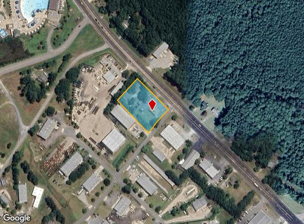
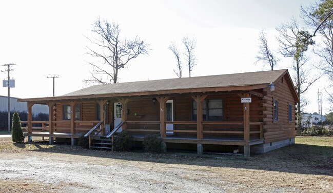
Property Record
8556 Caratoke Hwy, Powells Point, NC 27966

NEARBY LISTINGS FOR SALE OR LEASE
Property Detail
8556 Caratoke Hwy
0124-000-0125-0000
SMITH
Realpropertynec
Currituck
X
North Carolina
3720983700K
125
2025
1.23 AC
2025
Currituck County
110404
Hampton Roads
2,238 SF
Virginia Beach-Norfolk-Newport News, VA-NC
DEMOGRAPHICS near 8556 Caratoke Hwy
1 Mile
3 Mile
5 Mile
2024 Total Population
422
2,916
4,986
2029 Population
531
3,683
6,039
Pop Growth 2024-2029
+ 25.83%
+ 26.30%
+ 21.12%
Average Age
44
43
45
2024 Total Households
172
1,169
2,019
HH Growth 2024-2029
+ 26.16%
+ 26.26%
+ 20.95%
Median Household Inc
$67,894
$73,255
$84,729
Avg Household Size
2.50
2.50
2.50
2024 Avg HH Vehicles
2.00
3.00
2.00
Median Home Value
$274,999
$284,299
$350,558
Median Year Built
1995
1996
1995
Nearby Places
Map Layers
Map Styles
 Street
 Aerial
- Restaurants
- Banks
- Shops
- Fitness
- Groceries
Nearby Properties
Address
Land Use
TOTAL SIZE
Lot Size
Zoning
Address
Land Use
TOTAL SIZE
Lot Size
Zoning
2,352 SF
96.77 AC
HI
Address
Land Use
TOTAL SIZE
Lot Size
Zoning
24,000 SF
12.94 AC
GB
Address
Land Use
TOTAL SIZE
Lot Size
Zoning
15,600 SF
9.84 AC
GB
Address
Land Use
TOTAL SIZE
Lot Size
Zoning
6,688 SF
18.43 AC
GB
Address
Land Use
TOTAL SIZE
Lot Size
Zoning
1,408 SF
7.87 AC
GB
Address
Land Use
TOTAL SIZE
Lot Size
Zoning
37 AC
GB
Address
Land Use
TOTAL SIZE
Lot Size
Zoning
9,683 SF
151 AC
GB
Address
Land Use
TOTAL SIZE
Lot Size
Zoning
248.24 AC
HI
Address
Land Use
TOTAL SIZE
Lot Size
Zoning
4,008 SF
1.96 AC
Address
Land Use
TOTAL SIZE
Lot Size
Zoning
8,631 SF
10.50 AC
GB
Address
Land Use
TOTAL SIZE
Lot Size
Zoning
900 SF
5.39 AC
GB
Address
Land Use
TOTAL SIZE
Lot Size
Zoning
6,695 SF
194.68 AC
SFM
Address
Land Use
TOTAL SIZE
Lot Size
Zoning
15,168 SF
1.93 AC
LI
Address
Land Use
TOTAL SIZE
Lot Size
Zoning
1,056 SF
5.28 AC
AG
Address
Land Use
TOTAL SIZE
Lot Size
Zoning
876 SF
100.77 AC
GB
Address
Land Use
TOTAL SIZE
Lot Size
Zoning
24.57 AC
SFM
Address
Land Use
TOTAL SIZE
Lot Size
Zoning
56.60 AC
GB
Address
Land Use
TOTAL SIZE
Lot Size
Zoning
3,000 SF
2.54 AC
PD-M
Address
Land Use
TOTAL SIZE
Lot Size
Zoning
512 SF
437 AC
GB
Address
Land Use
TOTAL SIZE
Lot Size
Zoning
16,135 SF
3.27 AC
GB
Address
Land Use
TOTAL SIZE
Lot Size
Zoning
3,972 SF
4 AC
SFM
Address
Land Use
TOTAL SIZE
Lot Size
Zoning
3,190 SF
5.30 AC
LI
Address
Land Use
TOTAL SIZE
Lot Size
Zoning
5,788 SF
14.86 AC
Address
Land Use
TOTAL SIZE
Lot Size
Zoning
3,694 SF
25.11 AC
AG
Address
Land Use
TOTAL SIZE
Lot Size
Zoning
4,099 SF
1.27 AC
SFM
Address
Land Use
TOTAL SIZE
Lot Size
Zoning
3,758 SF
20.69 AC
AG
Address
Land Use
TOTAL SIZE
Lot Size
Zoning
3,640 SF
1.28 AC
GB
Address
Land Use
TOTAL SIZE
Lot Size
Zoning
9,046 SF
4.04 AC
GB
Address
Land Use
TOTAL SIZE
Lot Size
Zoning
5,359 SF
0.82 AC
SFM
Address
Land Use
TOTAL SIZE
Lot Size
Zoning
5,565 SF
0.69 AC
SFM
The World's #1 Commercial Real Estate Marketplace
Connect with us
© 2025 CoStar Group
The information above has been obtained from sources believed reliable. While we do not doubt its accuracy we have not verified it and make no guarantee, warranty or representation about it. It is your responsibility to independently confirm its accuracy and completeness. Any projections, opinions, assumptions, or estimates used are for example only and do not represent the current or future performance of the property. The value of this transaction to you depends on tax and other factors which should be evaluated by your tax, financial, and legal advisors. You and your advisors should conduct a careful, independent investigation of the property to determine to your satisfaction the suitability of the property for your needs.