Property Record
8560 E Elliot Rd, Mesa, AZ 85212
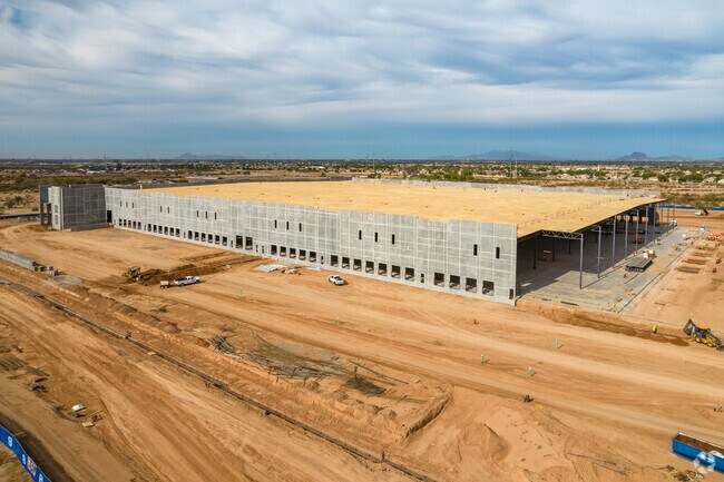

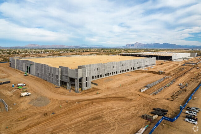

Property Detail
8560 E Elliot Rd
Phoenix-Mesa-Chandler, AZ
E202 MCR 1648-01
304-03-982
MARICOPA
Warehouse
Arizona
2025
1
2025
71.41 AC
817600
Chandler N/Gilbert
1,195,173 SF
Phoenix
NEARBY LISTINGS FOR SALE OR LEASE
DEMOGRAPHICS near 8560 E Elliot Rd
1 mile
3 mile
5 mile
2025 Total Population
7,711
76,118
239,238
2030 Population
8,306
79,833
251,508
Pop Growth 2025-2030
+ 7.72%
+ 4.88%
+ 5.13%
Average Age
35
39
40
2025 Total Households
2,430
26,708
86,571
HH Growth 2025-2030
+ 7.45%
+ 4.76%
+ 5.27%
Median Household Inc
$92,979
$99,789
$94,794
Avg Household Size
3.00
2.80
2.70
2025 Avg HH Vehicles
2.00
2.00
2.00
Median Home Value
$450,483
$477,136
$465,056
Median Year Built
2003
2001
2001
Nearby Places
Map Layers
Map Styles
 Street
 Aerial
Transit
 Traffic
 Biking
Places
Listings with unknown addresses are not visible on the map
- Restaurants
- Banks
- Shops
- Fitness
- Groceries
PUBLIC TRANSPORTATION
AIRPORT
Phoenix-Mesa Gateway
Drive
Walk
Distance
Phoenix-Mesa Gateway
14 min
6.7 mi
Phoenix Sky Harbor International
Drive
Walk
Distance
Phoenix Sky Harbor International
40 min
26.9 mi
SALE & LEASE HISTORY
LISTING DATE
SALE/LEASE

Apr 20, 2021
For Lease
Nearby Properties
Address
Land Use
TOTAL SIZE
Lot Size
Zoning
Address
Land Use
TOTAL SIZE
Lot Size
Zoning
184.86 AC
Address
Land Use
TOTAL SIZE
Lot Size
Zoning
108,297 SF
102.46 AC
PS
Address
Land Use
TOTAL SIZE
Lot Size
Zoning
93.03 AC
Address
Land Use
TOTAL SIZE
Lot Size
Zoning
484,906 SF
199.48 AC
Address
Land Use
TOTAL SIZE
Lot Size
Zoning
16.38 AC
Address
Land Use
TOTAL SIZE
Lot Size
Zoning
1,355,382 SF
83.17 AC
PAD
Address
Land Use
TOTAL SIZE
Lot Size
Zoning
467,727 SF
104.86 AC
AG
Address
Land Use
TOTAL SIZE
Lot Size
Zoning
403,171 SF
34.53 AC
PF
Address
Land Use
TOTAL SIZE
Lot Size
Zoning
454,704 SF
101.68 AC
AG
Address
Land Use
TOTAL SIZE
Lot Size
Zoning
580,492 SF
41.81 AC
R3
Address
Land Use
TOTAL SIZE
Lot Size
Zoning
615,202 SF
35.88 AC
AG
Address
Land Use
TOTAL SIZE
Lot Size
Zoning
524,905 SF
40.33 AC
Address
Land Use
TOTAL SIZE
Lot Size
Zoning
15.78 AC
Address
Land Use
TOTAL SIZE
Lot Size
Zoning
18.36 AC
Address
Land Use
TOTAL SIZE
Lot Size
Zoning
200,976 SF
25.04 AC
PC
Address
Land Use
TOTAL SIZE
Lot Size
Zoning
4.60 AC
C-C
Address
Land Use
TOTAL SIZE
Lot Size
Zoning
12.99 AC
Address
Land Use
TOTAL SIZE
Lot Size
Zoning
449,435 SF
26.87 AC
LI
Address
Land Use
TOTAL SIZE
Lot Size
Zoning
390,917 SF
15.82 AC
RM4
Address
Land Use
TOTAL SIZE
Lot Size
Zoning
779,546 SF
53.20 AC
LI
Address
Land Use
TOTAL SIZE
Lot Size
Zoning
965,386 SF
60.57 AC
Address
Land Use
TOTAL SIZE
Lot Size
Zoning
94,701 SF
7.89 AC
LC
Address
Land Use
TOTAL SIZE
Lot Size
Zoning
4.77 AC
LC
Address
Land Use
TOTAL SIZE
Lot Size
Zoning
14.77 AC
I-1
Address
Land Use
TOTAL SIZE
Lot Size
Zoning
281,929 SF
12.07 AC
Address
Land Use
TOTAL SIZE
Lot Size
Zoning
152,549 SF
60 AC
PC
Address
Land Use
TOTAL SIZE
Lot Size
Zoning
292,665 SF
15.26 AC
PC
Address
Land Use
TOTAL SIZE
Lot Size
Zoning
3.03 AC
C-C
The World's #1 Commercial Real Estate Marketplace
Connect with us
© 2026 CoStar Group
The information above has been obtained from sources believed reliable. While we do not doubt its accuracy we have not verified it and make no guarantee, warranty or representation about it. It is your responsibility to independently confirm its accuracy and completeness. Any projections, opinions, assumptions, or estimates used are for example only and do not represent the current or future performance of the property. The value of this transaction to you depends on tax and other factors which should be evaluated by your tax, financial, and legal advisors. You and your advisors should conduct a careful, independent investigation of the property to determine to your satisfaction the suitability of the property for your needs.