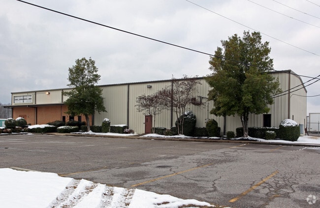
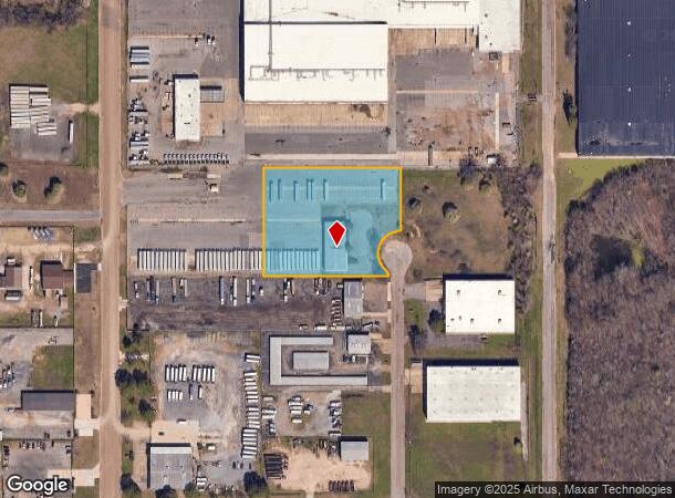
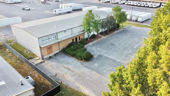
Property Record
8561 Aaron Ln, Southaven, MS 38671
NEARBY LISTINGS FOR SALE OR LEASE
Property Detail
8561 Aaron Ln
Memphis, TN-MS-AR
Industrial Park Sd
1085220200005800
FREEPORT INDUSTRIAL PARK SD U LOT 58
Commercialnec
DeSoto
X
Mississippi
47157C0560F
58
2025
2.70 AC
2025
DeSoto
070421
Memphis
10,140 SF
DEMOGRAPHICS near 8561 Aaron Ln
1 Mile
3 Mile
5 Mile
2024 Total Population
2,356
57,873
136,485
2029 Population
2,604
60,548
142,074
Pop Growth 2024-2029
+ 10.53%
+ 4.62%
+ 4.09%
Average Age
37
38
38
2024 Total Households
944
21,416
52,029
HH Growth 2024-2029
+ 10.59%
+ 4.63%
+ 4.14%
Median Household Inc
$44,999
$45,831
$45,208
Avg Household Size
2.50
2.60
2.60
2024 Avg HH Vehicles
2.00
2.00
2.00
Median Home Value
$127,814
$119,619
$124,997
Median Year Built
1975
1976
1975
Nearby Places
Map Layers
Map Styles
 Street
 Aerial
- Restaurants
- Banks
- Shops
- Fitness
- Groceries
PUBLIC TRANSPORTATION
AIRPORT
Memphis International
DRIVE
WALK
Distance
Memphis International
17 min
9.1 mi
SALE & LEASE HISTORY
LISTING DATE
SALE/LEASE

Nov 17, 2023
For Sale
Aug 21, 2023
For Sale
Nearby Properties
Address
Land Use
TOTAL SIZE
Lot Size
Zoning
Address
Land Use
TOTAL SIZE
Lot Size
Zoning
1,009,363 SF
78.56 AC
EMP
Address
Land Use
TOTAL SIZE
Lot Size
Zoning
1,021,440 SF
57.67 AC
M-1
Address
Land Use
TOTAL SIZE
Lot Size
Zoning
810,225 SF
47.71 AC
M-1
Address
Land Use
TOTAL SIZE
Lot Size
Zoning
188,404 SF
59.17 AC
R-8
Address
Land Use
TOTAL SIZE
Lot Size
Zoning
230,103 SF
22.07 AC
CMU-2
Address
Land Use
TOTAL SIZE
Lot Size
Zoning
79,658 SF
7 AC
RU-3
Address
Land Use
TOTAL SIZE
Lot Size
Zoning
79,340 SF
7 AC
RU-3
Address
Land Use
TOTAL SIZE
Lot Size
Zoning
619,021 SF
28.71 AC
PBP
Address
Land Use
TOTAL SIZE
Lot Size
Zoning
601,700 SF
29.51 AC
PBP
Address
Land Use
TOTAL SIZE
Lot Size
Zoning
37,631 SF
3.39 AC
CMU-2
Address
Land Use
TOTAL SIZE
Lot Size
Zoning
408,580 SF
31.28 AC
M-1
Address
Land Use
TOTAL SIZE
Lot Size
Zoning
111,541 SF
8.88 AC
R-8
Address
Land Use
TOTAL SIZE
Lot Size
Zoning
23,416 SF
5.81 AC
RU-3
Address
Land Use
TOTAL SIZE
Lot Size
Zoning
554,433 SF
24.57 AC
PBP
Address
Land Use
TOTAL SIZE
Lot Size
Zoning
18,228 SF
6.17 AC
CMU-1
Address
Land Use
TOTAL SIZE
Lot Size
Zoning
11,937 SF
18.14 AC
PUD
Address
Land Use
TOTAL SIZE
Lot Size
Zoning
167,607 SF
5.52 AC
CMU-2
Address
Land Use
TOTAL SIZE
Lot Size
Zoning
48,171 SF
6.97 AC
R-10
Address
Land Use
TOTAL SIZE
Lot Size
Zoning
12,775 SF
26.29 AC
PUD
Address
Land Use
TOTAL SIZE
Lot Size
Zoning
432,771 SF
21.84 AC
PBP
Address
Land Use
TOTAL SIZE
Lot Size
Zoning
74,717 SF
4.74 AC
RU-3
Address
Land Use
TOTAL SIZE
Lot Size
Zoning
186,757 SF
29 AC
C-4
Address
Land Use
TOTAL SIZE
Lot Size
Zoning
32,760 SF
2.09 AC
CMU-2
Address
Land Use
TOTAL SIZE
Lot Size
Zoning
59,264 SF
7.28 AC
RU-3
Address
Land Use
TOTAL SIZE
Lot Size
Zoning
9,684 SF
13.06 AC
R-6
Address
Land Use
TOTAL SIZE
Lot Size
Zoning
499,200 SF
24.82 AC
M-1
Address
Land Use
TOTAL SIZE
Lot Size
Zoning
150,694 SF
29 AC
M-1
Address
Land Use
TOTAL SIZE
Lot Size
Zoning
10,160 SF
10 AC
RM-6
Address
Land Use
TOTAL SIZE
Lot Size
Zoning
504,925 SF
43.01 AC
EMP
Address
Land Use
TOTAL SIZE
Lot Size
Zoning
8.15 AC
PUD
The World's #1 Commercial Real Estate Marketplace
Connect with us
© 2025 CoStar Group
The information above has been obtained from sources believed reliable. While we do not doubt its accuracy we have not verified it and make no guarantee, warranty or representation about it. It is your responsibility to independently confirm its accuracy and completeness. Any projections, opinions, assumptions, or estimates used are for example only and do not represent the current or future performance of the property. The value of this transaction to you depends on tax and other factors which should be evaluated by your tax, financial, and legal advisors. You and your advisors should conduct a careful, independent investigation of the property to determine to your satisfaction the suitability of the property for your needs.