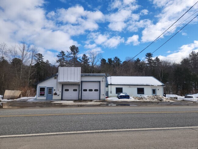
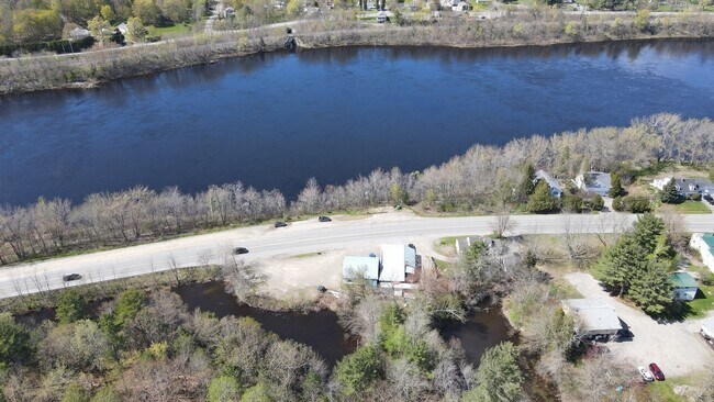
Property Record
857 N Main St, Brewer, ME 04412
Property Detail
857 N Main St
BRER-000017-000000-000060
Penobscot
Autorepair
Maine
CB
60
AE The base floodplain where base flood elevations are provided. AE Zones are now used on new format FIRMs instead of A1-A30 Zones.
0.41 AC
2025
Maine North & Bangor
2025
Other Market Areas
004300
Bangor, ME
3,211 SF
NEARBY LISTINGS FOR SALE OR LEASE
-
-
View all Brewer listings for sale on LoopNet.com
DEMOGRAPHICS near 857 N Main St
1 mile
3 mile
5 mile
2025 Total Population
1,458
26,883
48,658
2030 Population
1,467
27,051
49,472
Pop Growth 2025-2030
+ 0.62%
+ 0.62%
+ 1.67%
Average Age
44
43
43
2025 Total Households
591
12,356
21,896
HH Growth 2025-2030
+ 0.51%
+ 0.51%
+ 1.65%
Median Household Inc
$67,901
$57,969
$64,024
Avg Household Size
2.20
2.00
2.10
2025 Avg HH Vehicles
2.00
1.00
2.00
Median Home Value
$335,714
$260,263
$253,534
Median Year Built
1978
1957
1967
Nearby Places
Map Layers
Map Styles
 Street
 Aerial
Layers
 Traffic
 Biking
Places
Listings with unknown addresses are not visible on the map
- Restaurants
- Banks
- Shops
- Fitness
- Groceries
PUBLIC TRANSPORTATION
AIRPORT
Bangor International
Drive
Walk
Distance
Bangor International
15 min
7.8 mi
Freight Ports
Searsport, ME
Drive
Walk
Distance
Searsport, ME
46 min
32.4 mi
SALE & LEASE HISTORY
LISTING DATE
SALE/LEASE

Mar 10, 2023
For Sale
Nearby Properties
Address
Land Use
TOTAL SIZE
Lot Size
Zoning
Address
Land Use
TOTAL SIZE
Lot Size
Zoning
307,200 SF
99.21 AC
G&ISD
Address
Land Use
TOTAL SIZE
Lot Size
Zoning
Address
Land Use
TOTAL SIZE
Lot Size
Zoning
243,694 SF
2.95 AC
G&ISD
Address
Land Use
TOTAL SIZE
Lot Size
Zoning
11,000 SF
188.98 AC
LDR
Address
Land Use
TOTAL SIZE
Lot Size
Zoning
124,368 SF
11.75 AC
G&ISD
Address
Land Use
TOTAL SIZE
Lot Size
Zoning
241,898 SF
62.50 AC
G&ISD
Address
Land Use
TOTAL SIZE
Lot Size
Zoning
400 SF
3.44 AC
WDD
Address
Land Use
TOTAL SIZE
Lot Size
Zoning
146,924 SF
2.62 AC
G&ISD
Address
Land Use
TOTAL SIZE
Lot Size
Zoning
100,800 SF
1.34 AC
DDD
Address
Land Use
TOTAL SIZE
Lot Size
Zoning
226,625 SF
S&PS
Address
Land Use
TOTAL SIZE
Lot Size
Zoning
94,081 SF
17.56 AC
G&ISD
Address
Land Use
TOTAL SIZE
Lot Size
Zoning
161,540 SF
23.68 AC
GB
Address
Land Use
TOTAL SIZE
Lot Size
Zoning
208,790 SF
50.33 AC
S&PS
Address
Land Use
TOTAL SIZE
Lot Size
Zoning
186,197 SF
21.70 AC
S&PS
Address
Land Use
TOTAL SIZE
Lot Size
Zoning
7 AC
WDD
Address
Land Use
TOTAL SIZE
Lot Size
Zoning
183,507 SF
44.60 AC
G&ISD
Address
Land Use
TOTAL SIZE
Lot Size
Zoning
139,863 SF
20.68 AC
GB
Address
Land Use
TOTAL SIZE
Lot Size
Zoning
83,231 SF
15.88 AC
HDR-2
Address
Land Use
TOTAL SIZE
Lot Size
Zoning
109,507 SF
1.96 AC
G&ISD
Address
Land Use
TOTAL SIZE
Lot Size
Zoning
29.50 AC
Address
Land Use
TOTAL SIZE
Lot Size
Zoning
G&ISD
Address
Land Use
TOTAL SIZE
Lot Size
Zoning
32,570 SF
1.38 AC
G&ISD
Address
Land Use
TOTAL SIZE
Lot Size
Zoning
104,534 SF
5 AC
GC&S
Address
Land Use
TOTAL SIZE
Lot Size
Zoning
604,872 SF
67.61 AC
S&PS
Address
Land Use
TOTAL SIZE
Lot Size
Zoning
44,318 SF
23.67 AC
G&ISD
Address
Land Use
TOTAL SIZE
Lot Size
Zoning
140,059 SF
15.38 AC
S&PS
Address
Land Use
TOTAL SIZE
Lot Size
Zoning
Address
Land Use
TOTAL SIZE
Lot Size
Zoning
130,786 SF
17.33 AC
GC&S
Address
Land Use
TOTAL SIZE
Lot Size
Zoning
123,814 SF
11.23 AC
GC&S
Address
Land Use
TOTAL SIZE
Lot Size
Zoning
107,000 SF
10.40 AC
GC&S
The World's #1 Commercial Real Estate Marketplace
Connect with us
© 2026 CoStar Group
The information above has been obtained from sources believed reliable. While we do not doubt its accuracy we have not verified it and make no guarantee, warranty or representation about it. It is your responsibility to independently confirm its accuracy and completeness. Any projections, opinions, assumptions, or estimates used are for example only and do not represent the current or future performance of the property. The value of this transaction to you depends on tax and other factors which should be evaluated by your tax, financial, and legal advisors. You and your advisors should conduct a careful, independent investigation of the property to determine to your satisfaction the suitability of the property for your needs.