Property Record
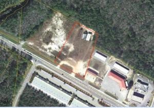
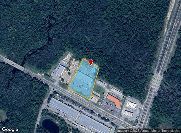
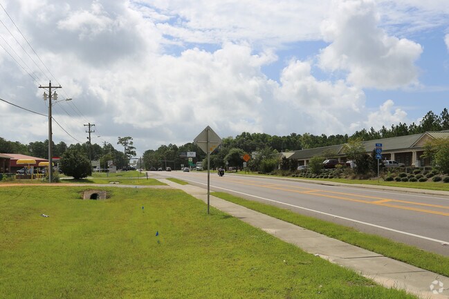
857 State Highway 20 E, Freeport, FL 32439
NEARBY LISTINGS FOR SALE OR LEASE
Property Detail
857 State Highway 20 E
14-1S-19-23000-012-0051
COM NW/C OF NW1/4 OF SW1/4 SEC 14, S 89 DEG 0110E 111.35FT S 62 DEG 0633E 509.29FT TO POB, S 62 DEG 0633E 209.50FT S 17 DEG 2627W 416FT TO NELY ROW OF HWY 20 N 62 DEG 0633W 284.96FT DPRT ROW N 27 DEG 53 27E 409.10FT TO POB. OR 2719-4683 OR 3013-2295
Regionalshoppingcenterormallwithanchorstore
Walton
AE
Florida
12131C0576H
51
2025
2.68 AC
2025
Florida Panhandle Area
950501
Other Market Areas
17,730 SF
Crestview-Fort Walton Beach-Destin, FL
DEMOGRAPHICS near 857 State Highway 20 E
1 Mile
3 Mile
5 Mile
2024 Total Population
926
6,240
10,156
2029 Population
1,141
7,791
12,602
Pop Growth 2024-2029
+ 23.22%
+ 24.86%
+ 24.08%
Average Age
38
38
38
2024 Total Households
328
2,279
3,743
HH Growth 2024-2029
+ 23.48%
+ 25.23%
+ 24.37%
Median Household Inc
$64,062
$50,089
$49,872
Avg Household Size
2.70
2.70
2.60
2024 Avg HH Vehicles
2.00
2.00
2.00
Median Home Value
$289,999
$289,965
$282,682
Median Year Built
2001
2009
2007
Nearby Places
Map Layers
Map Styles
 Street
 Aerial
- Restaurants
- Banks
- Shops
- Fitness
- Groceries
PUBLIC TRANSPORTATION
AIRPORT
Eglin AFB/Destin-Ft Walton Beach
DRIVE
WALK
Distance
Eglin AFB/Destin-Ft Walton Beach
61 min
29.7 mi
Northwest Florida Beaches International
DRIVE
WALK
Distance
Northwest Florida Beaches International
42 min
30.6 mi
Freight Ports
Port of Panama City
DRIVE
WALK
Distance
Port of Panama City
59 min
41.3 mi
SALE & LEASE HISTORY
LISTING DATE
SALE/LEASE

Feb 16, 2017
For Sale
Nearby Properties
Address
Land Use
TOTAL SIZE
Lot Size
Zoning
Address
Land Use
TOTAL SIZE
Lot Size
Zoning
176,047 SF
29.75 AC
Address
Land Use
TOTAL SIZE
Lot Size
Zoning
469,205 SF
21.39 AC
BYLAGR
Address
Land Use
TOTAL SIZE
Lot Size
Zoning
334,804 SF
13.94 AC
MUNI
Address
Land Use
TOTAL SIZE
Lot Size
Zoning
311,974 SF
7.28 AC
Address
Land Use
TOTAL SIZE
Lot Size
Zoning
161,667 SF
26.97 AC
3310
Address
Land Use
TOTAL SIZE
Lot Size
Zoning
83,348 SF
12.68 AC
MUNI
Address
Land Use
TOTAL SIZE
Lot Size
Zoning
63,166 SF
9.06 AC
3310
Address
Land Use
TOTAL SIZE
Lot Size
Zoning
306.09 AC
3310
Address
Land Use
TOTAL SIZE
Lot Size
Zoning
87,549 SF
11 AC
Address
Land Use
TOTAL SIZE
Lot Size
Zoning
Address
Land Use
TOTAL SIZE
Lot Size
Zoning
333.09 AC
3310
Address
Land Use
TOTAL SIZE
Lot Size
Zoning
1,759 SF
0.63 AC
Address
Land Use
TOTAL SIZE
Lot Size
Zoning
88.24 AC
3310
Address
Land Use
TOTAL SIZE
Lot Size
Zoning
81,765 SF
5.51 AC
BYLAGR
Address
Land Use
TOTAL SIZE
Lot Size
Zoning
46,904 SF
93.38 AC
BYLAGR
Address
Land Use
TOTAL SIZE
Lot Size
Zoning
2,072 SF
23.08 AC
MUNI
Address
Land Use
TOTAL SIZE
Lot Size
Zoning
5,624 SF
1.35 AC
3310
Address
Land Use
TOTAL SIZE
Lot Size
Zoning
31,217 SF
5.45 AC
3310
Address
Land Use
TOTAL SIZE
Lot Size
Zoning
12,472 SF
10.63 AC
Address
Land Use
TOTAL SIZE
Lot Size
Zoning
51,885 SF
8.65 AC
3310
Address
Land Use
TOTAL SIZE
Lot Size
Zoning
16,297 SF
13.93 AC
Address
Land Use
TOTAL SIZE
Lot Size
Zoning
4,400 SF
6.04 AC
3310
Address
Land Use
TOTAL SIZE
Lot Size
Zoning
16,804 SF
2.07 AC
Address
Land Use
TOTAL SIZE
Lot Size
Zoning
Address
Land Use
TOTAL SIZE
Lot Size
Zoning
12,290 SF
1.45 AC
Address
Land Use
TOTAL SIZE
Lot Size
Zoning
30,164 SF
2.23 AC
3310
Address
Land Use
TOTAL SIZE
Lot Size
Zoning
10.84 AC
MUNI
Address
Land Use
TOTAL SIZE
Lot Size
Zoning
12,080 SF
3.50 AC
3310
Address
Land Use
TOTAL SIZE
Lot Size
Zoning
924 SF
11.89 AC
3310
The World's #1 Commercial Real Estate Marketplace
Connect with us
© 2025 CoStar Group
The information above has been obtained from sources believed reliable. While we do not doubt its accuracy we have not verified it and make no guarantee, warranty or representation about it. It is your responsibility to independently confirm its accuracy and completeness. Any projections, opinions, assumptions, or estimates used are for example only and do not represent the current or future performance of the property. The value of this transaction to you depends on tax and other factors which should be evaluated by your tax, financial, and legal advisors. You and your advisors should conduct a careful, independent investigation of the property to determine to your satisfaction the suitability of the property for your needs.