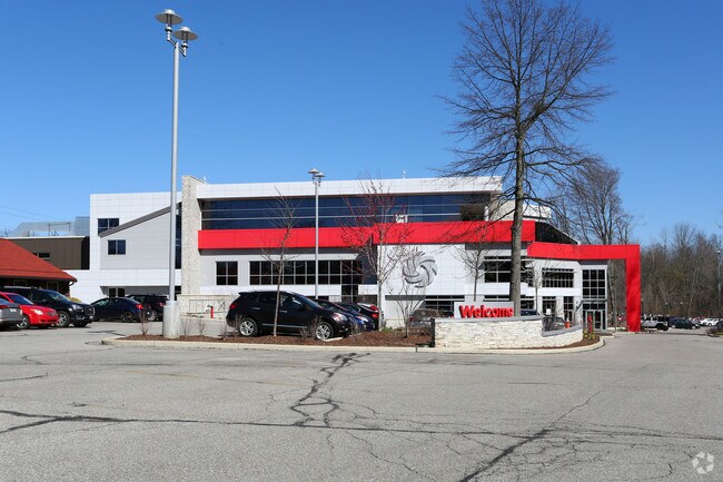
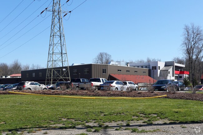
Property Record
8575 Usher Rd, Olmsted Twp, OH 44138
Property Detail
8575 Usher Rd
263-11-003
PCL 3 VOL 352 PG 42 16.587AC TR 3 ADDITIONAL PARCELS 26311004, 005,008,009 010 THRU 013 BALANCE IN 291-12-001 2008S/R
Lightindustrial
CUYAHOGA
R-40
Ohio
AE The base floodplain where base flood elevations are provided. AE Zones are now used on new format FIRMs instead of A1-A30 Zones.
3
2025
16.59 AC
2025
Southwest
176100
Cleveland
188,031 SF
Cleveland-Elyria, OH
NEARBY LISTINGS FOR SALE OR LEASE
DEMOGRAPHICS near 8575 Usher Rd
1 mile
3 mile
5 mile
2025 Total Population
5,396
49,438
116,149
2030 Population
5,347
49,272
115,734
Pop Growth 2025-2030
(0.91%)
(0.34%)
(0.36%)
Average Age
44
43
44
2025 Total Households
2,236
20,692
48,434
HH Growth 2025-2030
(1.07%)
(0.30%)
(0.45%)
Median Household Inc
$90,728
$89,532
$88,151
Avg Household Size
2.40
2.30
2.30
2025 Avg HH Vehicles
2.00
2.00
2.00
Median Home Value
$247,393
$247,673
$246,865
Median Year Built
1973
1975
1972
Nearby Places
Map Layers
Map Styles
 Street
 Aerial
Layers
 Traffic
 Biking
Places
Listings with unknown addresses are not visible on the map
- Restaurants
- Banks
- Shops
- Fitness
- Groceries
PUBLIC TRANSPORTATION
AIRPORT
Cleveland-Hopkins International
Drive
Walk
Distance
Cleveland-Hopkins International
17 min
7.3 mi
Freight Ports
Port of Toledo
Drive
Walk
Distance
Port of Toledo
122 min
99.5 mi
Nearby Properties
Address
Land Use
TOTAL SIZE
Lot Size
Zoning
Address
Land Use
TOTAL SIZE
Lot Size
Zoning
1,514 SF
23.65 AC
RSF-B
Address
Land Use
TOTAL SIZE
Lot Size
Zoning
278,056 SF
42.71 AC
R-40
Address
Land Use
TOTAL SIZE
Lot Size
Zoning
195,990 SF
46.88 AC
RMF-A
Address
Land Use
TOTAL SIZE
Lot Size
Zoning
64,528 SF
17.67 AC
1F-4
Address
Land Use
TOTAL SIZE
Lot Size
Zoning
46,133 SF
35.03 AC
RMF-A
Address
Land Use
TOTAL SIZE
Lot Size
Zoning
209,822 SF
26.92 AC
R-40
Address
Land Use
TOTAL SIZE
Lot Size
Zoning
334,360 SF
8.22 AC
MF-HD
Address
Land Use
TOTAL SIZE
Lot Size
Zoning
2,034 SF
5.49 AC
R-15
Address
Land Use
TOTAL SIZE
Lot Size
Zoning
112,629 SF
9.62 AC
RSF-B
Address
Land Use
TOTAL SIZE
Lot Size
Zoning
59,296 SF
7.08 AC
CC
Address
Land Use
TOTAL SIZE
Lot Size
Zoning
19,614 SF
353.71 AC
1F-4
Address
Land Use
TOTAL SIZE
Lot Size
Zoning
141,245 SF
8.90 AC
1F1
Address
Land Use
TOTAL SIZE
Lot Size
Zoning
179,879 SF
5.34 AC
RMF-A
Address
Land Use
TOTAL SIZE
Lot Size
Zoning
208,960 SF
10.51 AC
MF-MD
Address
Land Use
TOTAL SIZE
Lot Size
Zoning
59,296 SF
7.08 AC
CC
Address
Land Use
TOTAL SIZE
Lot Size
Zoning
67,047 SF
5 AC
1F-4
Address
Land Use
TOTAL SIZE
Lot Size
Zoning
651 SF
0.13 AC
Address
Land Use
TOTAL SIZE
Lot Size
Zoning
54,718 SF
149.12 AC
R-40
Address
Land Use
TOTAL SIZE
Lot Size
Zoning
21,110 SF
2.53 AC
CC
Address
Land Use
TOTAL SIZE
Lot Size
Zoning
192.88 AC
PG
Address
Land Use
TOTAL SIZE
Lot Size
Zoning
90,351 SF
9.46 AC
D-5
Address
Land Use
TOTAL SIZE
Lot Size
Zoning
171.19 AC
RSF-B
Address
Land Use
TOTAL SIZE
Lot Size
Zoning
164.79 AC
RSF-B
Address
Land Use
TOTAL SIZE
Lot Size
Zoning
130,800 SF
38.73 AC
RMF-T
Address
Land Use
TOTAL SIZE
Lot Size
Zoning
91,557 SF
22.50 AC
MUPD
Address
Land Use
TOTAL SIZE
Lot Size
Zoning
64,106 SF
1.29 AC
CC
Address
Land Use
TOTAL SIZE
Lot Size
Zoning
121,778 SF
23.40 AC
D-3
Address
Land Use
TOTAL SIZE
Lot Size
Zoning
61,251 SF
1.89 AC
D-3
Address
Land Use
TOTAL SIZE
Lot Size
Zoning
30,076 SF
5.96 AC
CC
The World's #1 Commercial Real Estate Marketplace
Connect with us
© 2026 CoStar Group
The information above has been obtained from sources believed reliable. While we do not doubt its accuracy we have not verified it and make no guarantee, warranty or representation about it. It is your responsibility to independently confirm its accuracy and completeness. Any projections, opinions, assumptions, or estimates used are for example only and do not represent the current or future performance of the property. The value of this transaction to you depends on tax and other factors which should be evaluated by your tax, financial, and legal advisors. You and your advisors should conduct a careful, independent investigation of the property to determine to your satisfaction the suitability of the property for your needs.