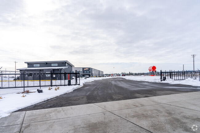
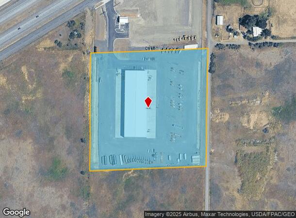
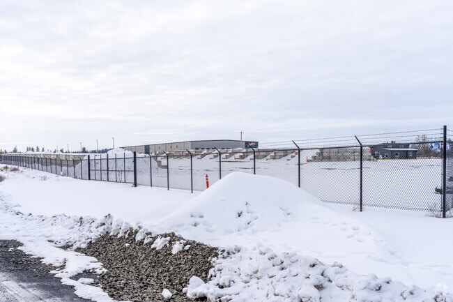
Property Record
8579 W Westbow Blvd, Spokane, WA 99224
Current Lease Availabilities
NEARBY LISTINGS FOR SALE OR LEASE
Property Detail
8579 W Westbow Blvd
Spokane-Spokane Valley, WA
Jamieson Park
24052.0402
JAMIESON PARK LOTS 1-5 & 16-20, BLOCK 6.
Wholesaleoutletdiscountstore
Spokane
X
Washington
53063C0700D
1,20
2025
9.11 AC
2025
West Plains
013600
Spokane
43,200 SF
DEMOGRAPHICS near 8579 W Westbow Blvd
1 Mile
3 Mile
5 Mile
2024 Total Population
975
9,230
32,477
2029 Population
1,064
9,963
35,010
Pop Growth 2024-2029
+ 9.13%
+ 7.94%
+ 7.80%
Average Age
40
38
39
2024 Total Households
368
3,478
12,109
HH Growth 2024-2029
+ 9.24%
+ 8.17%
+ 8.10%
Median Household Inc
$76,923
$77,574
$69,448
Avg Household Size
2.60
2.60
2.50
2024 Avg HH Vehicles
2.00
2.00
2.00
Median Home Value
$333,636
$371,349
$370,737
Median Year Built
2001
2003
2002
Nearby Places
Map Layers
Map Styles
 Street
 Aerial
- Restaurants
- Banks
- Shops
- Fitness
- Groceries
PUBLIC TRANSPORTATION
COMMUTER RAIL
Spokane (Empire Builder - Amtrak)
DRIVE
WALK
Distance
Spokane (Empire Builder - Amtrak)
13 min
7.8 mi
AIRPORT
Spokane International
DRIVE
WALK
Distance
Spokane International
8 min
3.8 mi
Freight Ports
Port of Everett
DRIVE
WALK
Distance
Port of Everett
335 min
296.5 mi
Nearby Properties
Address
Land Use
TOTAL SIZE
Lot Size
Zoning
Address
Land Use
TOTAL SIZE
Lot Size
Zoning
2,689,133 SF
79.07 AC
LI
Address
Land Use
TOTAL SIZE
Lot Size
Zoning
702,957 SF
277.93 AC
Address
Land Use
TOTAL SIZE
Lot Size
Zoning
808,710 SF
646.44 AC
Address
Land Use
TOTAL SIZE
Lot Size
Zoning
546,897 SF
27.69 AC
Address
Land Use
TOTAL SIZE
Lot Size
Zoning
306,250 SF
16.11 AC
LI
Address
Land Use
TOTAL SIZE
Lot Size
Zoning
562,448 SF
62 AC
LI
Address
Land Use
TOTAL SIZE
Lot Size
Zoning
118,996 SF
8.21 AC
LI
Address
Land Use
TOTAL SIZE
Lot Size
Zoning
218,400 SF
14.69 AC
Address
Land Use
TOTAL SIZE
Lot Size
Zoning
197,933 SF
37.51 AC
UR
Address
Land Use
TOTAL SIZE
Lot Size
Zoning
278,722 SF
44.44 AC
RC
Address
Land Use
TOTAL SIZE
Lot Size
Zoning
303,597 SF
62.39 AC
LDR
Address
Land Use
TOTAL SIZE
Lot Size
Zoning
187,000 SF
12.43 AC
I-2
Address
Land Use
TOTAL SIZE
Lot Size
Zoning
314,707 SF
16 AC
LI
Address
Land Use
TOTAL SIZE
Lot Size
Zoning
177,707 SF
44.44 AC
LI
Address
Land Use
TOTAL SIZE
Lot Size
Zoning
122,949 SF
11.07 AC
LI
Address
Land Use
TOTAL SIZE
Lot Size
Zoning
159,706 SF
918.26 AC
LI
Address
Land Use
TOTAL SIZE
Lot Size
Zoning
147,774 SF
6.64 AC
RC
Address
Land Use
TOTAL SIZE
Lot Size
Zoning
59,171 SF
10.12 AC
Address
Land Use
TOTAL SIZE
Lot Size
Zoning
104,889 SF
21.60 AC
LI
Address
Land Use
TOTAL SIZE
Lot Size
Zoning
263,013 SF
10.12 AC
LI
Address
Land Use
TOTAL SIZE
Lot Size
Zoning
141,000 SF
14.82 AC
Address
Land Use
TOTAL SIZE
Lot Size
Zoning
508,598 SF
28.78 AC
LI
Address
Land Use
TOTAL SIZE
Lot Size
Zoning
387,963 SF
49.93 AC
LI
Address
Land Use
TOTAL SIZE
Lot Size
Zoning
108,962 SF
14.58 AC
Address
Land Use
TOTAL SIZE
Lot Size
Zoning
91,482 SF
5.13 AC
MDR
Address
Land Use
TOTAL SIZE
Lot Size
Zoning
101,970 SF
7.88 AC
LI
Address
Land Use
TOTAL SIZE
Lot Size
Zoning
155,344 SF
28.64 AC
LI
Address
Land Use
TOTAL SIZE
Lot Size
Zoning
23,494 SF
8.32 AC
LI
Address
Land Use
TOTAL SIZE
Lot Size
Zoning
82,446 SF
3.55 AC
RC
Address
Land Use
TOTAL SIZE
Lot Size
Zoning
55,719 SF
9.94 AC
LI
The World's #1 Commercial Real Estate Marketplace
Connect with us
© 2025 CoStar Group
The information above has been obtained from sources believed reliable. While we do not doubt its accuracy we have not verified it and make no guarantee, warranty or representation about it. It is your responsibility to independently confirm its accuracy and completeness. Any projections, opinions, assumptions, or estimates used are for example only and do not represent the current or future performance of the property. The value of this transaction to you depends on tax and other factors which should be evaluated by your tax, financial, and legal advisors. You and your advisors should conduct a careful, independent investigation of the property to determine to your satisfaction the suitability of the property for your needs.