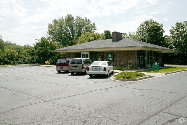
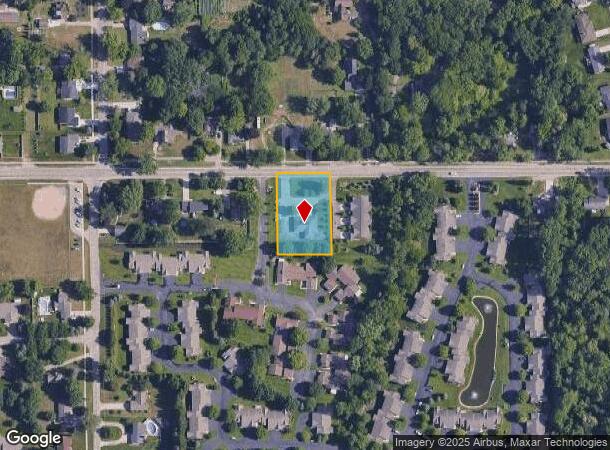
Property Record
858 W 32Nd St, Holland, MI 49423
NEARBY LISTINGS FOR SALE OR LEASE
Property Detail
858 W 32Nd St
11-001-001-10
Willow Creek Condominium
Officebuilding
COM AT N 1/4 PST TH E ON N SEC LIN 521.05' TO POB TH CONT E ON SD N LIN 155' TH S 00 DEG 07'27 E 233' TH N 89 DEG 22'12 W
X
Allegan
26005C0020G
Michigan
2024
0.83 AC
2025
NE Allegan/Holland
032600
West Michigan
1,738 SF
Holland, MI
DEMOGRAPHICS near 858 W 32Nd St
1 Mile
3 Mile
5 Mile
2024 Total Population
5,744
43,529
79,013
2029 Population
5,941
45,335
82,468
Pop Growth 2024-2029
+ 3.43%
+ 4.15%
+ 4.37%
Average Age
43
40
40
2024 Total Households
2,371
16,418
29,886
HH Growth 2024-2029
+ 3.33%
+ 4.28%
+ 4.52%
Median Household Inc
$70,643
$75,781
$73,269
Avg Household Size
2.40
2.40
2.50
2024 Avg HH Vehicles
2.00
2.00
2.00
Median Home Value
$255,886
$251,089
$246,531
Median Year Built
1971
1970
1979
Nearby Places
Map Layers
Map Styles
 Street
 Aerial
- Restaurants
- Banks
- Shops
- Fitness
- Groceries
PUBLIC TRANSPORTATION
COMMUTER RAIL
DRIVE
WALK
Distance
9 min
3.7 mi
AIRPORT
Gerald R Ford International
DRIVE
WALK
Distance
Gerald R Ford International
52 min
39.2 mi
Nearby Properties
Address
Land Use
TOTAL SIZE
Lot Size
Zoning
Address
Land Use
TOTAL SIZE
Lot Size
Zoning
572,832 SF
10.89 AC
PUD
Address
Land Use
TOTAL SIZE
Lot Size
Zoning
198,712 SF
Address
Land Use
TOTAL SIZE
Lot Size
Zoning
556,819 SF
85.45 AC
Address
Land Use
TOTAL SIZE
Lot Size
Zoning
329,784 SF
38.51 AC
I-2
Address
Land Use
TOTAL SIZE
Lot Size
Zoning
154,107 SF
Address
Land Use
TOTAL SIZE
Lot Size
Zoning
589,649 SF
92.65 AC
Address
Land Use
TOTAL SIZE
Lot Size
Zoning
137,732 SF
12.94 AC
C-2
Address
Land Use
TOTAL SIZE
Lot Size
Zoning
94,790 SF
1.74 AC
C-2
Address
Land Use
TOTAL SIZE
Lot Size
Zoning
177,800 SF
12.34 AC
I-2
Address
Land Use
TOTAL SIZE
Lot Size
Zoning
114,088 SF
10.79 AC
PRD
Address
Land Use
TOTAL SIZE
Lot Size
Zoning
181,754 SF
13.44 AC
R3
Address
Land Use
TOTAL SIZE
Lot Size
Zoning
372,017 SF
17.60 AC
R-2
Address
Land Use
TOTAL SIZE
Lot Size
Zoning
73,700 SF
Address
Land Use
TOTAL SIZE
Lot Size
Zoning
158,661 SF
17.28 AC
Address
Land Use
TOTAL SIZE
Lot Size
Zoning
122,026 SF
15.03 AC
R3
Address
Land Use
TOTAL SIZE
Lot Size
Zoning
146,357 SF
20.04 AC
Address
Land Use
TOTAL SIZE
Lot Size
Zoning
22,344 SF
8.16 AC
R-3
Address
Land Use
TOTAL SIZE
Lot Size
Zoning
386,644 SF
22.74 AC
I
Address
Land Use
TOTAL SIZE
Lot Size
Zoning
201,907 SF
15.96 AC
I-2
Address
Land Use
TOTAL SIZE
Lot Size
Zoning
55,088 SF
Address
Land Use
TOTAL SIZE
Lot Size
Zoning
140,700 SF
20.28 AC
Address
Land Use
TOTAL SIZE
Lot Size
Zoning
133,887 SF
13.50 AC
NA
Address
Land Use
TOTAL SIZE
Lot Size
Zoning
33,605 SF
0.25 AC
C-3
Address
Land Use
TOTAL SIZE
Lot Size
Zoning
77,643 SF
3.79 AC
C-2
Address
Land Use
TOTAL SIZE
Lot Size
Zoning
91,294 SF
18.84 AC
NA
Address
Land Use
TOTAL SIZE
Lot Size
Zoning
238,987 SF
38.35 AC
NA
Address
Land Use
TOTAL SIZE
Lot Size
Zoning
42,831 SF
0.67 AC
C-3
Address
Land Use
TOTAL SIZE
Lot Size
Zoning
17,854 SF
3.94 AC
C-2
Address
Land Use
TOTAL SIZE
Lot Size
Zoning
123,370 SF
9.89 AC
I2
Address
Land Use
TOTAL SIZE
Lot Size
Zoning
59,836 SF
6.70 AC
NA
The World's #1 Commercial Real Estate Marketplace
Connect with us
© 2025 CoStar Group
The information above has been obtained from sources believed reliable. While we do not doubt its accuracy we have not verified it and make no guarantee, warranty or representation about it. It is your responsibility to independently confirm its accuracy and completeness. Any projections, opinions, assumptions, or estimates used are for example only and do not represent the current or future performance of the property. The value of this transaction to you depends on tax and other factors which should be evaluated by your tax, financial, and legal advisors. You and your advisors should conduct a careful, independent investigation of the property to determine to your satisfaction the suitability of the property for your needs.