Property Record
85Th St, Sioux Falls, SD 57108
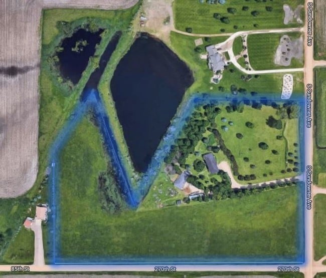
This Property Is For Sale
Property Detail
85Th St
100.50.53.C300
TRACT 1 COOKE'S SUBD SE14 13-100-51
Vacantlandnec
LINCOLN
A-1 AGRICU
South Dakota
B and X Area of moderate flood hazard, usually the area between the limits of the 100-year and 500-year floods.
6.14 AC
2025
Sioux Falls
2025
Other Market Areas
010115
Sioux Falls, SD-MN
NEARBY LISTINGS FOR SALE OR LEASE
DEMOGRAPHICS near 85Th St
1 mile
3 mile
5 mile
2025 Total Population
543
47,674
101,079
2030 Population
616
51,966
109,143
Pop Growth 2025-2030
+ 13.44%
+ 9.00%
+ 7.98%
Average Age
39
37
38
2025 Total Households
177
19,117
40,854
HH Growth 2025-2030
+ 13.56%
+ 9.12%
+ 8.19%
Median Household Inc
$125,641
$81,402
$81,201
Avg Household Size
3.10
2.50
2.40
2025 Avg HH Vehicles
3.00
2.00
2.00
Median Home Value
$450,000
$311,369
$331,379
Median Year Built
2005
2003
2001
Nearby Places
Map Layers
Map Styles
 Street
 Aerial
Layers
 Traffic
 Biking
Places
Listings with unknown addresses are not visible on the map
- Restaurants
- Banks
- Shops
- Fitness
- Groceries
PUBLIC TRANSPORTATION
AIRPORT
Joe Foss Field
Drive
Walk
Distance
Joe Foss Field
33 min
13.5 mi
Freight Ports
Port Milwaukee
Drive
Walk
Distance
Port Milwaukee
560 min
513.0 mi
Nearby Properties
Address
Land Use
TOTAL SIZE
Lot Size
Zoning
Address
Land Use
TOTAL SIZE
Lot Size
Zoning
32.77 AC
Address
Land Use
TOTAL SIZE
Lot Size
Zoning
8.89 AC
MUNICIPALI
Address
Land Use
TOTAL SIZE
Lot Size
Zoning
408,018 SF
53.02 AC
FP;FP
Address
Land Use
TOTAL SIZE
Lot Size
Zoning
8.80 AC
MUNICIPALI
Address
Land Use
TOTAL SIZE
Lot Size
Zoning
8.25 AC
MUNICIPALI
Address
Land Use
TOTAL SIZE
Lot Size
Zoning
11.26 AC
MUNICIPALI
Address
Land Use
TOTAL SIZE
Lot Size
Zoning
8.52 AC
MUNICIPALI
Address
Land Use
TOTAL SIZE
Lot Size
Zoning
15.40 AC
MUNICIPALI
Address
Land Use
TOTAL SIZE
Lot Size
Zoning
10.75 AC
MUNICIPALI
Address
Land Use
TOTAL SIZE
Lot Size
Zoning
9.45 AC
MUNICIPALI
Address
Land Use
TOTAL SIZE
Lot Size
Zoning
80,964 SF
23.34 AC
Address
Land Use
TOTAL SIZE
Lot Size
Zoning
8.60 AC
MUNICIPALI
Address
Land Use
TOTAL SIZE
Lot Size
Zoning
9.56 AC
MUNICIPALI
Address
Land Use
TOTAL SIZE
Lot Size
Zoning
9.59 AC
MUNICIPALI
Address
Land Use
TOTAL SIZE
Lot Size
Zoning
8.57 AC
MUNICIPALI
Address
Land Use
TOTAL SIZE
Lot Size
Zoning
16.45 AC
MUNICIPALI
Address
Land Use
TOTAL SIZE
Lot Size
Zoning
11.12 AC
MUNICIPALI
Address
Land Use
TOTAL SIZE
Lot Size
Zoning
7.07 AC
MUNICIPALI
Address
Land Use
TOTAL SIZE
Lot Size
Zoning
3.43 AC
MUNICIPALI
Address
Land Use
TOTAL SIZE
Lot Size
Zoning
220,834 SF
11.46 AC
Address
Land Use
TOTAL SIZE
Lot Size
Zoning
211,577 SF
11.58 AC
Address
Land Use
TOTAL SIZE
Lot Size
Zoning
7.11 AC
MUNICIPALI
Address
Land Use
TOTAL SIZE
Lot Size
Zoning
11.07 AC
MUNICIPALI
Address
Land Use
TOTAL SIZE
Lot Size
Zoning
11.83 AC
I-1 LIGHT
Address
Land Use
TOTAL SIZE
Lot Size
Zoning
9.27 AC
MUNICIPALI
Address
Land Use
TOTAL SIZE
Lot Size
Zoning
4.38 AC
MUNICIPALI
Address
Land Use
TOTAL SIZE
Lot Size
Zoning
3.97 AC
MUNICIPALI
Address
Land Use
TOTAL SIZE
Lot Size
Zoning
9.16 AC
MUNICIPALI
Address
Land Use
TOTAL SIZE
Lot Size
Zoning
5,649 SF
9.13 AC
Address
Land Use
TOTAL SIZE
Lot Size
Zoning
5.27 AC
MUNICIPALI
The World's #1 Commercial Real Estate Marketplace
Connect with us
© 2026 CoStar Group
The information above has been obtained from sources believed reliable. While we do not doubt its accuracy we have not verified it and make no guarantee, warranty or representation about it. It is your responsibility to independently confirm its accuracy and completeness. Any projections, opinions, assumptions, or estimates used are for example only and do not represent the current or future performance of the property. The value of this transaction to you depends on tax and other factors which should be evaluated by your tax, financial, and legal advisors. You and your advisors should conduct a careful, independent investigation of the property to determine to your satisfaction the suitability of the property for your needs.