Property Record
86 Keystone Ave, Santa Clara, CA 95051
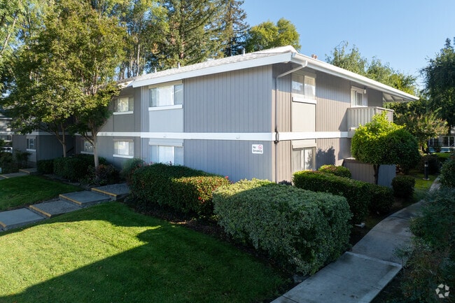

Property Detail
86 Keystone Ave
294-39-001
MAP B7 833
Multifamilydwelling
SANTA CLARA
R3
California
C and X Area of minimal flood hazard, usually depicted on FIRMs as above the 500-year flood level.
2.98 AC
2024
Outer Santa Clara
2025
South Bay/San Jose
506102
San Jose-Sunnyvale-Santa Clara, CA
71,780 SF
NEARBY LISTINGS FOR SALE OR LEASE
DEMOGRAPHICS near 86 Keystone Ave
1 mile
3 mile
5 mile
2025 Total Population
34,577
265,868
594,615
2030 Population
35,464
272,367
610,269
Pop Growth 2025-2030
+ 2.57%
+ 2.44%
+ 2.63%
Average Age
39
39
40
2025 Total Households
13,178
96,671
221,193
HH Growth 2025-2030
+ 2.52%
+ 2.46%
+ 2.73%
Median Household Inc
$141,615
$151,764
$160,328
Avg Household Size
2.60
2.60
2.60
2025 Avg HH Vehicles
2.00
2.00
2.00
Median Home Value
$1,114,541
$1,121,124
$1,122,711
Median Year Built
1970
1968
1970
Nearby Places
Map Layers
Map Styles
 Street
 Aerial
Layers
 Traffic
 Biking
Places
Listings with unknown addresses are not visible on the map
- Restaurants
- Banks
- Shops
- Fitness
- Groceries
PUBLIC TRANSPORTATION
COMMUTER RAIL
University-Santa Clara (ACE Train - Caltrain (Caltrain), Capitol Corridor - Caltrain (Caltrain), Limited - Caltrain (Caltrain), Local Weekday - Caltrain (Caltrain), Local Weekend - Caltrain (Caltrain))
Drive
Walk
Distance
University-Santa Clara (ACE Train - Caltrain (Caltrain), Capitol Corridor - Caltrain (Caltrain), Limited - Caltrain (Caltrain), Local Weekday - Caltrain (Caltrain), Local Weekend - Caltrain (Caltrain))
7 min
3.2 mi
Santa Clara Caltrain Station Northbound (Limited - Caltrain (Caltrain), Local Weekday - Caltrain (Caltrain), Local Weekend - Caltrain (Caltrain))
Drive
Walk
Distance
Santa Clara Caltrain Station Northbound (Limited - Caltrain (Caltrain), Local Weekday - Caltrain (Caltrain), Local Weekend - Caltrain (Caltrain))
7 min
3.2 mi
AIRPORT
Norman Y Mineta San Jose International
Drive
Walk
Distance
Norman Y Mineta San Jose International
9 min
3.9 mi
Freight Ports
Port of Redwood City
Drive
Walk
Distance
Port of Redwood City
29 min
21.9 mi
Nearby Properties
Address
Land Use
TOTAL SIZE
Lot Size
Zoning
Address
Land Use
TOTAL SIZE
Lot Size
Zoning
2,819,800 SF
91.85 AC
CU
Address
Land Use
TOTAL SIZE
Lot Size
Zoning
57,096 SF
58.04 AC
PM0
Address
Land Use
TOTAL SIZE
Lot Size
Zoning
360,000 SF
18.81 AC
MH
Address
Land Use
TOTAL SIZE
Lot Size
Zoning
9.11 AC
ML
Address
Land Use
TOTAL SIZE
Lot Size
Zoning
1,121,228 SF
7.68 AC
RM(PD
Address
Land Use
TOTAL SIZE
Lot Size
Zoning
833,956 SF
55.15 AC
PD
Address
Land Use
TOTAL SIZE
Lot Size
Zoning
304,000 SF
6.79 AC
PM0
Address
Land Use
TOTAL SIZE
Lot Size
Zoning
146,390 SF
9.04 AC
MP
Address
Land Use
TOTAL SIZE
Lot Size
Zoning
4.56 AC
CP
Address
Land Use
TOTAL SIZE
Lot Size
Zoning
32.93 AC
PC
Address
Land Use
TOTAL SIZE
Lot Size
Zoning
1,016,763 SF
7.63 AC
CC
Address
Land Use
TOTAL SIZE
Lot Size
Zoning
457,162 SF
3.97 AC
A(PD)
Address
Land Use
TOTAL SIZE
Lot Size
Zoning
486,104 SF
5.43 AC
ML
Address
Land Use
TOTAL SIZE
Lot Size
Zoning
617,814 SF
21.96 AC
CG
Address
Land Use
TOTAL SIZE
Lot Size
Zoning
174,405 SF
9.24 AC
ML
Address
Land Use
TOTAL SIZE
Lot Size
Zoning
3.40 AC
APD
Address
Land Use
TOTAL SIZE
Lot Size
Zoning
298,461 SF
5.45 AC
C3H
Address
Land Use
TOTAL SIZE
Lot Size
Zoning
4.75 AC
CP-PD
Address
Land Use
TOTAL SIZE
Lot Size
Zoning
346,857 SF
4.26 AC
PD-MC
Address
Land Use
TOTAL SIZE
Lot Size
Zoning
234,622 SF
1.89 AC
A(PD)
Address
Land Use
TOTAL SIZE
Lot Size
Zoning
295,569 SF
30.70 AC
SJ
Address
Land Use
TOTAL SIZE
Lot Size
Zoning
342,432 SF
3.99 AC
PD-MC
Address
Land Use
TOTAL SIZE
Lot Size
Zoning
299,278 SF
3.67 AC
M1
Address
Land Use
TOTAL SIZE
Lot Size
Zoning
16.11 AC
CG
Address
Land Use
TOTAL SIZE
Lot Size
Zoning
279,360 SF
9.04 AC
R3
Address
Land Use
TOTAL SIZE
Lot Size
Zoning
161,375 SF
9.27 AC
PD
Address
Land Use
TOTAL SIZE
Lot Size
Zoning
4.04 AC
CT
Address
Land Use
TOTAL SIZE
Lot Size
Zoning
172,772 SF
3.47 AC
PD
Address
Land Use
TOTAL SIZE
Lot Size
Zoning
814,622 SF
14.57 AC
R3
Address
Land Use
TOTAL SIZE
Lot Size
Zoning
15.11 AC
PC
The World's #1 Commercial Real Estate Marketplace
Connect with us
© 2026 CoStar Group
The information above has been obtained from sources believed reliable. While we do not doubt its accuracy we have not verified it and make no guarantee, warranty or representation about it. It is your responsibility to independently confirm its accuracy and completeness. Any projections, opinions, assumptions, or estimates used are for example only and do not represent the current or future performance of the property. The value of this transaction to you depends on tax and other factors which should be evaluated by your tax, financial, and legal advisors. You and your advisors should conduct a careful, independent investigation of the property to determine to your satisfaction the suitability of the property for your needs.