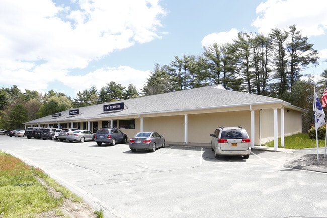
Property Record
86 Main St, Carver, MA 02330

Property Detail
86 Main St
CARV-000071-000000-000007
PLYMOUTH
Commercialofficeresidentialmixeduse
Massachusetts
GB
5.69 AC
B and X Area of moderate flood hazard, usually the area between the limits of the 100-year and 500-year floods.
Route 3 South
0
Boston
2025
Boston-Cambridge-Newton, MA-NH
544100
NEARBY LISTINGS FOR SALE OR LEASE
-
-
View all Carver listings for lease on LoopNet.com
DEMOGRAPHICS near 86 Main St
1 mile
3 mile
5 mile
2024 Total Population
1,433
9,552
27,575
2029 Population
1,444
9,682
28,056
Pop Growth 2024-2029
+ 0.77%
+ 1.36%
+ 1.74%
Average Age
44
44
44
2024 Total Households
563
3,614
10,321
HH Growth 2024-2029
+ 0.89%
+ 1.30%
+ 1.71%
Median Household Inc
$68,043
$86,009
$102,552
Avg Household Size
2.50
2.60
2.60
2024 Avg HH Vehicles
2.00
2.00
2.00
Median Home Value
$423,913
$459,644
$493,020
Median Year Built
1976
1977
1979
Nearby Places
Map Layers
Map Styles
 Street
 Aerial
Transit
 Traffic
 Biking
Places
Listings with unknown addresses are not visible on the map
- Restaurants
- Banks
- Shops
- Fitness
- Groceries
PUBLIC TRANSPORTATION
COMMUTER RAIL
Kingston/Route 3 (Kingston/Plymouth Line - Massachusetts Bay Transportation Authority Commuter Rail (Purple Line))
Drive
Walk
Distance
Kingston/Route 3 (Kingston/Plymouth Line - Massachusetts Bay Transportation Authority Commuter Rail (Purple Line))
20 min
9.0 mi
Freight Ports
Port of New Bedford Harbor
Drive
Walk
Distance
Port of New Bedford Harbor
38 min
26.3 mi
SALE & LEASE HISTORY
LISTING DATE
SALE/LEASE

Sep 25, 2016
For Lease
Sep 23, 2016
For Sale
Mar 27, 2017
For Lease
Jul 17, 2017
For Lease
Aug 03, 2017
For Lease
Nearby Properties
Address
Land Use
TOTAL SIZE
Lot Size
Zoning
Address
Land Use
TOTAL SIZE
Lot Size
Zoning
29.91 AC
RA
Address
Land Use
TOTAL SIZE
Lot Size
Zoning
123,423 SF
22.20 AC
GB
Address
Land Use
TOTAL SIZE
Lot Size
Zoning
15.13 AC
HC
Address
Land Use
TOTAL SIZE
Lot Size
Zoning
33.98 AC
RA
Address
Land Use
TOTAL SIZE
Lot Size
Zoning
290.45 AC
AP
Address
Land Use
TOTAL SIZE
Lot Size
Zoning
16.32 AC
V
Address
Land Use
TOTAL SIZE
Lot Size
Zoning
6.26 AC
V
Address
Land Use
TOTAL SIZE
Lot Size
Zoning
23,126 SF
14.94 AC
V
Address
Land Use
TOTAL SIZE
Lot Size
Zoning
497.03 AC
TC
Address
Land Use
TOTAL SIZE
Lot Size
Zoning
69 AC
TC
Address
Land Use
TOTAL SIZE
Lot Size
Zoning
6 AC
V
Address
Land Use
TOTAL SIZE
Lot Size
Zoning
2.30 AC
AP
Address
Land Use
TOTAL SIZE
Lot Size
Zoning
56,700 SF
Address
Land Use
TOTAL SIZE
Lot Size
Zoning
24,000 SF
3.06 AC
AP
Address
Land Use
TOTAL SIZE
Lot Size
Zoning
1,620 SF
31.28 AC
TC
Address
Land Use
TOTAL SIZE
Lot Size
Zoning
18,885 SF
10.94 AC
AP
Address
Land Use
TOTAL SIZE
Lot Size
Zoning
12.57 AC
RA
Address
Land Use
TOTAL SIZE
Lot Size
Zoning
3.47 AC
GB
Address
Land Use
TOTAL SIZE
Lot Size
Zoning
15,819 SF
1.89 AC
AP
Address
Land Use
TOTAL SIZE
Lot Size
Zoning
1,586 SF
4.06 AC
GB
Address
Land Use
TOTAL SIZE
Lot Size
Zoning
13,070 SF
AP
Address
Land Use
TOTAL SIZE
Lot Size
Zoning
2,376 SF
71.11 AC
AP
Address
Land Use
TOTAL SIZE
Lot Size
Zoning
41,566 SF
5.08 AC
GB
Address
Land Use
TOTAL SIZE
Lot Size
Zoning
42,776 SF
AP
Address
Land Use
TOTAL SIZE
Lot Size
Zoning
26,729 SF
2.84 AC
VB
Address
Land Use
TOTAL SIZE
Lot Size
Zoning
3,090 SF
2.12 AC
AP
Address
Land Use
TOTAL SIZE
Lot Size
Zoning
11,900 SF
1.31 AC
AP
Address
Land Use
TOTAL SIZE
Lot Size
Zoning
2.76 AC
GB
Address
Land Use
TOTAL SIZE
Lot Size
Zoning
654 SF
539.88 AC
RA
Address
Land Use
TOTAL SIZE
Lot Size
Zoning
45.78 AC
AP
The World's #1 Commercial Real Estate Marketplace
Connect with us
© 2026 CoStar Group
The information above has been obtained from sources believed reliable. While we do not doubt its accuracy we have not verified it and make no guarantee, warranty or representation about it. It is your responsibility to independently confirm its accuracy and completeness. Any projections, opinions, assumptions, or estimates used are for example only and do not represent the current or future performance of the property. The value of this transaction to you depends on tax and other factors which should be evaluated by your tax, financial, and legal advisors. You and your advisors should conduct a careful, independent investigation of the property to determine to your satisfaction the suitability of the property for your needs.