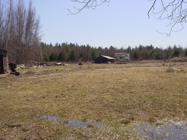
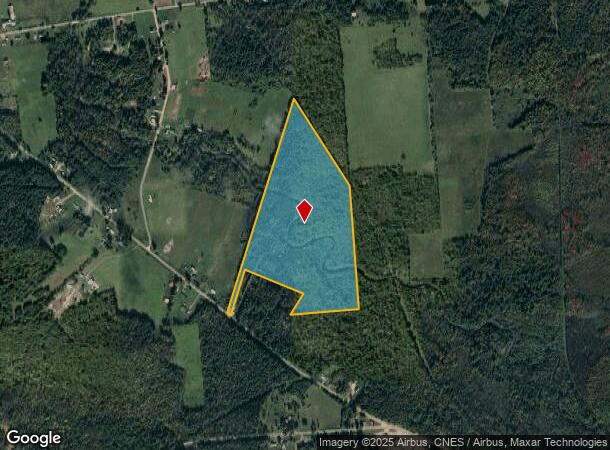
Property Record
86 Wangum Rd, Moira, NY 12957
NEARBY LISTINGS FOR SALE OR LEASE
-
-
View all Moira listings for sale on LoopNet.com
Property Detail
86 Wangum Rd
Other Market Areas
Franklin
165089-106-000-0005-018-100-0000
New York
Residentialacreage
18.100
2025
42.60 AC
2024
Upstate New York Area
950301
DEMOGRAPHICS near 86 Wangum Rd
1 Mile
3 Mile
5 Mile
2024 Total Population
219
1,469
3,317
2029 Population
211
1,417
3,222
Pop Growth 2024-2029
(3.65%)
(3.54%)
(2.86%)
Average Age
40
40
40
2024 Total Households
90
613
1,360
HH Growth 2024-2029
(3.33%)
(3.75%)
(3.16%)
Median Household Inc
$39,772
$46,166
$51,259
Avg Household Size
2.40
2.40
2.40
2024 Avg HH Vehicles
2.00
2.00
2.00
Median Home Value
$136,207
$141,978
$133,289
Median Year Built
1962
1961
1967
Nearby Places
Map Layers
Map Styles
 Street
 Aerial
- Restaurants
- Banks
- Shops
- Fitness
- Groceries
Nearby Properties
Address
Land Use
TOTAL SIZE
Lot Size
Zoning
Address
Land Use
TOTAL SIZE
Lot Size
Zoning
58,060 SF
89.18 AC
Address
Land Use
TOTAL SIZE
Lot Size
Zoning
390.06 AC
02 - SINGL
Address
Land Use
TOTAL SIZE
Lot Size
Zoning
Address
Land Use
TOTAL SIZE
Lot Size
Zoning
1,680 SF
53.32 AC
Address
Land Use
TOTAL SIZE
Lot Size
Zoning
8,100 SF
3.15 AC
Address
Land Use
TOTAL SIZE
Lot Size
Zoning
9,100 SF
1.66 AC
Address
Land Use
TOTAL SIZE
Lot Size
Zoning
Address
Land Use
TOTAL SIZE
Lot Size
Zoning
5,576 SF
3 AC
Address
Land Use
TOTAL SIZE
Lot Size
Zoning
3,136 SF
1.25 AC
Address
Land Use
TOTAL SIZE
Lot Size
Zoning
3,584 SF
1.15 AC
Address
Land Use
TOTAL SIZE
Lot Size
Zoning
573.04 AC
Address
Land Use
TOTAL SIZE
Lot Size
Zoning
2,884 SF
10 AC
Address
Land Use
TOTAL SIZE
Lot Size
Zoning
3,924 SF
3.10 AC
Address
Land Use
TOTAL SIZE
Lot Size
Zoning
Address
Land Use
TOTAL SIZE
Lot Size
Zoning
6,448 SF
0.85 AC
Address
Land Use
TOTAL SIZE
Lot Size
Zoning
2,362 SF
1.60 AC
Address
Land Use
TOTAL SIZE
Lot Size
Zoning
525.30 AC
Address
Land Use
TOTAL SIZE
Lot Size
Zoning
3,120 SF
2.11 AC
Address
Land Use
TOTAL SIZE
Lot Size
Zoning
1,568 SF
45.70 AC
Address
Land Use
TOTAL SIZE
Lot Size
Zoning
1,802 SF
24 AC
N00
Address
Land Use
TOTAL SIZE
Lot Size
Zoning
7,055 SF
5 AC
Address
Land Use
TOTAL SIZE
Lot Size
Zoning
0.01 AC
Address
Land Use
TOTAL SIZE
Lot Size
Zoning
1,956 SF
0.40 AC
Address
Land Use
TOTAL SIZE
Lot Size
Zoning
5,488 SF
0.51 AC
Address
Land Use
TOTAL SIZE
Lot Size
Zoning
3,500 SF
10 AC
Address
Land Use
TOTAL SIZE
Lot Size
Zoning
5,076 SF
1.82 AC
Address
Land Use
TOTAL SIZE
Lot Size
Zoning
1,340 SF
2 AC
Address
Land Use
TOTAL SIZE
Lot Size
Zoning
4,548 SF
0.36 AC
Address
Land Use
TOTAL SIZE
Lot Size
Zoning
4,412 SF
0.50 AC
Address
Land Use
TOTAL SIZE
Lot Size
Zoning
2,128 SF
0.50 AC
The World's #1 Commercial Real Estate Marketplace
Connect with us
© 2026 CoStar Group
The information above has been obtained from sources believed reliable. While we do not doubt its accuracy we have not verified it and make no guarantee, warranty or representation about it. It is your responsibility to independently confirm its accuracy and completeness. Any projections, opinions, assumptions, or estimates used are for example only and do not represent the current or future performance of the property. The value of this transaction to you depends on tax and other factors which should be evaluated by your tax, financial, and legal advisors. You and your advisors should conduct a careful, independent investigation of the property to determine to your satisfaction the suitability of the property for your needs.