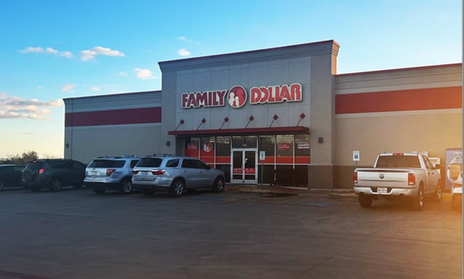
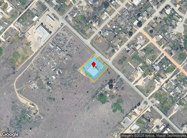
Property Record
860 High Rd, Kyle, TX 78640

Property Detail
860 High Rd
Austin-Round Rock-San Marcos, TX
Kyle G2k Family Dollar
R164510
KYLE G2K FAMILY DOLLAR, BLOCK 1, LOT 1, ACRES 1.08
Commercialnec
Hays
X
Texas
48055C0100E
1
2024
1.08 AC
2025
Hays County
010916
Austin
8,000 SF
NEARBY LISTINGS FOR SALE OR LEASE
DEMOGRAPHICS near 860 High Rd
1 mile
3 mile
5 mile
2024 Total Population
4,427
34,641
88,798
2029 Population
5,737
45,379
115,365
Pop Growth 2024-2029
+ 29.59%
+ 31.00%
+ 29.92%
Average Age
32
34
34
2024 Total Households
1,109
10,590
28,825
HH Growth 2024-2029
+ 30.84%
+ 32.06%
+ 31.03%
Median Household Inc
$36,973
$82,925
$86,466
Avg Household Size
3.70
3.20
3.00
2024 Avg HH Vehicles
2.00
2.00
2.00
Median Home Value
$81,448
$216,486
$246,974
Median Year Built
2003
2009
2010
Nearby Places
Map Layers
Map Styles
 Street
 Aerial
Transit
 Traffic
 Biking
Places
Listings with unknown addresses are not visible on the map
- Restaurants
- Banks
- Shops
- Fitness
- Groceries
PUBLIC TRANSPORTATION
AIRPORT
Austin-Bergstrom International
Drive
Walk
Distance
Austin-Bergstrom International
38 min
23.6 mi
SALE & LEASE HISTORY
LISTING DATE
SALE/LEASE

Jan 29, 2025
For Sale
Nearby Properties
Address
Land Use
TOTAL SIZE
Lot Size
Zoning
Address
Land Use
TOTAL SIZE
Lot Size
Zoning
331,761 SF
57.23 AC
Address
Land Use
TOTAL SIZE
Lot Size
Zoning
403,635 SF
24.01 AC
Address
Land Use
TOTAL SIZE
Lot Size
Zoning
240,002 SF
53.46 AC
Address
Land Use
TOTAL SIZE
Lot Size
Zoning
240,168 SF
9.45 AC
Address
Land Use
TOTAL SIZE
Lot Size
Zoning
212,026 SF
13.82 AC
Address
Land Use
TOTAL SIZE
Lot Size
Zoning
175,604 SF
11.72 AC
Address
Land Use
TOTAL SIZE
Lot Size
Zoning
50,507 SF
3.19 AC
Address
Land Use
TOTAL SIZE
Lot Size
Zoning
924 SF
166.72 AC
Address
Land Use
TOTAL SIZE
Lot Size
Zoning
2,663 SF
176.58 AC
Address
Land Use
TOTAL SIZE
Lot Size
Zoning
117,084 SF
5.45 AC
Address
Land Use
TOTAL SIZE
Lot Size
Zoning
43,209 SF
25.44 AC
Address
Land Use
TOTAL SIZE
Lot Size
Zoning
82,000 SF
21.64 AC
Address
Land Use
TOTAL SIZE
Lot Size
Zoning
59.27 AC
Address
Land Use
TOTAL SIZE
Lot Size
Zoning
2,748 SF
72.33 AC
Address
Land Use
TOTAL SIZE
Lot Size
Zoning
16.15 AC
Address
Land Use
TOTAL SIZE
Lot Size
Zoning
22.03 AC
Address
Land Use
TOTAL SIZE
Lot Size
Zoning
26,180 SF
2.86 AC
Address
Land Use
TOTAL SIZE
Lot Size
Zoning
1,204 SF
4.86 AC
Address
Land Use
TOTAL SIZE
Lot Size
Zoning
90,950 SF
6.14 AC
Address
Land Use
TOTAL SIZE
Lot Size
Zoning
3,510 SF
136.76 AC
Address
Land Use
TOTAL SIZE
Lot Size
Zoning
36.30 AC
Address
Land Use
TOTAL SIZE
Lot Size
Zoning
47.48 AC
Address
Land Use
TOTAL SIZE
Lot Size
Zoning
15,402 SF
2.67 AC
Address
Land Use
TOTAL SIZE
Lot Size
Zoning
12,212 SF
1.37 AC
Address
Land Use
TOTAL SIZE
Lot Size
Zoning
54,796 SF
2.23 AC
Address
Land Use
TOTAL SIZE
Lot Size
Zoning
20,726 SF
4.18 AC
Address
Land Use
TOTAL SIZE
Lot Size
Zoning
21,576 SF
2 AC
Address
Land Use
TOTAL SIZE
Lot Size
Zoning
39,390 SF
14.28 AC
Address
Land Use
TOTAL SIZE
Lot Size
Zoning
28.24 AC
Address
Land Use
TOTAL SIZE
Lot Size
Zoning
6.22 AC
The World's #1 Commercial Real Estate Marketplace
Connect with us
© 2026 CoStar Group
The information above has been obtained from sources believed reliable. While we do not doubt its accuracy we have not verified it and make no guarantee, warranty or representation about it. It is your responsibility to independently confirm its accuracy and completeness. Any projections, opinions, assumptions, or estimates used are for example only and do not represent the current or future performance of the property. The value of this transaction to you depends on tax and other factors which should be evaluated by your tax, financial, and legal advisors. You and your advisors should conduct a careful, independent investigation of the property to determine to your satisfaction the suitability of the property for your needs.