Property Record
8600 Granby St, Norfolk, VA 23503
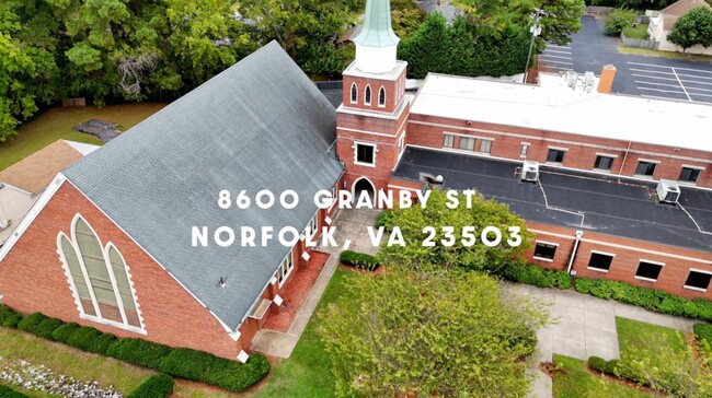


This Property Is For Sale
NEARBY LISTINGS FOR SALE OR LEASE
-
-
View all Norfolk listings for sale on LoopNet.com
Property Detail
8600 Granby St
Virginia Beach-Norfolk-Newport News, VA-NC
Cedars
82258505
LOT G, BLK 1, BAYVIEW PK
Religious
Norfolk City
X
Virginia
5101040017H
g
2025
1.34 AC
2025
Central Norfolk
000700
Hampton Roads
16,424 SF
DEMOGRAPHICS near 8600 Granby St
1 Mile
3 Mile
5 Mile
2024 Total Population
11,453
90,235
176,081
2029 Population
11,148
88,467
173,473
Pop Growth 2024-2029
(2.66%)
(1.96%)
(1.48%)
Average Age
36
37
37
2024 Total Households
4,428
35,495
67,265
HH Growth 2024-2029
(2.80%)
(2.13%)
(1.64%)
Median Household Inc
$66,497
$61,791
$64,865
Avg Household Size
2.40
2.30
2.30
2024 Avg HH Vehicles
2.00
2.00
2.00
Median Home Value
$277,982
$302,201
$305,379
Median Year Built
1954
1963
1963
Nearby Places
Map Layers
Map Styles
 Street
 Aerial
- Restaurants
- Banks
- Shops
- Fitness
- Groceries
PUBLIC TRANSPORTATION
COMMUTER RAIL
Norfolk (Northeast Regional - Amtrak)
DRIVE
WALK
Distance
Norfolk (Northeast Regional - Amtrak)
13 min
7.2 mi
AIRPORT
Norfolk International
DRIVE
WALK
Distance
Norfolk International
12 min
6.3 mi
Newport News/Williamsburg International
DRIVE
WALK
Distance
Newport News/Williamsburg International
33 min
22.9 mi
Freight Ports
Virginia Port Authority - Norfolk
DRIVE
WALK
Distance
Virginia Port Authority - Norfolk
13 min
5.1 mi
Nearby Properties
Address
Land Use
TOTAL SIZE
Lot Size
Zoning
Address
Land Use
TOTAL SIZE
Lot Size
Zoning
1,190.45 AC
Address
Land Use
TOTAL SIZE
Lot Size
Zoning
777.89 AC
Address
Land Use
TOTAL SIZE
Lot Size
Zoning
8,423 SF
53.95 AC
Address
Land Use
TOTAL SIZE
Lot Size
Zoning
40.37 AC
R6
Address
Land Use
TOTAL SIZE
Lot Size
Zoning
213 AC
I5
Address
Land Use
TOTAL SIZE
Lot Size
Zoning
321,691 SF
30.58 AC
Address
Land Use
TOTAL SIZE
Lot Size
Zoning
167,279 SF
9.97 AC
IN1
Address
Land Use
TOTAL SIZE
Lot Size
Zoning
103,496 SF
25.81 AC
IN1
Address
Land Use
TOTAL SIZE
Lot Size
Zoning
11.09 AC
R14
Address
Land Use
TOTAL SIZE
Lot Size
Zoning
6,170 SF
18.46 AC
R13
Address
Land Use
TOTAL SIZE
Lot Size
Zoning
19.47 AC
86
Address
Land Use
TOTAL SIZE
Lot Size
Zoning
52,612 SF
4.94 AC
Address
Land Use
TOTAL SIZE
Lot Size
Zoning
27,840 SF
5.80 AC
R11
Address
Land Use
TOTAL SIZE
Lot Size
Zoning
14.02 AC
Address
Land Use
TOTAL SIZE
Lot Size
Zoning
41,754 SF
6.01 AC
Address
Land Use
TOTAL SIZE
Lot Size
Zoning
170,152 SF
6.07 AC
PDMU1
Address
Land Use
TOTAL SIZE
Lot Size
Zoning
25,880 SF
31.21 AC
91
Address
Land Use
TOTAL SIZE
Lot Size
Zoning
207,440 SF
3.74 AC
R12
Address
Land Use
TOTAL SIZE
Lot Size
Zoning
23.85 AC
IN1
Address
Land Use
TOTAL SIZE
Lot Size
Zoning
21.89 AC
IN1
Address
Land Use
TOTAL SIZE
Lot Size
Zoning
15,898 SF
9.91 AC
IN1
Address
Land Use
TOTAL SIZE
Lot Size
Zoning
21.65 AC
Address
Land Use
TOTAL SIZE
Lot Size
Zoning
177,766 SF
21.65 AC
C3
Address
Land Use
TOTAL SIZE
Lot Size
Zoning
18.39 AC
R11
Address
Land Use
TOTAL SIZE
Lot Size
Zoning
3,944 SF
10.73 AC
R7
Address
Land Use
TOTAL SIZE
Lot Size
Zoning
213,832 SF
20.36 AC
C3
Address
Land Use
TOTAL SIZE
Lot Size
Zoning
47,168 SF
4.87 AC
R14
Address
Land Use
TOTAL SIZE
Lot Size
Zoning
58,424 SF
10.85 AC
Address
Land Use
TOTAL SIZE
Lot Size
Zoning
41,140 SF
7.80 AC
BC1
Address
Land Use
TOTAL SIZE
Lot Size
Zoning
3.22 AC
PDR6
The World's #1 Commercial Real Estate Marketplace
Connect with us
© 2025 CoStar Group
The information above has been obtained from sources believed reliable. While we do not doubt its accuracy we have not verified it and make no guarantee, warranty or representation about it. It is your responsibility to independently confirm its accuracy and completeness. Any projections, opinions, assumptions, or estimates used are for example only and do not represent the current or future performance of the property. The value of this transaction to you depends on tax and other factors which should be evaluated by your tax, financial, and legal advisors. You and your advisors should conduct a careful, independent investigation of the property to determine to your satisfaction the suitability of the property for your needs.