Property Record
8601 Hacks Cross Rd, Olive Branch, MS 38654
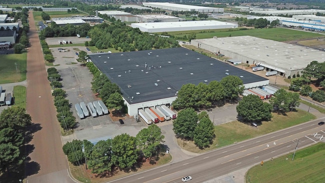
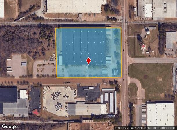
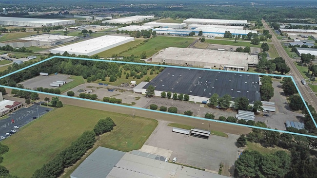
This Property Is For Sale
Current Lease Availabilities
NEARBY LISTINGS FOR SALE OR LEASE
Property Detail
8601 Hacks Cross Rd
1066230000000501
PT E1/2 E1/2 SO OF RR
Commercialnec
DeSoto
X
Mississippi
28033C0110H
5
2025
10.14 AC
2025
DeSoto
070812
Memphis
202,440 SF
Memphis, TN-MS-AR
DEMOGRAPHICS near 8601 Hacks Cross Rd
1 Mile
3 Mile
5 Mile
2024 Total Population
687
41,557
102,564
2029 Population
716
42,658
104,512
Pop Growth 2024-2029
+ 4.22%
+ 2.65%
+ 1.90%
Average Age
36
38
37
2024 Total Households
265
15,314
37,868
HH Growth 2024-2029
+ 4.53%
+ 2.68%
+ 1.81%
Median Household Inc
$54,697
$75,850
$75,308
Avg Household Size
2.60
2.70
2.70
2024 Avg HH Vehicles
2.00
2.00
2.00
Median Home Value
$220,968
$201,154
$208,106
Median Year Built
1997
1997
1994
Nearby Places
Map Layers
Map Styles
 Street
 Aerial
- Restaurants
- Banks
- Shops
- Fitness
- Groceries
PUBLIC TRANSPORTATION
AIRPORT
Memphis International
DRIVE
WALK
Distance
Memphis International
25 min
16.6 mi
Freight Ports
Port of Shreveport
DRIVE
WALK
Distance
Port of Shreveport
429 min
390.4 mi
Nearby Properties
Address
Land Use
TOTAL SIZE
Lot Size
Zoning
Address
Land Use
TOTAL SIZE
Lot Size
Zoning
1,059,729 SF
74.33 AC
M-2
Address
Land Use
TOTAL SIZE
Lot Size
Zoning
929,880 SF
41.14 AC
M-1
Address
Land Use
TOTAL SIZE
Lot Size
Zoning
52,688 SF
24.38 AC
CA
Address
Land Use
TOTAL SIZE
Lot Size
Zoning
10,128 SF
23.35 AC
CA
Address
Land Use
TOTAL SIZE
Lot Size
Zoning
1,150,296 SF
68.41 AC
M-1
Address
Land Use
TOTAL SIZE
Lot Size
Zoning
1,093,788 SF
60.98 AC
M-1
Address
Land Use
TOTAL SIZE
Lot Size
Zoning
990,952 SF
60.30 AC
PUD
Address
Land Use
TOTAL SIZE
Lot Size
Zoning
1,299,800 SF
50.22 AC
M-1
Address
Land Use
TOTAL SIZE
Lot Size
Zoning
990,080 SF
55.79 AC
M-1
Address
Land Use
TOTAL SIZE
Lot Size
Zoning
622,675 SF
67.55 AC
M-1
Address
Land Use
TOTAL SIZE
Lot Size
Zoning
761,349 SF
57.62 AC
M-1
Address
Land Use
TOTAL SIZE
Lot Size
Zoning
722,560 SF
66.85 AC
M-1
Address
Land Use
TOTAL SIZE
Lot Size
Zoning
65,282 SF
15.92 AC
CA
Address
Land Use
TOTAL SIZE
Lot Size
Zoning
615,853 SF
39.07 AC
M-1
Address
Land Use
TOTAL SIZE
Lot Size
Zoning
869,020 SF
43.85 AC
M-1
Address
Land Use
TOTAL SIZE
Lot Size
Zoning
813,440 SF
38.72 AC
PB
Address
Land Use
TOTAL SIZE
Lot Size
Zoning
616,191 SF
61.92 AC
PUD
Address
Land Use
TOTAL SIZE
Lot Size
Zoning
860,040 SF
43.13 AC
M-1
Address
Land Use
TOTAL SIZE
Lot Size
Zoning
927,742 SF
42.73 AC
PB
Address
Land Use
TOTAL SIZE
Lot Size
Zoning
416,000 SF
40.66 AC
M-1
Address
Land Use
TOTAL SIZE
Lot Size
Zoning
447,008 SF
28.41 AC
PB
Address
Land Use
TOTAL SIZE
Lot Size
Zoning
689,628 SF
43.78 AC
M-1
Address
Land Use
TOTAL SIZE
Lot Size
Zoning
599,752 SF
40.17 AC
M-1
Address
Land Use
TOTAL SIZE
Lot Size
Zoning
1,082,465 SF
57.74 AC
PB
Address
Land Use
TOTAL SIZE
Lot Size
Zoning
596,400 SF
43.20 AC
M-2
Address
Land Use
TOTAL SIZE
Lot Size
Zoning
399,672 SF
19.97 AC
M-1
Address
Land Use
TOTAL SIZE
Lot Size
Zoning
430,503 SF
21.24 AC
M-1
Address
Land Use
TOTAL SIZE
Lot Size
Zoning
340,000 SF
28.56 AC
M-2
Address
Land Use
TOTAL SIZE
Lot Size
Zoning
27,669 SF
34.27 AC
R-4
Address
Land Use
TOTAL SIZE
Lot Size
Zoning
480,000 SF
23.80 AC
M-2
The World's #1 Commercial Real Estate Marketplace
Connect with us
© 2025 CoStar Group
The information above has been obtained from sources believed reliable. While we do not doubt its accuracy we have not verified it and make no guarantee, warranty or representation about it. It is your responsibility to independently confirm its accuracy and completeness. Any projections, opinions, assumptions, or estimates used are for example only and do not represent the current or future performance of the property. The value of this transaction to you depends on tax and other factors which should be evaluated by your tax, financial, and legal advisors. You and your advisors should conduct a careful, independent investigation of the property to determine to your satisfaction the suitability of the property for your needs.