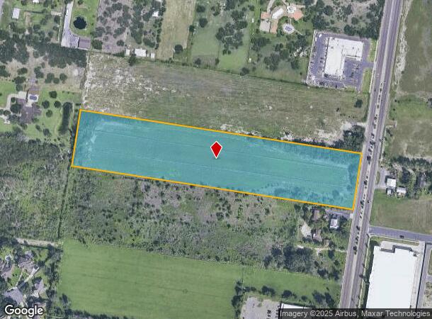
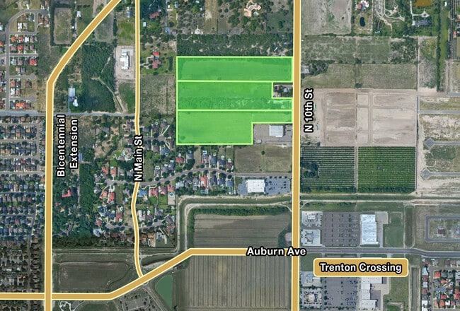
Property Record
8601 N 10Th St, Mcallen, TX 78504
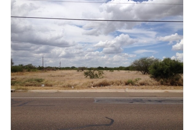
This Property Is For Sale
NEARBY LISTINGS FOR SALE OR LEASE
Property Detail
8601 N 10Th St
McAllen/Edinburg/Pharr
Hidalgo Canal Co-Mc - Sml
McAllen-Edinburg-Mission, TX
HIDALGO CANAL CO-MC -S277.50-N575.42- LOT 3 BLK 13 9.01AC NET
H2550-00-013-0003-07
Hidalgo
Privatepreserveopenspacevacantlandforestlandconservation
Texas
2024
3
2025
9.01 AC
023536
Greater McAllen
DEMOGRAPHICS near 8601 N 10Th St
1 Mile
3 Mile
5 Mile
2024 Total Population
7,004
87,251
218,452
2029 Population
7,428
91,766
230,067
Pop Growth 2024-2029
+ 6.05%
+ 5.17%
+ 5.32%
Average Age
36
35
34
2024 Total Households
2,256
29,577
72,037
HH Growth 2024-2029
+ 6.16%
+ 5.07%
+ 5.23%
Median Household Inc
$58,146
$67,295
$55,028
Avg Household Size
3.10
2.90
3.00
2024 Avg HH Vehicles
2.00
2.00
2.00
Median Home Value
$219,007
$183,525
$163,734
Median Year Built
2003
1999
1999
Nearby Places
Map Layers
Map Styles
 Street
 Aerial
- Restaurants
- Banks
- Shops
- Fitness
- Groceries
PUBLIC TRANSPORTATION
AIRPORT
McAllen International
DRIVE
WALK
Distance
McAllen International
13 min
7.7 mi
Freight Ports
Port of Brownsville
DRIVE
WALK
Distance
Port of Brownsville
75 min
63.7 mi
Nearby Properties
Address
Land Use
TOTAL SIZE
Lot Size
Zoning
Address
Land Use
TOTAL SIZE
Lot Size
Zoning
543,452 SF
53.23 AC
CO
Address
Land Use
TOTAL SIZE
Lot Size
Zoning
407,190 SF
11.04 AC
CO
Address
Land Use
TOTAL SIZE
Lot Size
Zoning
357,818 SF
11.10 AC
Address
Land Use
TOTAL SIZE
Lot Size
Zoning
251,423 SF
27.39 AC
CO
Address
Land Use
TOTAL SIZE
Lot Size
Zoning
128,076 SF
5.01 AC
Address
Land Use
TOTAL SIZE
Lot Size
Zoning
109,791 SF
8.82 AC
Address
Land Use
TOTAL SIZE
Lot Size
Zoning
40,248 SF
10.36 AC
Address
Land Use
TOTAL SIZE
Lot Size
Zoning
1 SF
27.89 AC
Address
Land Use
TOTAL SIZE
Lot Size
Zoning
205,008 SF
22.13 AC
Address
Land Use
TOTAL SIZE
Lot Size
Zoning
92,603 SF
7.10 AC
CO
Address
Land Use
TOTAL SIZE
Lot Size
Zoning
135,878 SF
15.45 AC
Address
Land Use
TOTAL SIZE
Lot Size
Zoning
90,172 SF
8.71 AC
Address
Land Use
TOTAL SIZE
Lot Size
Zoning
2.38 AC
RS
Address
Land Use
TOTAL SIZE
Lot Size
Zoning
82,724 SF
3.27 AC
Address
Land Use
TOTAL SIZE
Lot Size
Zoning
119,225 SF
23.30 AC
CO
Address
Land Use
TOTAL SIZE
Lot Size
Zoning
82,448 SF
4.36 AC
Address
Land Use
TOTAL SIZE
Lot Size
Zoning
138,653 SF
22.89 AC
Address
Land Use
TOTAL SIZE
Lot Size
Zoning
5 SF
22.02 AC
Address
Land Use
TOTAL SIZE
Lot Size
Zoning
78,524 SF
3.83 AC
Address
Land Use
TOTAL SIZE
Lot Size
Zoning
85,927 SF
3.59 AC
Address
Land Use
TOTAL SIZE
Lot Size
Zoning
195,599 SF
21.46 AC
CO
Address
Land Use
TOTAL SIZE
Lot Size
Zoning
3 SF
14.43 AC
Address
Land Use
TOTAL SIZE
Lot Size
Zoning
62,624 SF
8.80 AC
Address
Land Use
TOTAL SIZE
Lot Size
Zoning
125,693 SF
11.17 AC
CO
Address
Land Use
TOTAL SIZE
Lot Size
Zoning
97,478 SF
7.84 AC
CO
Address
Land Use
TOTAL SIZE
Lot Size
Zoning
138,503 SF
24.24 AC
Address
Land Use
TOTAL SIZE
Lot Size
Zoning
139,407 SF
11.13 AC
Address
Land Use
TOTAL SIZE
Lot Size
Zoning
109,852 SF
10.43 AC
Address
Land Use
TOTAL SIZE
Lot Size
Zoning
72,284 SF
39.11 AC
Address
Land Use
TOTAL SIZE
Lot Size
Zoning
91,918 SF
8.92 AC
CO
The World's #1 Commercial Real Estate Marketplace
Connect with us
© 2025 CoStar Group
The information above has been obtained from sources believed reliable. While we do not doubt its accuracy we have not verified it and make no guarantee, warranty or representation about it. It is your responsibility to independently confirm its accuracy and completeness. Any projections, opinions, assumptions, or estimates used are for example only and do not represent the current or future performance of the property. The value of this transaction to you depends on tax and other factors which should be evaluated by your tax, financial, and legal advisors. You and your advisors should conduct a careful, independent investigation of the property to determine to your satisfaction the suitability of the property for your needs.