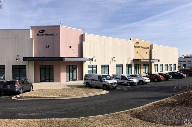
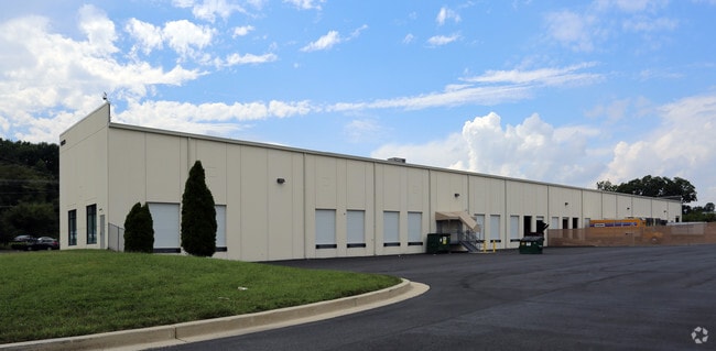
Property Record
8601 Ritchie Dr, Capitol Heights, MD 20743


Save to a Folder
{{folder.Name}}
{{folder.ListingIds.length}} Properties
{{folder.ListingIds.length}} Property
Create a New Folder
Current Lease Availabilities
Property Detail
8601 Ritchie Dr
13-1413046
BUSINESS CENTER- RSB LT 1 BLK B- NM CH CT AMD 2-15-06
Warehouse
PRINCE GEORGE'S
IE
Maryland
B and X Area of moderate flood hazard, usually the area between the limits of the 100-year and 500-year floods.
2
2024
4.58 AC
2025
Capitol Heights
802803
Washington, DC
63,029 SF
Washington-Arlington-Alexandria, DC-VA-MD-WV
NEARBY LISTINGS FOR SALE OR LEASE
DEMOGRAPHICS near 8601 Ritchie Dr
1 mile
3 mile
5 mile
2025 Total Population
4,700
91,072
276,025
2030 Population
4,771
92,399
282,702
Pop Growth 2025-2030
+ 1.51%
+ 1.46%
+ 2.42%
Average Age
42
41
40
2025 Total Households
1,712
35,874
105,260
HH Growth 2025-2030
+ 1.64%
+ 1.61%
+ 2.59%
Median Household Inc
$113,676
$94,674
$90,039
Avg Household Size
2.70
2.50
2.50
2025 Avg HH Vehicles
2.00
2.00
2.00
Median Home Value
$390,508
$354,542
$378,002
Median Year Built
1979
1981
1977
Nearby Places
Map Layers
Map Styles
 Street
 Aerial
Layers
 Traffic
 Biking
Places
Listings with unknown addresses are not visible on the map
- Restaurants
- Banks
- Shops
- Fitness
- Groceries
PUBLIC TRANSPORTATION
COMMUTER RAIL
New Carrollton Amtrak Station (Commuter Rail - Amtrak, Northeast Regional - Amtrak, Palmetto - Amtrak, PENN - WASHINGTON - Amtrak, Vermonter - Amtrak)
Drive
Walk
Distance
New Carrollton Amtrak Station (Commuter Rail - Amtrak, Northeast Regional - Amtrak, Palmetto - Amtrak, PENN - WASHINGTON - Amtrak, Vermonter - Amtrak)
14 min
8.4 mi
New Carrollton Marc Nb (PENN - WASHINGTON - Maryland Transit Administration)
Drive
Walk
Distance
New Carrollton Marc Nb (PENN - WASHINGTON - Maryland Transit Administration)
14 min
8.5 mi
AIRPORT
Ronald Reagan Washington Ntl
Drive
Walk
Distance
Ronald Reagan Washington Ntl
28 min
14.8 mi
Baltimore/Washington International Thurgood Marshall
Drive
Walk
Distance
Baltimore/Washington International Thurgood Marshall
44 min
29.7 mi
Freight Ports
Port of Baltimore
Drive
Walk
Distance
Port of Baltimore
54 min
36.3 mi
Nearby Properties
Address
Land Use
TOTAL SIZE
Lot Size
Zoning
Address
Land Use
TOTAL SIZE
Lot Size
Zoning
35.03 AC
LTOE
Address
Land Use
TOTAL SIZE
Lot Size
Zoning
177,081 SF
23.22 AC
LCD
Address
Land Use
TOTAL SIZE
Lot Size
Zoning
5.10 AC
RTOHC
Address
Land Use
TOTAL SIZE
Lot Size
Zoning
12.60 AC
LTOC
Address
Land Use
TOTAL SIZE
Lot Size
Zoning
129,712 SF
150.08 AC
RR
Address
Land Use
TOTAL SIZE
Lot Size
Zoning
7.72 AC
CGO
Address
Land Use
TOTAL SIZE
Lot Size
Zoning
100 SF
4.78 AC
RTOHC
Address
Land Use
TOTAL SIZE
Lot Size
Zoning
315 SF
6.62 AC
RTOHE
Address
Land Use
TOTAL SIZE
Lot Size
Zoning
386,775 SF
45.40 AC
RMF20
Address
Land Use
TOTAL SIZE
Lot Size
Zoning
456,950 SF
52.92 AC
CGO
Address
Land Use
TOTAL SIZE
Lot Size
Zoning
262 SF
24.86 AC
RMF20
Address
Land Use
TOTAL SIZE
Lot Size
Zoning
344 SF
23.70 AC
RMF12
Address
Land Use
TOTAL SIZE
Lot Size
Zoning
491,397 SF
6.20 AC
RTOHE
Address
Land Use
TOTAL SIZE
Lot Size
Zoning
386,326 SF
62.74 AC
IE
Address
Land Use
TOTAL SIZE
Lot Size
Zoning
9.67 AC
RMF48
Address
Land Use
TOTAL SIZE
Lot Size
Zoning
217,500 SF
12.95 AC
RTOHE
Address
Land Use
TOTAL SIZE
Lot Size
Zoning
34.38 AC
RMF12
Address
Land Use
TOTAL SIZE
Lot Size
Zoning
14.36 AC
RMF48
Address
Land Use
TOTAL SIZE
Lot Size
Zoning
223,600 SF
13.34 AC
IE
Address
Land Use
TOTAL SIZE
Lot Size
Zoning
5.58 AC
CGO
Address
Land Use
TOTAL SIZE
Lot Size
Zoning
259,911 SF
24.14 AC
RTOHE
Address
Land Use
TOTAL SIZE
Lot Size
Zoning
26 SF
9.44 AC
RTOHE
Address
Land Use
TOTAL SIZE
Lot Size
Zoning
219,287 SF
24.46 AC
CGO
Address
Land Use
TOTAL SIZE
Lot Size
Zoning
11.82 AC
RMF20
Address
Land Use
TOTAL SIZE
Lot Size
Zoning
15.65 AC
RMF20
Address
Land Use
TOTAL SIZE
Lot Size
Zoning
182,000 SF
3.69 AC
RTOHE
Address
Land Use
TOTAL SIZE
Lot Size
Zoning
238,785 SF
12.79 AC
CGO
Address
Land Use
TOTAL SIZE
Lot Size
Zoning
125,000 SF
1.03 AC
RTOHC
Address
Land Use
TOTAL SIZE
Lot Size
Zoning
133,840 SF
33.35 AC
IE
Address
Land Use
TOTAL SIZE
Lot Size
Zoning
159,120 SF
10.25 AC
IE
The World's #1 Commercial Real Estate Marketplace
Connect with us
© 2026 CoStar Group
The information above has been obtained from sources believed reliable. While we do not doubt its accuracy we have not verified it and make no guarantee, warranty or representation about it. It is your responsibility to independently confirm its accuracy and completeness. Any projections, opinions, assumptions, or estimates used are for example only and do not represent the current or future performance of the property. The value of this transaction to you depends on tax and other factors which should be evaluated by your tax, financial, and legal advisors. You and your advisors should conduct a careful, independent investigation of the property to determine to your satisfaction the suitability of the property for your needs.