Property Record
861 Callowhill Rd, Perkasie, PA 18944
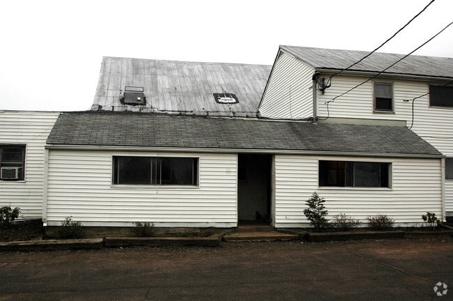

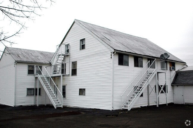

Property Detail
861 Callowhill Rd
15-028-164
5.465AC ES SR4017 502 N OF T417 148 ON CALLOWHIL L RD
Apartment
Bucks
RR
Pennsylvania
B and X Area of moderate flood hazard, usually the area between the limits of the 100-year and 500-year floods.
5.47 AC
2024
Upper Bucks County
2025
Philadelphia
102102
Philadelphia-Camden-Wilmington, PA-NJ-DE-MD
9,064 SF
NEARBY LISTINGS FOR SALE OR LEASE
DEMOGRAPHICS near 861 Callowhill Rd
1 mile
3 mile
5 mile
2025 Total Population
1,484
21,111
72,745
2030 Population
1,484
21,184
73,519
Pop Growth 2025-2030
0.00%
+ 0.35%
+ 1.06%
Average Age
42
42
43
2025 Total Households
499
7,740
27,931
HH Growth 2025-2030
0.00%
+ 0.36%
+ 1.10%
Median Household Inc
$173,417
$123,768
$112,087
Avg Household Size
2.90
2.70
2.60
2025 Avg HH Vehicles
3.00
2.00
2.00
Median Home Value
$671,974
$465,907
$443,740
Median Year Built
1973
1980
1977
Nearby Places
Map Layers
Map Styles
 Street
 Aerial
Layers
 Traffic
 Biking
Places
Listings with unknown addresses are not visible on the map
- Restaurants
- Banks
- Shops
- Fitness
- Groceries
PUBLIC TRANSPORTATION
COMMUTER RAIL
Chalfont (R5 - Southeastern Pennsylvania Transportation Authority Regional Rail (SEPTA Regional Rail))
Drive
Walk
Distance
Chalfont (R5 - Southeastern Pennsylvania Transportation Authority Regional Rail (SEPTA Regional Rail))
11 min
5.7 mi
New Britain (R5 - Southeastern Pennsylvania Transportation Authority Regional Rail (SEPTA Regional Rail))
Drive
Walk
Distance
New Britain (R5 - Southeastern Pennsylvania Transportation Authority Regional Rail (SEPTA Regional Rail))
13 min
5.9 mi
AIRPORT
Lehigh Valley International
Drive
Walk
Distance
Lehigh Valley International
53 min
30.6 mi
Trenton Mercer
Drive
Walk
Distance
Trenton Mercer
53 min
30.9 mi
Freight Ports
Port of Philadelphia
Drive
Walk
Distance
Port of Philadelphia
53 min
31.2 mi
Nearby Properties
Address
Land Use
TOTAL SIZE
Lot Size
Zoning
Address
Land Use
TOTAL SIZE
Lot Size
Zoning
256,512 SF
21.31 AC
CR
Address
Land Use
TOTAL SIZE
Lot Size
Zoning
1,261,187 SF
13.86 AC
CR
Address
Land Use
TOTAL SIZE
Lot Size
Zoning
131,218 SF
14.23 AC
PRD
Address
Land Use
TOTAL SIZE
Lot Size
Zoning
61,589 SF
10.81 AC
C2
Address
Land Use
TOTAL SIZE
Lot Size
Zoning
63,433 SF
8.20 AC
CO
Address
Land Use
TOTAL SIZE
Lot Size
Zoning
13,858 SF
9.62 AC
R1
Address
Land Use
TOTAL SIZE
Lot Size
Zoning
132,250 SF
28.32 AC
RR
Address
Land Use
TOTAL SIZE
Lot Size
Zoning
7.61 AC
CR
Address
Land Use
TOTAL SIZE
Lot Size
Zoning
45,960 SF
0.36 AC
C2
Address
Land Use
TOTAL SIZE
Lot Size
Zoning
55,077 SF
7.22 AC
C2
Address
Land Use
TOTAL SIZE
Lot Size
Zoning
52,819 SF
15.35 AC
CR
Address
Land Use
TOTAL SIZE
Lot Size
Zoning
2,538 SF
4.96 AC
CR
Address
Land Use
TOTAL SIZE
Lot Size
Zoning
12,994 SF
3.89 AC
R2
Address
Land Use
TOTAL SIZE
Lot Size
Zoning
13,600 SF
3.95 AC
R1
Address
Land Use
TOTAL SIZE
Lot Size
Zoning
2,300 SF
73.49 AC
Q
Address
Land Use
TOTAL SIZE
Lot Size
Zoning
41,460 SF
4.90 AC
R1
Address
Land Use
TOTAL SIZE
Lot Size
Zoning
35,200 SF
2.54 AC
C2
Address
Land Use
TOTAL SIZE
Lot Size
Zoning
9,680 SF
57.74 AC
Q
Address
Land Use
TOTAL SIZE
Lot Size
Zoning
5,525 SF
2.57 AC
PC2
Address
Land Use
TOTAL SIZE
Lot Size
Zoning
14,601 SF
1.84 AC
C2
Address
Land Use
TOTAL SIZE
Lot Size
Zoning
16,520 SF
3.38 AC
R1
Address
Land Use
TOTAL SIZE
Lot Size
Zoning
12,859 SF
2.19 AC
PC2
Address
Land Use
TOTAL SIZE
Lot Size
Zoning
82,313 SF
4.41 AC
R3
Address
Land Use
TOTAL SIZE
Lot Size
Zoning
17,200 SF
2.04 AC
R1
Address
Land Use
TOTAL SIZE
Lot Size
Zoning
42,360 SF
4.42 AC
PC2
Address
Land Use
TOTAL SIZE
Lot Size
Zoning
15,603 SF
9.71 AC
R1
Address
Land Use
TOTAL SIZE
Lot Size
Zoning
23,718 SF
23.10 AC
RR
Address
Land Use
TOTAL SIZE
Lot Size
Zoning
10,000 SF
3.20 AC
PC2
Address
Land Use
TOTAL SIZE
Lot Size
Zoning
17,760 SF
1.34 AC
R1
Address
Land Use
TOTAL SIZE
Lot Size
Zoning
2,900 SF
0.08 AC
C2
The World's #1 Commercial Real Estate Marketplace
Connect with us
© 2026 CoStar Group
The information above has been obtained from sources believed reliable. While we do not doubt its accuracy we have not verified it and make no guarantee, warranty or representation about it. It is your responsibility to independently confirm its accuracy and completeness. Any projections, opinions, assumptions, or estimates used are for example only and do not represent the current or future performance of the property. The value of this transaction to you depends on tax and other factors which should be evaluated by your tax, financial, and legal advisors. You and your advisors should conduct a careful, independent investigation of the property to determine to your satisfaction the suitability of the property for your needs.