Property Record
8610 State Route 339, Vincent, OH 45784
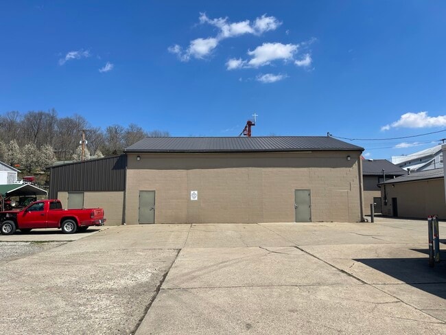

This Property Is For Sale
NEARBY LISTINGS FOR SALE OR LEASE
-
-
View all Vincent listings for sale on LoopNet.com
Property Detail
8610 State Route 339
0500-13036-000
R10 T3 S21 160 AC LOT 102 8 & PT VILLAGE LOT 20 .40 AC
Autorepair
Washington
A
Ohio
39167C0225F
1028
2024
0.40 AC
2024
Ohio South Area
021700
Other Market Areas
2,000 SF
Marietta, OH
DEMOGRAPHICS near 8610 State Route 339
1 Mile
3 Mile
5 Mile
2024 Total Population
441
2,181
4,886
2029 Population
413
2,044
4,616
Pop Growth 2024-2029
(6.35%)
(6.28%)
(5.53%)
Average Age
44
44
43
2024 Total Households
173
855
1,885
HH Growth 2024-2029
(6.94%)
(6.55%)
(5.68%)
Median Household Inc
$64,038
$64,629
$72,068
Avg Household Size
2.50
2.50
2.60
2024 Avg HH Vehicles
2.00
2.00
2.00
Median Home Value
$220,968
$218,197
$191,666
Median Year Built
1987
1986
1983
Nearby Places
Map Layers
Map Styles
 Street
 Aerial
- Restaurants
- Banks
- Shops
- Fitness
- Groceries
Nearby Properties
Address
Land Use
TOTAL SIZE
Lot Size
Zoning
Address
Land Use
TOTAL SIZE
Lot Size
Zoning
64,976 SF
56.86 AC
Address
Land Use
TOTAL SIZE
Lot Size
Zoning
49,426 SF
7.44 AC
Address
Land Use
TOTAL SIZE
Lot Size
Zoning
5,824 SF
2.19 AC
Address
Land Use
TOTAL SIZE
Lot Size
Zoning
9,408 SF
37.27 AC
Address
Land Use
TOTAL SIZE
Lot Size
Zoning
12,444 SF
0.94 AC
Address
Land Use
TOTAL SIZE
Lot Size
Zoning
12,254 SF
1.01 AC
Address
Land Use
TOTAL SIZE
Lot Size
Zoning
13,320 SF
0.74 AC
Address
Land Use
TOTAL SIZE
Lot Size
Zoning
6,600 SF
13.52 AC
Address
Land Use
TOTAL SIZE
Lot Size
Zoning
3,268 SF
1.53 AC
Address
Land Use
TOTAL SIZE
Lot Size
Zoning
13,265 SF
2.77 AC
Address
Land Use
TOTAL SIZE
Lot Size
Zoning
9,180 SF
0.67 AC
Address
Land Use
TOTAL SIZE
Lot Size
Zoning
780 SF
7.54 AC
Address
Land Use
TOTAL SIZE
Lot Size
Zoning
9,000 SF
0.56 AC
Address
Land Use
TOTAL SIZE
Lot Size
Zoning
187 SF
12.02 AC
Address
Land Use
TOTAL SIZE
Lot Size
Zoning
5,180 SF
0.84 AC
Address
Land Use
TOTAL SIZE
Lot Size
Zoning
144.21 AC
Address
Land Use
TOTAL SIZE
Lot Size
Zoning
Address
Land Use
TOTAL SIZE
Lot Size
Zoning
2,556 SF
137.63 AC
Address
Land Use
TOTAL SIZE
Lot Size
Zoning
139.80 AC
Address
Land Use
TOTAL SIZE
Lot Size
Zoning
6,152 SF
4.02 AC
Address
Land Use
TOTAL SIZE
Lot Size
Zoning
8.73 AC
Address
Land Use
TOTAL SIZE
Lot Size
Zoning
1,810 SF
0.84 AC
Address
Land Use
TOTAL SIZE
Lot Size
Zoning
3,472 SF
0.98 AC
Address
Land Use
TOTAL SIZE
Lot Size
Zoning
3,964 SF
0.61 AC
Address
Land Use
TOTAL SIZE
Lot Size
Zoning
2,640 SF
17.51 AC
Address
Land Use
TOTAL SIZE
Lot Size
Zoning
11.92 AC
Address
Land Use
TOTAL SIZE
Lot Size
Zoning
88.52 AC
Address
Land Use
TOTAL SIZE
Lot Size
Zoning
4,644 SF
1.50 AC
Address
Land Use
TOTAL SIZE
Lot Size
Zoning
83.10 AC
Address
Land Use
TOTAL SIZE
Lot Size
Zoning
8,040 SF
25.11 AC
The World's #1 Commercial Real Estate Marketplace
Connect with us
© 2025 CoStar Group
The information above has been obtained from sources believed reliable. While we do not doubt its accuracy we have not verified it and make no guarantee, warranty or representation about it. It is your responsibility to independently confirm its accuracy and completeness. Any projections, opinions, assumptions, or estimates used are for example only and do not represent the current or future performance of the property. The value of this transaction to you depends on tax and other factors which should be evaluated by your tax, financial, and legal advisors. You and your advisors should conduct a careful, independent investigation of the property to determine to your satisfaction the suitability of the property for your needs.