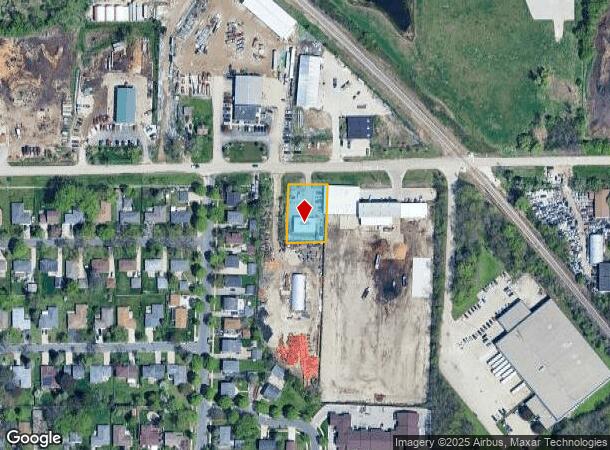
Property Record
8613 W Calumet Rd, Milwaukee, WI 53224
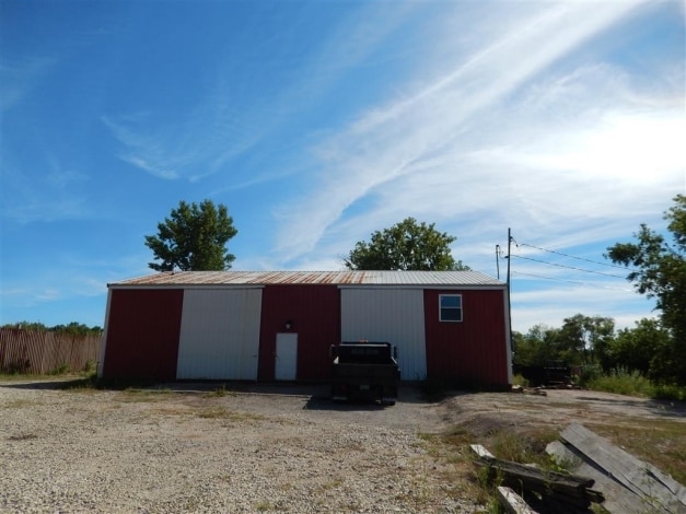
This Property Is For Sale
NEARBY LISTINGS FOR SALE OR LEASE
Property Detail
8613 W Calumet Rd
108-9997-000-X
LANDS IN SW 1/4 SEC 16-8-21 E 110 OF N 200 OF W 1/4 OF NE 1/4 OF SD 1/4 SEC (GOVT LOT 11) EXC ST BID #48
Warehouse
Milwaukee
X
Wisconsin
55089C0245G
11
2024
0.42 AC
2024
Milwaukee NW
000102
Milwaukee/Madison
2,400 SF
Milwaukee-Waukesha-West Allis, WI
DEMOGRAPHICS near 8613 W Calumet Rd
1 Mile
3 Mile
5 Mile
2024 Total Population
5,375
76,970
194,307
2029 Population
5,245
75,509
191,880
Pop Growth 2024-2029
(2.42%)
(1.90%)
(1.25%)
Average Age
37
37
38
2024 Total Households
1,980
29,637
76,809
HH Growth 2024-2029
(2.53%)
(2.03%)
(1.31%)
Median Household Inc
$77,547
$53,113
$55,354
Avg Household Size
2.60
2.50
2.40
2024 Avg HH Vehicles
2.00
1.00
2.00
Median Home Value
$180,849
$164,050
$181,650
Median Year Built
1977
1969
1963
Nearby Places
- Restaurants
- Banks
- Shops
- Fitness
- Groceries
PUBLIC TRANSPORTATION
AIRPORT
General Mitchell International
DRIVE
WALK
Distance
General Mitchell International
36 min
20.8 mi
Freight Ports
Port Milwaukee
DRIVE
WALK
Distance
Port Milwaukee
28 min
16.6 mi
Nearby Properties
Address
Land Use
TOTAL SIZE
Lot Size
Zoning
Address
Land Use
TOTAL SIZE
Lot Size
Zoning
369,652 SF
20 AC
Address
Land Use
TOTAL SIZE
Lot Size
Zoning
121,472 SF
8.97 AC
Address
Land Use
TOTAL SIZE
Lot Size
Zoning
33.49 AC
TL
Address
Land Use
TOTAL SIZE
Lot Size
Zoning
222,355 SF
4.32 AC
Address
Land Use
TOTAL SIZE
Lot Size
Zoning
391,696 SF
36.33 AC
PD
Address
Land Use
TOTAL SIZE
Lot Size
Zoning
530,458 SF
26.32 AC
Address
Land Use
TOTAL SIZE
Lot Size
Zoning
197,426 SF
26.34 AC
PD
Address
Land Use
TOTAL SIZE
Lot Size
Zoning
206,529 SF
7.88 AC
PD
Address
Land Use
TOTAL SIZE
Lot Size
Zoning
13,717 SF
21.84 AC
IL1
Address
Land Use
TOTAL SIZE
Lot Size
Zoning
292,944 SF
17.32 AC
Address
Land Use
TOTAL SIZE
Lot Size
Zoning
245,266 SF
18.11 AC
PD
Address
Land Use
TOTAL SIZE
Lot Size
Zoning
298,666 SF
5.09 AC
PD
Address
Land Use
TOTAL SIZE
Lot Size
Zoning
209,138 SF
14.70 AC
Address
Land Use
TOTAL SIZE
Lot Size
Zoning
326,619 SF
30.69 AC
PD
Address
Land Use
TOTAL SIZE
Lot Size
Zoning
160,000 SF
12.48 AC
Address
Land Use
TOTAL SIZE
Lot Size
Zoning
12.49 AC
TL
Address
Land Use
TOTAL SIZE
Lot Size
Zoning
241,880 SF
17.39 AC
Address
Land Use
TOTAL SIZE
Lot Size
Zoning
104,365 SF
9.85 AC
PD
Address
Land Use
TOTAL SIZE
Lot Size
Zoning
4.70 AC
Address
Land Use
TOTAL SIZE
Lot Size
Zoning
Address
Land Use
TOTAL SIZE
Lot Size
Zoning
378,511 SF
22.19 AC
Address
Land Use
TOTAL SIZE
Lot Size
Zoning
427 SF
35.16 AC
IL1
Address
Land Use
TOTAL SIZE
Lot Size
Zoning
419,659 SF
33.55 AC
IL1
Address
Land Use
TOTAL SIZE
Lot Size
Zoning
140,757 SF
19.08 AC
PD
Address
Land Use
TOTAL SIZE
Lot Size
Zoning
93.72 AC
PK
Address
Land Use
TOTAL SIZE
Lot Size
Zoning
225,174 SF
6.68 AC
Address
Land Use
TOTAL SIZE
Lot Size
Zoning
136,544 SF
11.32 AC
Address
Land Use
TOTAL SIZE
Lot Size
Zoning
Address
Land Use
TOTAL SIZE
Lot Size
Zoning
21,516 SF
11.86 AC
IL1
Address
Land Use
TOTAL SIZE
Lot Size
Zoning
364,373 SF
61.40 AC
IL1
The World's #1 Commercial Real Estate Marketplace
Connect with us
© 2025 CoStar Group
The information above has been obtained from sources believed reliable. While we do not doubt its accuracy we have not verified it and make no guarantee, warranty or representation about it. It is your responsibility to independently confirm its accuracy and completeness. Any projections, opinions, assumptions, or estimates used are for example only and do not represent the current or future performance of the property. The value of this transaction to you depends on tax and other factors which should be evaluated by your tax, financial, and legal advisors. You and your advisors should conduct a careful, independent investigation of the property to determine to your satisfaction the suitability of the property for your needs.