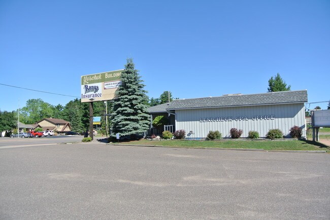
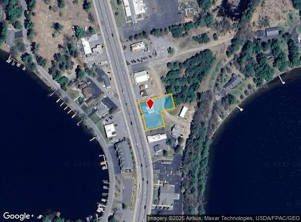
Property Record
8618 Ush 51 N, Minocqua, WI 54548
NEARBY LISTINGS FOR SALE OR LEASE
Property Detail
8618 Ush 51 N
MI 2178 34
DOC 850943/847682 PT G L 5.52CA/-SA UNRCD MINOC-WOOD EXC HWY ROW INCL PT LOT 2 CSM V5-P1329 3 DESC DOC 850943
Commercialnec
Oneida
X
Wisconsin
55085C0090C
2
2024
0.53 AC
2024
Wisconsin North Area
971300
Other Market Areas
DEMOGRAPHICS near 8618 Ush 51 N
1 Mile
3 Mile
5 Mile
2024 Total Population
862
5,654
8,403
2029 Population
860
5,865
8,732
Pop Growth 2024-2029
(0.23%)
+ 3.73%
+ 3.92%
Average Age
51
49
49
2024 Total Households
480
2,744
3,964
HH Growth 2024-2029
(0.42%)
+ 3.21%
+ 3.53%
Median Household Inc
$52,500
$73,918
$73,089
Avg Household Size
1.80
2.00
2.00
2024 Avg HH Vehicles
1.00
2.00
2.00
Median Home Value
$258,955
$254,127
$251,328
Median Year Built
1987
1987
1988
Nearby Places
Map Layers
Map Styles
 Street
 Aerial
- Restaurants
- Banks
- Shops
- Fitness
- Groceries
SALE & LEASE HISTORY
LISTING DATE
SALE/LEASE

Jul 13, 2020
For Sale
Feb 27, 2018
For Sale
Nearby Properties
Address
Land Use
TOTAL SIZE
Lot Size
Zoning
Address
Land Use
TOTAL SIZE
Lot Size
Zoning
37.55 AC
Address
Land Use
TOTAL SIZE
Lot Size
Zoning
19.73 AC
Address
Land Use
TOTAL SIZE
Lot Size
Zoning
Address
Land Use
TOTAL SIZE
Lot Size
Zoning
18.78 AC
Address
Land Use
TOTAL SIZE
Lot Size
Zoning
Address
Land Use
TOTAL SIZE
Lot Size
Zoning
11.89 AC
Address
Land Use
TOTAL SIZE
Lot Size
Zoning
Address
Land Use
TOTAL SIZE
Lot Size
Zoning
Address
Land Use
TOTAL SIZE
Lot Size
Zoning
8.99 AC
Address
Land Use
TOTAL SIZE
Lot Size
Zoning
46.42 AC
Address
Land Use
TOTAL SIZE
Lot Size
Zoning
3.04 AC
Address
Land Use
TOTAL SIZE
Lot Size
Zoning
15.42 AC
Address
Land Use
TOTAL SIZE
Lot Size
Zoning
4.19 AC
Address
Land Use
TOTAL SIZE
Lot Size
Zoning
3.12 AC
Address
Land Use
TOTAL SIZE
Lot Size
Zoning
3.33 AC
Address
Land Use
TOTAL SIZE
Lot Size
Zoning
Address
Land Use
TOTAL SIZE
Lot Size
Zoning
0.39 AC
Address
Land Use
TOTAL SIZE
Lot Size
Zoning
3.43 AC
Address
Land Use
TOTAL SIZE
Lot Size
Zoning
1.01 AC
Address
Land Use
TOTAL SIZE
Lot Size
Zoning
0.94 AC
Address
Land Use
TOTAL SIZE
Lot Size
Zoning
1.99 AC
Address
Land Use
TOTAL SIZE
Lot Size
Zoning
3.03 AC
Address
Land Use
TOTAL SIZE
Lot Size
Zoning
1.43 AC
Address
Land Use
TOTAL SIZE
Lot Size
Zoning
7.35 AC
Address
Land Use
TOTAL SIZE
Lot Size
Zoning
30.20 AC
Address
Land Use
TOTAL SIZE
Lot Size
Zoning
30.69 AC
Address
Land Use
TOTAL SIZE
Lot Size
Zoning
49.46 AC
Address
Land Use
TOTAL SIZE
Lot Size
Zoning
11.10 AC
Address
Land Use
TOTAL SIZE
Lot Size
Zoning
5.78 AC
Address
Land Use
TOTAL SIZE
Lot Size
Zoning
0.58 AC
The World's #1 Commercial Real Estate Marketplace
Connect with us
© 2025 CoStar Group
The information above has been obtained from sources believed reliable. While we do not doubt its accuracy we have not verified it and make no guarantee, warranty or representation about it. It is your responsibility to independently confirm its accuracy and completeness. Any projections, opinions, assumptions, or estimates used are for example only and do not represent the current or future performance of the property. The value of this transaction to you depends on tax and other factors which should be evaluated by your tax, financial, and legal advisors. You and your advisors should conduct a careful, independent investigation of the property to determine to your satisfaction the suitability of the property for your needs.