Property Record
862 N Quidnessett Rd, North Kingstown, RI 02852
NEARBY LISTINGS FOR SALE OR LEASE
-
-
View all North Kingstown listings for sale on LoopNet.com
Property Detail
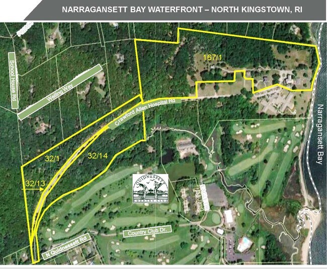
862 N Quidnessett Rd
NKIN M:167 B:001
Washington
Religious
Rhode Island
AE
39.12 AC
44009C0018J
Washington County
2025
Providence
2025
Providence-Warwick, RI-MA
050102
DEMOGRAPHICS near 862 N Quidnessett Rd
1 Mile
3 Mile
5 Mile
2024 Total Population
1,204
14,752
66,394
2029 Population
1,196
14,784
67,093
Pop Growth 2024-2029
(0.66%)
+ 0.22%
+ 1.05%
Average Age
46
46
44
2024 Total Households
471
6,543
28,391
HH Growth 2024-2029
(0.85%)
+ 0.17%
+ 0.98%
Median Household Inc
$121,773
$105,433
$83,444
Avg Household Size
2.50
2.20
2.30
2024 Avg HH Vehicles
2.00
2.00
2.00
Median Home Value
$455,909
$436,334
$358,447
Median Year Built
1965
1960
1966
Nearby Places
Map Layers
Map Styles
 Street
 Aerial
- Restaurants
- Banks
- Shops
- Fitness
- Groceries
PUBLIC TRANSPORTATION
COMMUTER RAIL
Tf Green Airport (Providence/Stoughton Line - MBTA)
DRIVE
WALK
Distance
Tf Green Airport (Providence/Stoughton Line - MBTA)
24 min
9.2 mi
Wickford Junction (Providence/Stoughton Line - MBTA)
DRIVE
WALK
Distance
Wickford Junction (Providence/Stoughton Line - MBTA)
24 min
9.6 mi
AIRPORT
Rhode Island Tf Green International
DRIVE
WALK
Distance
Rhode Island Tf Green International
30 min
11.5 mi
Freight Ports
Port of Davisville, RI
DRIVE
WALK
Distance
Port of Davisville, RI
21 min
7.4 mi
SALE & LEASE HISTORY
LISTING DATE
SALE/LEASE

Sep 14, 2023
For Sale
Nearby Properties
Address
Land Use
TOTAL SIZE
Lot Size
Zoning
Address
Land Use
TOTAL SIZE
Lot Size
Zoning
28,800 SF
18.70 AC
QBPD
Address
Land Use
TOTAL SIZE
Lot Size
Zoning
10,375 SF
75.99 AC
A10
Address
Land Use
TOTAL SIZE
Lot Size
Zoning
107,212 SF
18.50 AC
R10
Address
Land Use
TOTAL SIZE
Lot Size
Zoning
18.60 AC
QBPD
Address
Land Use
TOTAL SIZE
Lot Size
Zoning
9,216 SF
A7
Address
Land Use
TOTAL SIZE
Lot Size
Zoning
65,780 SF
16.20 AC
QBPD
Address
Land Use
TOTAL SIZE
Lot Size
Zoning
4,622 SF
473.27 AC
OS
Address
Land Use
TOTAL SIZE
Lot Size
Zoning
5.31 AC
R10
Address
Land Use
TOTAL SIZE
Lot Size
Zoning
6.90 AC
QBPD
Address
Land Use
TOTAL SIZE
Lot Size
Zoning
87,968 SF
5.22 AC
R10
Address
Land Use
TOTAL SIZE
Lot Size
Zoning
3.69 AC
CD1
Address
Land Use
TOTAL SIZE
Lot Size
Zoning
91,074 SF
QBPD
Address
Land Use
TOTAL SIZE
Lot Size
Zoning
93.60 AC
QBPD
Address
Land Use
TOTAL SIZE
Lot Size
Zoning
58,568 SF
5.21 AC
A15
Address
Land Use
TOTAL SIZE
Lot Size
Zoning
44,621 SF
25.61 AC
P
Address
Land Use
TOTAL SIZE
Lot Size
Zoning
32,791 SF
112.84 AC
A40
Address
Land Use
TOTAL SIZE
Lot Size
Zoning
73,420 SF
1.23 AC
CD2
Address
Land Use
TOTAL SIZE
Lot Size
Zoning
60,380 SF
19.80 AC
RRUL
Address
Land Use
TOTAL SIZE
Lot Size
Zoning
71.54 AC
RR
Address
Land Use
TOTAL SIZE
Lot Size
Zoning
Address
Land Use
TOTAL SIZE
Lot Size
Zoning
333,149 SF
Address
Land Use
TOTAL SIZE
Lot Size
Zoning
31,534 SF
10 AC
P
Address
Land Use
TOTAL SIZE
Lot Size
Zoning
76,750 SF
8.49 AC
CH
Address
Land Use
TOTAL SIZE
Lot Size
Zoning
Address
Land Use
TOTAL SIZE
Lot Size
Zoning
21,126 SF
1.99 AC
Address
Land Use
TOTAL SIZE
Lot Size
Zoning
17,888 SF
0.87 AC
CD1
Address
Land Use
TOTAL SIZE
Lot Size
Zoning
38,784 SF
1.84 AC
R10
Address
Land Use
TOTAL SIZE
Lot Size
Zoning
39.35 AC
QBPD
Address
Land Use
TOTAL SIZE
Lot Size
Zoning
6,025 SF
2.95 AC
A40
The World's #1 Commercial Real Estate Marketplace
Connect with us
© 2026 CoStar Group
The information above has been obtained from sources believed reliable. While we do not doubt its accuracy we have not verified it and make no guarantee, warranty or representation about it. It is your responsibility to independently confirm its accuracy and completeness. Any projections, opinions, assumptions, or estimates used are for example only and do not represent the current or future performance of the property. The value of this transaction to you depends on tax and other factors which should be evaluated by your tax, financial, and legal advisors. You and your advisors should conduct a careful, independent investigation of the property to determine to your satisfaction the suitability of the property for your needs.