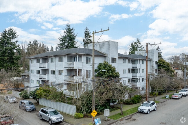
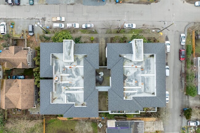
Property Record
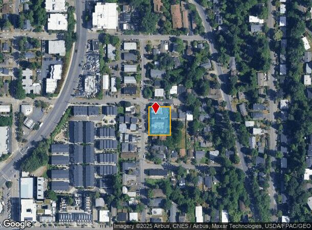
8620 23Rd Ave Ne, Seattle, WA 98115
NEARBY LISTINGS FOR SALE OR LEASE
Property Detail
8620 23Rd Ave Ne
Seattle-Tacoma-Bellevue, WA
Maple Leaf To Green Lake Circle Por Of
510140-0632
MAPLE LEAF TO GREEN LAKE CIRCLE VAC
Apartment
King
X
Washington
53033C0333G
1-3ac
2025
0.37 AC
2024
Wedgewood
002100
Seattle/Puget Sound
22,585 SF
DEMOGRAPHICS near 8620 23Rd Ave Ne
1 Mile
3 Mile
5 Mile
2024 Total Population
25,808
216,097
474,396
2029 Population
25,881
218,430
479,470
Pop Growth 2024-2029
+ 0.28%
+ 1.08%
+ 1.07%
Average Age
39
37
38
2024 Total Households
10,337
93,043
214,873
HH Growth 2024-2029
+ 0.13%
+ 1.15%
+ 1.08%
Median Household Inc
$156,316
$105,858
$118,298
Avg Household Size
2.40
2.10
2.10
2024 Avg HH Vehicles
2.00
1.00
1.00
Median Home Value
$934,029
$916,899
$919,376
Median Year Built
1951
1969
1972
Nearby Places
Map Layers
Map Styles
 Street
 Aerial
- Restaurants
- Banks
- Shops
- Fitness
- Groceries
PUBLIC TRANSPORTATION
COMMUTER RAIL
King Street (Seattle) Station (Everett - Seattle - Sound Transit, Seattle - Tacoma/Lakewood - Sound Transit, Sounder South Line - Sound Transit)
DRIVE
WALK
Distance
King Street (Seattle) Station (Everett - Seattle - Sound Transit, Seattle - Tacoma/Lakewood - Sound Transit, Sounder South Line - Sound Transit)
12 min
7.2 mi
AIRPORT
Seattle Paine Field International
DRIVE
WALK
Distance
Seattle Paine Field International
29 min
19.0 mi
Seattle-Tacoma International
DRIVE
WALK
Distance
Seattle-Tacoma International
31 min
20.5 mi
Freight Ports
Port of Seattle
DRIVE
WALK
Distance
Port of Seattle
18 min
11.0 mi
Nearby Properties
Address
Land Use
TOTAL SIZE
Lot Size
Zoning
Address
Land Use
TOTAL SIZE
Lot Size
Zoning
471.20 AC
MIO-37-LR1
Address
Land Use
TOTAL SIZE
Lot Size
Zoning
26,850 SF
194.66 AC
NR2
Address
Land Use
TOTAL SIZE
Lot Size
Zoning
107.86 AC
NR2
Address
Land Use
TOTAL SIZE
Lot Size
Zoning
50,060 SF
96.12 AC
NR2
Address
Land Use
TOTAL SIZE
Lot Size
Zoning
7,549 SF
59.34 AC
MIO-105-LR
Address
Land Use
TOTAL SIZE
Lot Size
Zoning
612,844 SF
0.09 AC
SM-U/R 75-
Address
Land Use
TOTAL SIZE
Lot Size
Zoning
90,184 SF
16.66 AC
C1-75 (M)
Address
Land Use
TOTAL SIZE
Lot Size
Zoning
107.93 AC
NR3
Address
Land Use
TOTAL SIZE
Lot Size
Zoning
42,500 SF
90.92 AC
NR3
Address
Land Use
TOTAL SIZE
Lot Size
Zoning
301,245 SF
22.34 AC
LR3 (M)
Address
Land Use
TOTAL SIZE
Lot Size
Zoning
25,735 SF
1.56 AC
C1-75 (M)
Address
Land Use
TOTAL SIZE
Lot Size
Zoning
285,140 SF
0.90 AC
NC2-75 (M1
Address
Land Use
TOTAL SIZE
Lot Size
Zoning
131,790 SF
0.37 AC
SM-U 75-24
Address
Land Use
TOTAL SIZE
Lot Size
Zoning
6.87 AC
MIO-200-C1
Address
Land Use
TOTAL SIZE
Lot Size
Zoning
126,394 SF
8.80 AC
C2-75 (M)
Address
Land Use
TOTAL SIZE
Lot Size
Zoning
223,047 SF
0.18 AC
NC2P-75 (M
Address
Land Use
TOTAL SIZE
Lot Size
Zoning
382,762 SF
7.14 AC
NR3
Address
Land Use
TOTAL SIZE
Lot Size
Zoning
172,297 SF
4.21 AC
NC3-95 (M)
Address
Land Use
TOTAL SIZE
Lot Size
Zoning
0.31 AC
SM-U 95-32
Address
Land Use
TOTAL SIZE
Lot Size
Zoning
10,090 SF
11.73 AC
NC3-95 (M)
Address
Land Use
TOTAL SIZE
Lot Size
Zoning
132,183 SF
0.76 AC
NC2-65
Address
Land Use
TOTAL SIZE
Lot Size
Zoning
6,534 SF
0.55 AC
IC-65 (M)
Address
Land Use
TOTAL SIZE
Lot Size
Zoning
162,182 SF
9.10 AC
LR2 (M)
Address
Land Use
TOTAL SIZE
Lot Size
Zoning
205,000 SF
13.89 AC
NR3
Address
Land Use
TOTAL SIZE
Lot Size
Zoning
215,468 SF
0.60 AC
NC2-75 (M1
Address
Land Use
TOTAL SIZE
Lot Size
Zoning
2,874 SF
21.94 AC
NR3
Address
Land Use
TOTAL SIZE
Lot Size
Zoning
160,593 SF
1.57 AC
NC3P-75 (M
Address
Land Use
TOTAL SIZE
Lot Size
Zoning
184,251 SF
10.02 AC
LR3 (M)
The World's #1 Commercial Real Estate Marketplace
Connect with us
© 2025 CoStar Group
The information above has been obtained from sources believed reliable. While we do not doubt its accuracy we have not verified it and make no guarantee, warranty or representation about it. It is your responsibility to independently confirm its accuracy and completeness. Any projections, opinions, assumptions, or estimates used are for example only and do not represent the current or future performance of the property. The value of this transaction to you depends on tax and other factors which should be evaluated by your tax, financial, and legal advisors. You and your advisors should conduct a careful, independent investigation of the property to determine to your satisfaction the suitability of the property for your needs.