Property Record
8620 Algoma Ave Ne, Rockford, MI 49341

NEARBY LISTINGS FOR SALE OR LEASE
-
-
View all Rockford listings for sale on LoopNet.com
Property Detail
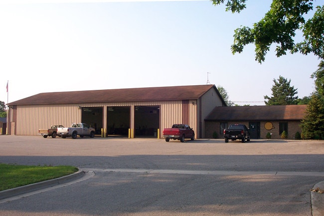
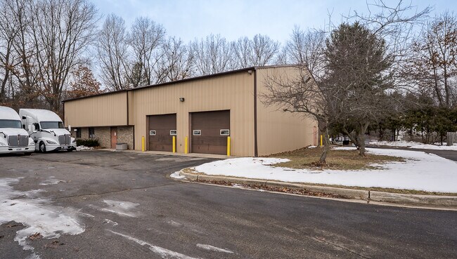
8620 Algoma Ave Ne
41-06-34-300-034
PART OF NW 1/4 SW 1/4 COM AT W 1/4 COR TH S 0D 00M 16S E ALONG W SEC LINE 993.0 FT TO S LINE OF N 993.0 FT OF NW 1/4 SW 1/4
Commercialnec
Kent
X
Michigan
26081C0301D
5.87 AC
2024
Outlying Kent County
2025
West Michigan
010602
Grand Rapids-Wyoming, MI
1,440 SF
DEMOGRAPHICS near 8620 Algoma Ave Ne
1 Mile
3 Mile
5 Mile
2024 Total Population
1,901
17,742
45,022
2029 Population
1,953
17,984
45,545
Pop Growth 2024-2029
+ 2.74%
+ 1.36%
+ 1.16%
Average Age
38
39
40
2024 Total Households
686
6,435
16,426
HH Growth 2024-2029
+ 2.77%
+ 1.37%
+ 1.15%
Median Household Inc
$99,679
$100,133
$97,041
Avg Household Size
2.70
2.70
2.70
2024 Avg HH Vehicles
2.00
2.00
2.00
Median Home Value
$330,294
$291,231
$284,660
Median Year Built
2009
1992
1989
Nearby Places
Map Layers
Map Styles
 Street
 Aerial
- Restaurants
- Banks
- Shops
- Fitness
- Groceries
PUBLIC TRANSPORTATION
AIRPORT
Gerald R Ford International
DRIVE
WALK
Distance
Gerald R Ford International
35 min
25.4 mi
SALE & LEASE HISTORY
LISTING DATE
SALE/LEASE

Mar 21, 2025
For Sale
Aug 08, 2017
For Sale
Nearby Properties
Address
Land Use
TOTAL SIZE
Lot Size
Zoning
Address
Land Use
TOTAL SIZE
Lot Size
Zoning
32.53 AC
Address
Land Use
TOTAL SIZE
Lot Size
Zoning
22.40 AC
Address
Land Use
TOTAL SIZE
Lot Size
Zoning
128,148 SF
42.93 AC
PUD
Address
Land Use
TOTAL SIZE
Lot Size
Zoning
17.30 AC
Address
Land Use
TOTAL SIZE
Lot Size
Zoning
4.51 AC
Address
Land Use
TOTAL SIZE
Lot Size
Zoning
97.71 AC
Address
Land Use
TOTAL SIZE
Lot Size
Zoning
97.84 AC
Address
Land Use
TOTAL SIZE
Lot Size
Zoning
53.97 AC
Address
Land Use
TOTAL SIZE
Lot Size
Zoning
79.34 AC
Address
Land Use
TOTAL SIZE
Lot Size
Zoning
9.88 AC
Address
Land Use
TOTAL SIZE
Lot Size
Zoning
10.08 AC
Address
Land Use
TOTAL SIZE
Lot Size
Zoning
11.26 AC
Address
Land Use
TOTAL SIZE
Lot Size
Zoning
10.12 AC
Address
Land Use
TOTAL SIZE
Lot Size
Zoning
6.51 AC
Address
Land Use
TOTAL SIZE
Lot Size
Zoning
10.61 AC
Address
Land Use
TOTAL SIZE
Lot Size
Zoning
64,075 SF
11.13 AC
I-1
Address
Land Use
TOTAL SIZE
Lot Size
Zoning
18,630 SF
1.84 AC
C2
Address
Land Use
TOTAL SIZE
Lot Size
Zoning
17.70 AC
Address
Land Use
TOTAL SIZE
Lot Size
Zoning
Address
Land Use
TOTAL SIZE
Lot Size
Zoning
2.28 AC
Address
Land Use
TOTAL SIZE
Lot Size
Zoning
3.62 AC
Address
Land Use
TOTAL SIZE
Lot Size
Zoning
49,647 SF
5.30 AC
I-1
Address
Land Use
TOTAL SIZE
Lot Size
Zoning
64,632 SF
3.75 AC
I-1
Address
Land Use
TOTAL SIZE
Lot Size
Zoning
2.96 AC
Address
Land Use
TOTAL SIZE
Lot Size
Zoning
75,000 SF
6.60 AC
I-1
Address
Land Use
TOTAL SIZE
Lot Size
Zoning
Address
Land Use
TOTAL SIZE
Lot Size
Zoning
3.15 AC
Address
Land Use
TOTAL SIZE
Lot Size
Zoning
8.72 AC
Address
Land Use
TOTAL SIZE
Lot Size
Zoning
54,186 SF
3.17 AC
I-1
Address
Land Use
TOTAL SIZE
Lot Size
Zoning
1,548 SF
49.71 AC
The World's #1 Commercial Real Estate Marketplace
Connect with us
© 2025 CoStar Group
The information above has been obtained from sources believed reliable. While we do not doubt its accuracy we have not verified it and make no guarantee, warranty or representation about it. It is your responsibility to independently confirm its accuracy and completeness. Any projections, opinions, assumptions, or estimates used are for example only and do not represent the current or future performance of the property. The value of this transaction to you depends on tax and other factors which should be evaluated by your tax, financial, and legal advisors. You and your advisors should conduct a careful, independent investigation of the property to determine to your satisfaction the suitability of the property for your needs.