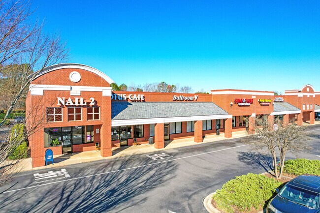
Property Record
8610 Camfield St, Charlotte, NC 28277
NEARBY LISTINGS FOR SALE OR LEASE
Property Detail
8610 Camfield St
Charlotte-Concord-Gastonia, NC-SC
Ballantyne Commons Pkwy Elm Lane Inter S
223-284-31
M26-13, M36-375
Commercialnec
Mecklenburg
X
North Carolina
45057C0040E
31
2024
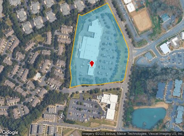
9.70 AC
2025
Outer Southeast
005859
Charlotte
70,171 SF
DEMOGRAPHICS near 8610 Camfield St
1 Mile
3 Mile
5 Mile
2024 Total Population
11,371
85,995
178,248
2029 Population
11,921
90,367
190,621
Pop Growth 2024-2029
+ 4.84%
+ 5.08%
+ 6.94%
Average Age
41
39
39
2024 Total Households
4,776
33,397
68,036
HH Growth 2024-2029
+ 4.88%
+ 5.12%
+ 6.84%
Median Household Inc
$98,685
$120,133
$117,259
Avg Household Size
2.40
2.50
2.60
2024 Avg HH Vehicles
2.00
2.00
2.00
Median Home Value
$406,746
$458,188
$460,508
Median Year Built
1997
1999
1997
Nearby Places
Map Layers
Map Styles
 Street
 Aerial
- Restaurants
- Banks
- Shops
- Fitness
- Groceries
PUBLIC TRANSPORTATION
AIRPORT
Charlotte/Douglas International
DRIVE
WALK
Distance
Charlotte/Douglas International
27 min
16.5 mi
Concord-Padgett Regional
DRIVE
WALK
Distance
Concord-Padgett Regional
42 min
34.1 mi
Freight Ports
North Charleston Terminal
DRIVE
WALK
Distance
North Charleston Terminal
224 min
192.8 mi
SALE & LEASE HISTORY
LISTING DATE
SALE/LEASE

Sep 25, 2016
For Lease
Mar 02, 2018
For Lease
Jul 19, 2024
For Sale
Aug 10, 2020
For Lease
Nearby Properties
Address
Land Use
TOTAL SIZE
Lot Size
Zoning
Address
Land Use
TOTAL SIZE
Lot Size
Zoning
476,565 SF
13.18 AC
Address
Land Use
TOTAL SIZE
Lot Size
Zoning
306,928 SF
53.98 AC
Address
Land Use
TOTAL SIZE
Lot Size
Zoning
720,470 SF
5.45 AC
Address
Land Use
TOTAL SIZE
Lot Size
Zoning
339,072 SF
20.65 AC
B1SCD
Address
Land Use
TOTAL SIZE
Lot Size
Zoning
430,352 SF
40.09 AC
R12MFCD
Address
Land Use
TOTAL SIZE
Lot Size
Zoning
425,591 SF
31.58 AC
MX1
Address
Land Use
TOTAL SIZE
Lot Size
Zoning
361,910 SF
3.60 AC
Address
Land Use
TOTAL SIZE
Lot Size
Zoning
465,462 SF
23.76 AC
CC
Address
Land Use
TOTAL SIZE
Lot Size
Zoning
295,548 SF
43.48 AC
CC
Address
Land Use
TOTAL SIZE
Lot Size
Zoning
217,826 SF
82.89 AC
R3
Address
Land Use
TOTAL SIZE
Lot Size
Zoning
305,449 SF
17.90 AC
R17MFCD
Address
Land Use
TOTAL SIZE
Lot Size
Zoning
539,429 SF
5.37 AC
Address
Land Use
TOTAL SIZE
Lot Size
Zoning
480,041 SF
4.76 AC
Address
Land Use
TOTAL SIZE
Lot Size
Zoning
294,279 SF
27.77 AC
R12MFCD
Address
Land Use
TOTAL SIZE
Lot Size
Zoning
215,600 SF
6.97 AC
R3
Address
Land Use
TOTAL SIZE
Lot Size
Zoning
3,183 SF
3.82 AC
Address
Land Use
TOTAL SIZE
Lot Size
Zoning
698,101 SF
5 AC
Address
Land Use
TOTAL SIZE
Lot Size
Zoning
343,125 SF
24.48 AC
R12MFCD
Address
Land Use
TOTAL SIZE
Lot Size
Zoning
324,188 SF
51.13 AC
Address
Land Use
TOTAL SIZE
Lot Size
Zoning
291,482 SF
23.12 AC
R12MFCD
Address
Land Use
TOTAL SIZE
Lot Size
Zoning
348,409 SF
26.08 AC
R17MFCD
Address
Land Use
TOTAL SIZE
Lot Size
Zoning
287,004 SF
14.52 AC
R3
Address
Land Use
TOTAL SIZE
Lot Size
Zoning
357,068 SF
28.04 AC
R15MFCD
Address
Land Use
TOTAL SIZE
Lot Size
Zoning
321,129 SF
23.59 AC
MX2
Address
Land Use
TOTAL SIZE
Lot Size
Zoning
279,674 SF
18.28 AC
CC
Address
Land Use
TOTAL SIZE
Lot Size
Zoning
518,080 SF
5.44 AC
Address
Land Use
TOTAL SIZE
Lot Size
Zoning
312,194 SF
24.88 AC
R12MFCD
Address
Land Use
TOTAL SIZE
Lot Size
Zoning
364,274 SF
3.50 AC
CC
Address
Land Use
TOTAL SIZE
Lot Size
Zoning
293,128 SF
22.70 AC
MX2
Address
Land Use
TOTAL SIZE
Lot Size
Zoning
497,462 SF
5.64 AC
BPCD
The World's #1 Commercial Real Estate Marketplace
Connect with us
© 2025 CoStar Group
The information above has been obtained from sources believed reliable. While we do not doubt its accuracy we have not verified it and make no guarantee, warranty or representation about it. It is your responsibility to independently confirm its accuracy and completeness. Any projections, opinions, assumptions, or estimates used are for example only and do not represent the current or future performance of the property. The value of this transaction to you depends on tax and other factors which should be evaluated by your tax, financial, and legal advisors. You and your advisors should conduct a careful, independent investigation of the property to determine to your satisfaction the suitability of the property for your needs.