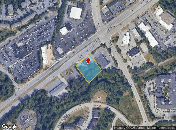
Property Record
8621 Baltimore National Pike, Ellicott City, MD 21043
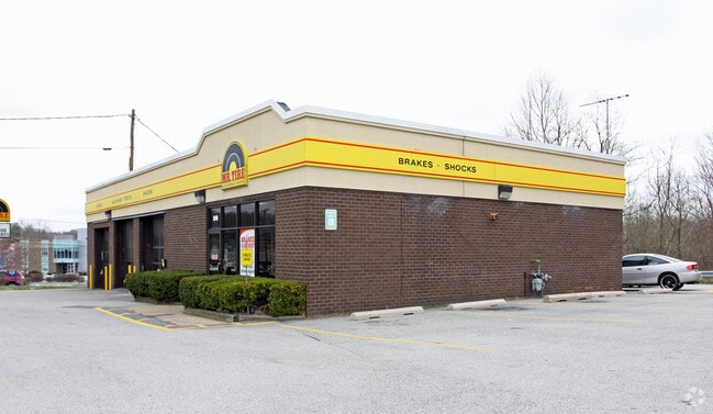
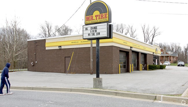
This Property Is For Sale
NEARBY LISTINGS FOR SALE OR LEASE
Property Detail
8621 Baltimore National Pike
Baltimore-Columbia-Towson, MD
Ellicott City
02-197901
LOT 2 .979 ACRE 8621 BALTIMORE NATIONAL ELLICOTT CITY
Autorepair
Howard
X
Maryland
24013C0450D
2
2024
0.98 AC
2025
Ellicott City
602900
Baltimore
3,412 SF
DEMOGRAPHICS near 8621 Baltimore National Pike
1 Mile
3 Mile
5 Mile
2024 Total Population
16,190
70,651
179,141
2029 Population
16,803
71,757
180,751
Pop Growth 2024-2029
+ 3.79%
+ 1.57%
+ 0.90%
Average Age
39
41
40
2024 Total Households
6,223
25,433
65,222
HH Growth 2024-2029
+ 4.07%
+ 1.58%
+ 0.87%
Median Household Inc
$80,253
$128,516
$112,466
Avg Household Size
2.50
2.70
2.70
2024 Avg HH Vehicles
1.00
2.00
2.00
Median Home Value
$483,058
$538,631
$481,004
Median Year Built
1993
1986
1983
Nearby Places
Map Layers
Map Styles
 Street
 Aerial
- Restaurants
- Banks
- Shops
- Fitness
- Groceries
PUBLIC TRANSPORTATION
AIRPORT
Baltimore/Washington International Thurgood Marshall
DRIVE
WALK
Distance
Baltimore/Washington International Thurgood Marshall
23 min
12.4 mi
Freight Ports
Port of Baltimore
DRIVE
WALK
Distance
Port of Baltimore
24 min
14.3 mi
Nearby Properties
Address
Land Use
TOTAL SIZE
Lot Size
Zoning
Address
Land Use
TOTAL SIZE
Lot Size
Zoning
33,342 SF
94.97 AC
RA15
Address
Land Use
TOTAL SIZE
Lot Size
Zoning
1,930 SF
49.68 AC
PSC
Address
Land Use
TOTAL SIZE
Lot Size
Zoning
48,414 SF
19.18 AC
RA15
Address
Land Use
TOTAL SIZE
Lot Size
Zoning
31,590 SF
18.89 AC
RA15
Address
Land Use
TOTAL SIZE
Lot Size
Zoning
36,399 SF
25.30 AC
RA15
Address
Land Use
TOTAL SIZE
Lot Size
Zoning
279,539 SF
46.77 AC
R20
Address
Land Use
TOTAL SIZE
Lot Size
Zoning
26.14 AC
DR16
Address
Land Use
TOTAL SIZE
Lot Size
Zoning
48,168 SF
14.91 AC
RA15
Address
Land Use
TOTAL SIZE
Lot Size
Zoning
237,128 SF
24.77 AC
B2
Address
Land Use
TOTAL SIZE
Lot Size
Zoning
204,875 SF
5.81 AC
POR
Address
Land Use
TOTAL SIZE
Lot Size
Zoning
132,865 SF
27.08 AC
SC
Address
Land Use
TOTAL SIZE
Lot Size
Zoning
166,406 SF
11.22 AC
R20
Address
Land Use
TOTAL SIZE
Lot Size
Zoning
118,460 SF
17.85 AC
O2
Address
Land Use
TOTAL SIZE
Lot Size
Zoning
58,644 SF
31.75 AC
B2
Address
Land Use
TOTAL SIZE
Lot Size
Zoning
23,962 SF
17.31 AC
BRCS2
Address
Land Use
TOTAL SIZE
Lot Size
Zoning
165,860 SF
3.35 AC
BLCCC
Address
Land Use
TOTAL SIZE
Lot Size
Zoning
15,128 SF
10.21 AC
RA15
Address
Land Use
TOTAL SIZE
Lot Size
Zoning
129,423 SF
38.77 AC
DR5.5
Address
Land Use
TOTAL SIZE
Lot Size
Zoning
2,960 SF
18.72 AC
DR3.5
Address
Land Use
TOTAL SIZE
Lot Size
Zoning
117,444 SF
19.97 AC
POR
Address
Land Use
TOTAL SIZE
Lot Size
Zoning
91,716 SF
15.07 AC
POR
Address
Land Use
TOTAL SIZE
Lot Size
Zoning
14,838 SF
14.40 AC
RA15
Address
Land Use
TOTAL SIZE
Lot Size
Zoning
11.01 AC
DR16
Address
Land Use
TOTAL SIZE
Lot Size
Zoning
117,518 SF
22.27 AC
RSC
Address
Land Use
TOTAL SIZE
Lot Size
Zoning
41,286 SF
12.62 AC
RA15
Address
Land Use
TOTAL SIZE
Lot Size
Zoning
23,932 SF
11.34 AC
RA15
Address
Land Use
TOTAL SIZE
Lot Size
Zoning
40,850 SF
8.43 AC
B2
Address
Land Use
TOTAL SIZE
Lot Size
Zoning
92,017 SF
16.22 AC
R 20
Address
Land Use
TOTAL SIZE
Lot Size
Zoning
66,350 SF
15.88 AC
R20
Address
Land Use
TOTAL SIZE
Lot Size
Zoning
8,208 SF
5.09 AC
RA15
The World's #1 Commercial Real Estate Marketplace
Connect with us
© 2025 CoStar Group
The information above has been obtained from sources believed reliable. While we do not doubt its accuracy we have not verified it and make no guarantee, warranty or representation about it. It is your responsibility to independently confirm its accuracy and completeness. Any projections, opinions, assumptions, or estimates used are for example only and do not represent the current or future performance of the property. The value of this transaction to you depends on tax and other factors which should be evaluated by your tax, financial, and legal advisors. You and your advisors should conduct a careful, independent investigation of the property to determine to your satisfaction the suitability of the property for your needs.