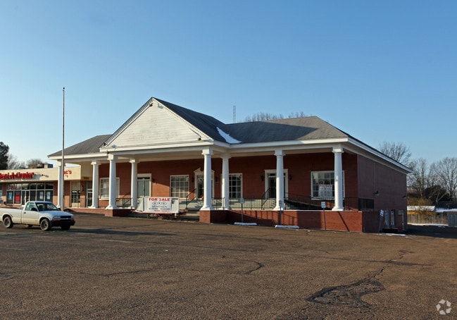
Property Record
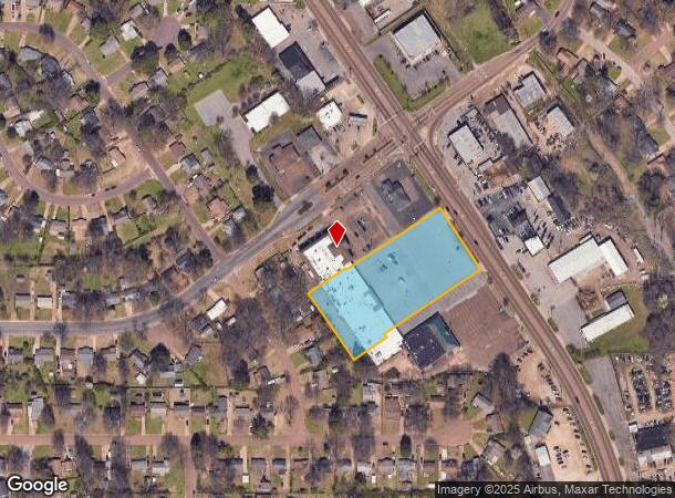
8625 Highway 51 N, Southaven, MS 38671

Current Lease Availabilities
NEARBY LISTINGS FOR SALE OR LEASE
Property Detail
8625 Highway 51 N
Memphis, TN-MS-AR
Southaven S/D
1086232200000200
SOUTHAVEN S/D COMM LOT B & C LOT 2
Realpropertynec
DeSoto
X
Mississippi
47157C0560F
2
2025
2.33 AC
2025
DeSoto County
070421
Memphis
25,770 SF
DEMOGRAPHICS near 8625 Highway 51 N
1 Mile
3 Mile
5 Mile
2024 Total Population
8,644
58,543
136,696
2029 Population
9,340
61,465
142,823
Pop Growth 2024-2029
+ 8.05%
+ 4.99%
+ 4.48%
Average Age
38
38
38
2024 Total Households
3,302
22,063
51,992
HH Growth 2024-2029
+ 8.09%
+ 5.03%
+ 4.53%
Median Household Inc
$44,292
$46,274
$46,701
Avg Household Size
2.50
2.60
2.60
2024 Avg HH Vehicles
2.00
2.00
2.00
Median Home Value
$128,070
$122,989
$135,647
Median Year Built
1972
1977
1977
Nearby Places
Map Layers
Map Styles
 Street
 Aerial
- Restaurants
- Banks
- Shops
- Fitness
- Groceries
PUBLIC TRANSPORTATION
AIRPORT
Memphis International
DRIVE
WALK
Distance
Memphis International
14 min
8.0 mi
Nearby Properties
Address
Land Use
TOTAL SIZE
Lot Size
Zoning
Address
Land Use
TOTAL SIZE
Lot Size
Zoning
1,013,319 SF
38.86 AC
EMP
Address
Land Use
TOTAL SIZE
Lot Size
Zoning
732,894 SF
79.73 AC
WD
Address
Land Use
TOTAL SIZE
Lot Size
Zoning
1,009,363 SF
78.56 AC
EMP
Address
Land Use
TOTAL SIZE
Lot Size
Zoning
853,440 SF
39.22 AC
EMP
Address
Land Use
TOTAL SIZE
Lot Size
Zoning
321.59 AC
R-8
Address
Land Use
TOTAL SIZE
Lot Size
Zoning
1,021,440 SF
57.67 AC
M-1
Address
Land Use
TOTAL SIZE
Lot Size
Zoning
432,700 SF
28.16 AC
EMP
Address
Land Use
TOTAL SIZE
Lot Size
Zoning
810,225 SF
47.71 AC
M-1
Address
Land Use
TOTAL SIZE
Lot Size
Zoning
188,404 SF
59.17 AC
R-8
Address
Land Use
TOTAL SIZE
Lot Size
Zoning
165,227 SF
25.12 AC
RU-3
Address
Land Use
TOTAL SIZE
Lot Size
Zoning
581,346 SF
39.98 AC
PUD
Address
Land Use
TOTAL SIZE
Lot Size
Zoning
61,164 SF
36.95 AC
RU-3
Address
Land Use
TOTAL SIZE
Lot Size
Zoning
230,103 SF
22.07 AC
CMU-2
Address
Land Use
TOTAL SIZE
Lot Size
Zoning
779,632 SF
46.22 AC
PBP
Address
Land Use
TOTAL SIZE
Lot Size
Zoning
222,932 SF
19.52 AC
C-1
Address
Land Use
TOTAL SIZE
Lot Size
Zoning
702,792 SF
37.11 AC
PBP
Address
Land Use
TOTAL SIZE
Lot Size
Zoning
79,658 SF
7 AC
RU-3
Address
Land Use
TOTAL SIZE
Lot Size
Zoning
79,340 SF
7 AC
RU-3
Address
Land Use
TOTAL SIZE
Lot Size
Zoning
619,021 SF
28.71 AC
PBP
Address
Land Use
TOTAL SIZE
Lot Size
Zoning
601,700 SF
29.51 AC
PBP
Address
Land Use
TOTAL SIZE
Lot Size
Zoning
408,580 SF
31.28 AC
M-1
Address
Land Use
TOTAL SIZE
Lot Size
Zoning
111,541 SF
8.88 AC
R-8
Address
Land Use
TOTAL SIZE
Lot Size
Zoning
519,647 SF
29.67 AC
PBP
Address
Land Use
TOTAL SIZE
Lot Size
Zoning
23,416 SF
5.81 AC
RU-3
Address
Land Use
TOTAL SIZE
Lot Size
Zoning
554,433 SF
24.57 AC
PBP
Address
Land Use
TOTAL SIZE
Lot Size
Zoning
18,228 SF
6.17 AC
CMU-1
Address
Land Use
TOTAL SIZE
Lot Size
Zoning
11,937 SF
18.14 AC
PUD
Address
Land Use
TOTAL SIZE
Lot Size
Zoning
454,272 SF
22.28 AC
PBP
Address
Land Use
TOTAL SIZE
Lot Size
Zoning
167,607 SF
5.52 AC
CMU-2
Address
Land Use
TOTAL SIZE
Lot Size
Zoning
48,171 SF
6.97 AC
R-10
The World's #1 Commercial Real Estate Marketplace
Connect with us
© 2026 CoStar Group
The information above has been obtained from sources believed reliable. While we do not doubt its accuracy we have not verified it and make no guarantee, warranty or representation about it. It is your responsibility to independently confirm its accuracy and completeness. Any projections, opinions, assumptions, or estimates used are for example only and do not represent the current or future performance of the property. The value of this transaction to you depends on tax and other factors which should be evaluated by your tax, financial, and legal advisors. You and your advisors should conduct a careful, independent investigation of the property to determine to your satisfaction the suitability of the property for your needs.