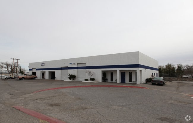
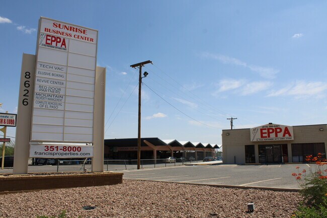
Property Record
8626 Dyer St, El Paso, TX 79904

Current Lease Availabilities
Property Detail
8626 Dyer St
El Paso, TX
BLK 1 RISING SUN LOT 1
R568-999-0010-0100
EL PASO
Commercialnec
Texas
C3
1
2024
2.86 AC
2025
Northeast
000301
El Paso
17,603 SF
NEARBY LISTINGS FOR SALE OR LEASE
-
-
View all El Paso listings for lease on LoopNet.com
DEMOGRAPHICS near 8626 Dyer St
1 mile
3 mile
5 mile
2024 Total Population
18,065
57,325
137,389
2029 Population
18,424
57,967
138,875
Pop Growth 2024-2029
+ 1.99%
+ 1.12%
+ 1.08%
Average Age
37
37
37
2024 Total Households
6,861
21,616
49,042
HH Growth 2024-2029
+ 2.17%
+ 1.29%
+ 1.13%
Median Household Inc
$30,589
$43,943
$50,896
Avg Household Size
2.60
2.60
2.70
2024 Avg HH Vehicles
1.00
2.00
2.00
Median Home Value
$118,534
$148,711
$155,888
Median Year Built
1970
1970
1973
Nearby Places
Map Layers
Map Styles
 Street
 Aerial
Transit
 Traffic
 Biking
Places
Listings with unknown addresses are not visible on the map
- Restaurants
- Banks
- Shops
- Fitness
- Groceries
PUBLIC TRANSPORTATION
AIRPORT
El Paso International
Drive
Walk
Distance
El Paso International
19 min
9.5 mi
Freight Ports
Port of Corpus Christi
Drive
Walk
Distance
Port of Corpus Christi
686 min
698.0 mi
Nearby Properties
Address
Land Use
TOTAL SIZE
Lot Size
Zoning
Address
Land Use
TOTAL SIZE
Lot Size
Zoning
261,148 SF
21.61 AC
PR2
Address
Land Use
TOTAL SIZE
Lot Size
Zoning
117,210 SF
8.55 AC
R4
Address
Land Use
TOTAL SIZE
Lot Size
Zoning
73,904 SF
42.88 AC
R4
Address
Land Use
TOTAL SIZE
Lot Size
Zoning
136,000 SF
84.83 AC
R4
Address
Land Use
TOTAL SIZE
Lot Size
Zoning
240,114 SF
26.84 AC
C1
Address
Land Use
TOTAL SIZE
Lot Size
Zoning
348,316 SF
39.67 AC
R4
Address
Land Use
TOTAL SIZE
Lot Size
Zoning
177.87 AC
Address
Land Use
TOTAL SIZE
Lot Size
Zoning
468,270 SF
60 AC
M1
Address
Land Use
TOTAL SIZE
Lot Size
Zoning
140,086 SF
13.13 AC
C3
Address
Land Use
TOTAL SIZE
Lot Size
Zoning
251,542 SF
12.76 AC
C1
Address
Land Use
TOTAL SIZE
Lot Size
Zoning
88,806 SF
9.41 AC
C1S
Address
Land Use
TOTAL SIZE
Lot Size
Zoning
112,888 SF
5.60 AC
SCZ
Address
Land Use
TOTAL SIZE
Lot Size
Zoning
164,884 SF
14.65 AC
C4
Address
Land Use
TOTAL SIZE
Lot Size
Zoning
28,289 SF
3.31 AC
C1
Address
Land Use
TOTAL SIZE
Lot Size
Zoning
136,880 SF
19.21 AC
C3
Address
Land Use
TOTAL SIZE
Lot Size
Zoning
67,808 SF
9.64 AC
C1
Address
Land Use
TOTAL SIZE
Lot Size
Zoning
44,178 SF
1.03 AC
A1C
Address
Land Use
TOTAL SIZE
Lot Size
Zoning
102,026 SF
5.90 AC
M1
Address
Land Use
TOTAL SIZE
Lot Size
Zoning
219,241 SF
6.92 AC
M1
Address
Land Use
TOTAL SIZE
Lot Size
Zoning
75,857 SF
C1
Address
Land Use
TOTAL SIZE
Lot Size
Zoning
113,724 SF
9.65 AC
C3
Address
Land Use
TOTAL SIZE
Lot Size
Zoning
68,431 SF
2.41 AC
R4
Address
Land Use
TOTAL SIZE
Lot Size
Zoning
27,963 SF
2 AC
C1
Address
Land Use
TOTAL SIZE
Lot Size
Zoning
211,730 SF
8.52 AC
C3S
Address
Land Use
TOTAL SIZE
Lot Size
Zoning
113,864 SF
11.34 AC
C4
Address
Land Use
TOTAL SIZE
Lot Size
Zoning
45,752 SF
3.05 AC
R4
Address
Land Use
TOTAL SIZE
Lot Size
Zoning
256,048 SF
36.89 AC
R4
Address
Land Use
TOTAL SIZE
Lot Size
Zoning
113,898 SF
8.88 AC
M1
Address
Land Use
TOTAL SIZE
Lot Size
Zoning
41,412 SF
6.36 AC
AM
Address
Land Use
TOTAL SIZE
Lot Size
Zoning
127,112 SF
7.24 AC
A2
The World's #1 Commercial Real Estate Marketplace
Connect with us
© 2026 CoStar Group
The information above has been obtained from sources believed reliable. While we do not doubt its accuracy we have not verified it and make no guarantee, warranty or representation about it. It is your responsibility to independently confirm its accuracy and completeness. Any projections, opinions, assumptions, or estimates used are for example only and do not represent the current or future performance of the property. The value of this transaction to you depends on tax and other factors which should be evaluated by your tax, financial, and legal advisors. You and your advisors should conduct a careful, independent investigation of the property to determine to your satisfaction the suitability of the property for your needs.