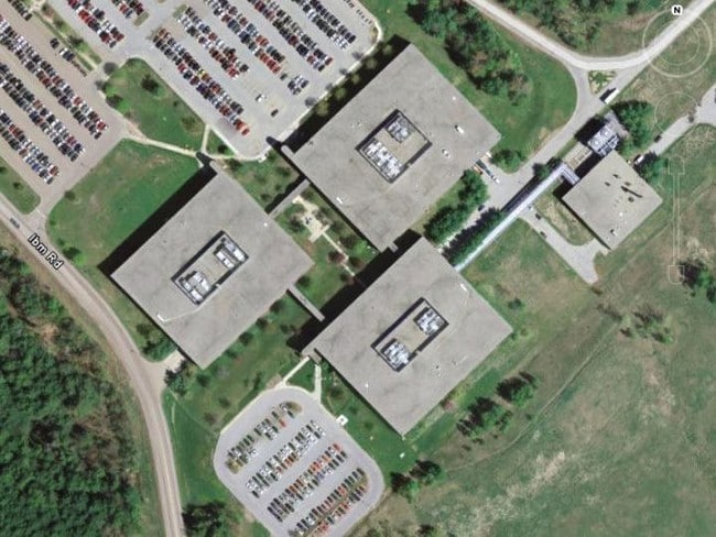
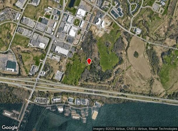
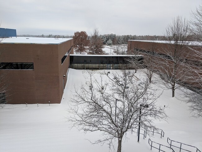
Property Record
Ibm Rd, Williston, VT 05495
NEARBY LISTINGS FOR SALE OR LEASE
Property Detail
Ibm Rd
Burlington-South Burlington, VT
IBM ROAD 326422470602
759-241-11611
Chittenden
Medicalbuilding
Vermont
2021
440.60 AC
2021
Vermont North Area
002701
Other Market Areas
17,688 SF
DEMOGRAPHICS near Ibm Rd
1 mile
3 mile
5 mile
2024 Total Population
772
25,293
54,785
2029 Population
783
25,647
55,458
Pop Growth 2024-2029
+ 1.42%
+ 1.40%
+ 1.23%
Average Age
44
42
40
2024 Total Households
312
10,852
23,490
HH Growth 2024-2029
+ 1.28%
+ 1.55%
+ 1.32%
Median Household Inc
$111,250
$94,493
$87,047
Avg Household Size
2.40
2.30
2.20
2024 Avg HH Vehicles
2.00
2.00
2.00
Median Home Value
$402,532
$369,092
$362,388
Median Year Built
1985
1985
1985
Nearby Places
Map Layers
Map Styles
 Street
 Aerial
Transit
 Traffic
 Biking
Places
Listings with unknown addresses are not visible on the map
- Restaurants
- Banks
- Shops
- Fitness
- Groceries
PUBLIC TRANSPORTATION
COMMUTER RAIL
Essex Junction-Burlington Amtrak Station (Vermonter - Amtrak)
Drive
Walk
Distance
Essex Junction-Burlington Amtrak Station (Vermonter - Amtrak)
7 min
3.7 mi
Btn (Ethan Allen Express - Amtrak)
Drive
Walk
Distance
Btn (Ethan Allen Express - Amtrak)
13 min
7.5 mi
AIRPORT
Patrick Leahy Burlington International
Drive
Walk
Distance
Patrick Leahy Burlington International
16 min
4.9 mi
Plattsburgh International
Drive
Walk
Distance
Plattsburgh International
72 min
38.9 mi
Freight Ports
Montreal
Drive
Walk
Distance
Montreal
131 min
102.2 mi
SALE & LEASE HISTORY
LISTING DATE
SALE/LEASE

Mar 02, 2020
For Lease
Nearby Properties
Address
Land Use
TOTAL SIZE
Lot Size
Zoning
Address
Land Use
TOTAL SIZE
Lot Size
Zoning
227.57 AC
Address
Land Use
TOTAL SIZE
Lot Size
Zoning
Address
Land Use
TOTAL SIZE
Lot Size
Zoning
Address
Land Use
TOTAL SIZE
Lot Size
Zoning
Address
Land Use
TOTAL SIZE
Lot Size
Zoning
52,824 SF
14.43 AC
Address
Land Use
TOTAL SIZE
Lot Size
Zoning
54,000 SF
3.98 AC
Address
Land Use
TOTAL SIZE
Lot Size
Zoning
Address
Land Use
TOTAL SIZE
Lot Size
Zoning
54,000 SF
5 AC
Address
Land Use
TOTAL SIZE
Lot Size
Zoning
Address
Land Use
TOTAL SIZE
Lot Size
Zoning
69,120 SF
11.20 AC
Address
Land Use
TOTAL SIZE
Lot Size
Zoning
35,064 SF
3.71 AC
Address
Land Use
TOTAL SIZE
Lot Size
Zoning
78.78 AC
Address
Land Use
TOTAL SIZE
Lot Size
Zoning
Address
Land Use
TOTAL SIZE
Lot Size
Zoning
Address
Land Use
TOTAL SIZE
Lot Size
Zoning
30,000 SF
4.52 AC
Address
Land Use
TOTAL SIZE
Lot Size
Zoning
30,600 SF
2.94 AC
Address
Land Use
TOTAL SIZE
Lot Size
Zoning
Address
Land Use
TOTAL SIZE
Lot Size
Zoning
54,446 SF
6.43 AC
Address
Land Use
TOTAL SIZE
Lot Size
Zoning
29,150 SF
3.90 AC
Address
Land Use
TOTAL SIZE
Lot Size
Zoning
Address
Land Use
TOTAL SIZE
Lot Size
Zoning
Address
Land Use
TOTAL SIZE
Lot Size
Zoning
Address
Land Use
TOTAL SIZE
Lot Size
Zoning
Address
Land Use
TOTAL SIZE
Lot Size
Zoning
Address
Land Use
TOTAL SIZE
Lot Size
Zoning
28,000 SF
3.36 AC
Address
Land Use
TOTAL SIZE
Lot Size
Zoning
18,643 SF
5.58 AC
Address
Land Use
TOTAL SIZE
Lot Size
Zoning
55,312 SF
25 AC
Address
Land Use
TOTAL SIZE
Lot Size
Zoning
40,319 SF
3.64 AC
Address
Land Use
TOTAL SIZE
Lot Size
Zoning
19,440 SF
3.50 AC
Address
Land Use
TOTAL SIZE
Lot Size
Zoning
30,000 SF
7.86 AC
The World's #1 Commercial Real Estate Marketplace
Connect with us
© 2026 CoStar Group
The information above has been obtained from sources believed reliable. While we do not doubt its accuracy we have not verified it and make no guarantee, warranty or representation about it. It is your responsibility to independently confirm its accuracy and completeness. Any projections, opinions, assumptions, or estimates used are for example only and do not represent the current or future performance of the property. The value of this transaction to you depends on tax and other factors which should be evaluated by your tax, financial, and legal advisors. You and your advisors should conduct a careful, independent investigation of the property to determine to your satisfaction the suitability of the property for your needs.