Property Record
8620 Research Dr, Charlotte, NC 28262

NEARBY LISTINGS FOR SALE OR LEASE
Property Detail
8620 Research Dr
Charlotte-Concord-Gastonia, NC-SC
University Research Park Map 100
047-141-18
L1 M31-881
Commercialnec
Mecklenburg
X
North Carolina
3710457700K
1
2024
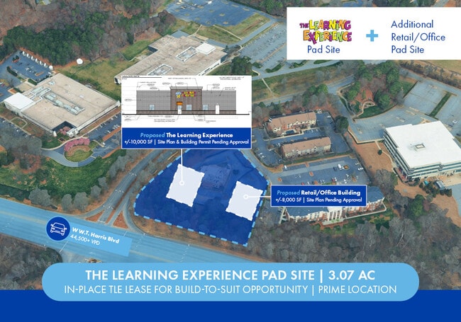
3.07 AC
2025
Northeast
005533
Charlotte
6,865 SF
DEMOGRAPHICS near 8620 Research Dr
1 Mile
3 Mile
5 Mile
2024 Total Population
5,549
90,297
203,199
2029 Population
5,956
96,086
216,154
Pop Growth 2024-2029
+ 7.33%
+ 6.41%
+ 6.38%
Average Age
32
34
35
2024 Total Households
2,655
36,612
78,451
HH Growth 2024-2029
+ 7.72%
+ 6.45%
+ 6.41%
Median Household Inc
$63,911
$57,273
$60,890
Avg Household Size
2.00
2.40
2.50
2024 Avg HH Vehicles
1.00
2.00
2.00
Median Home Value
$224,637
$239,168
$251,319
Median Year Built
2003
1998
1998
Nearby Places
Map Layers
Map Styles
 Street
 Aerial
- Restaurants
- Banks
- Shops
- Fitness
- Groceries
PUBLIC TRANSPORTATION
COMMUTER RAIL
DRIVE
WALK
Distance
13 min
7.5 mi
AIRPORT
Concord-Padgett Regional
DRIVE
WALK
Distance
Concord-Padgett Regional
14 min
7.7 mi
Charlotte/Douglas International
DRIVE
WALK
Distance
Charlotte/Douglas International
28 min
16.9 mi
SALE & LEASE HISTORY
LISTING DATE
SALE/LEASE

Sep 29, 2025
For Sale
Dec 05, 2023
For Lease
Dec 05, 2023
For Sale
Nearby Properties
Address
Land Use
TOTAL SIZE
Lot Size
Zoning
Address
Land Use
TOTAL SIZE
Lot Size
Zoning
2,022,784 SF
654.80 AC
INST
Address
Land Use
TOTAL SIZE
Lot Size
Zoning
2,534,387 SF
135.23 AC
RE2
Address
Land Use
TOTAL SIZE
Lot Size
Zoning
2,215,042 SF
68.45 AC
RE2
Address
Land Use
TOTAL SIZE
Lot Size
Zoning
1,474,585 SF
30.93 AC
Address
Land Use
TOTAL SIZE
Lot Size
Zoning
1,532,477 SF
92.30 AC
RE1
Address
Land Use
TOTAL SIZE
Lot Size
Zoning
628,300 SF
197.32 AC
INST
Address
Land Use
TOTAL SIZE
Lot Size
Zoning
497,730 SF
32.66 AC
B2CD
Address
Land Use
TOTAL SIZE
Lot Size
Zoning
727,169 SF
6.07 AC
INST
Address
Land Use
TOTAL SIZE
Lot Size
Zoning
389,720 SF
33.83 AC
R12MFCD
Address
Land Use
TOTAL SIZE
Lot Size
Zoning
471,271 SF
24.30 AC
MUDD-O
Address
Land Use
TOTAL SIZE
Lot Size
Zoning
419,364 SF
17.40 AC
Address
Land Use
TOTAL SIZE
Lot Size
Zoning
315,076 SF
21.16 AC
RE1
Address
Land Use
TOTAL SIZE
Lot Size
Zoning
481,045 SF
36.15 AC
R12MFCD
Address
Land Use
TOTAL SIZE
Lot Size
Zoning
412,078 SF
27.46 AC
R17MFCD
Address
Land Use
TOTAL SIZE
Lot Size
Zoning
333,683 SF
24.11 AC
RE2
Address
Land Use
TOTAL SIZE
Lot Size
Zoning
16,601 SF
7.42 AC
R-12MF(CD)
Address
Land Use
TOTAL SIZE
Lot Size
Zoning
401,069 SF
31.52 AC
R12MFCD
Address
Land Use
TOTAL SIZE
Lot Size
Zoning
346,666 SF
26.53 AC
R17MFCD
Address
Land Use
TOTAL SIZE
Lot Size
Zoning
164,809 SF
94.60 AC
Address
Land Use
TOTAL SIZE
Lot Size
Zoning
389,680 SF
28.83 AC
R17MFCD
Address
Land Use
TOTAL SIZE
Lot Size
Zoning
324,898 SF
22.31 AC
R17MFCD
Address
Land Use
TOTAL SIZE
Lot Size
Zoning
347,856 SF
21.16 AC
R17MFCD
Address
Land Use
TOTAL SIZE
Lot Size
Zoning
215,899 SF
4.86 AC
B-2(CD)
Address
Land Use
TOTAL SIZE
Lot Size
Zoning
284,360 SF
21.68 AC
R12MFCD
Address
Land Use
TOTAL SIZE
Lot Size
Zoning
335,688 SF
22.54 AC
Address
Land Use
TOTAL SIZE
Lot Size
Zoning
549,120 SF
5.29 AC
NS
Address
Land Use
TOTAL SIZE
Lot Size
Zoning
358,524 SF
23.80 AC
R17MFCD
Address
Land Use
TOTAL SIZE
Lot Size
Zoning
497,811 SF
49.75 AC
RE2
Address
Land Use
TOTAL SIZE
Lot Size
Zoning
306,269 SF
9.44 AC
MUDD-O
Address
Land Use
TOTAL SIZE
Lot Size
Zoning
464,520 SF
3.43 AC
The World's #1 Commercial Real Estate Marketplace
Connect with us
© 2025 CoStar Group
The information above has been obtained from sources believed reliable. While we do not doubt its accuracy we have not verified it and make no guarantee, warranty or representation about it. It is your responsibility to independently confirm its accuracy and completeness. Any projections, opinions, assumptions, or estimates used are for example only and do not represent the current or future performance of the property. The value of this transaction to you depends on tax and other factors which should be evaluated by your tax, financial, and legal advisors. You and your advisors should conduct a careful, independent investigation of the property to determine to your satisfaction the suitability of the property for your needs.