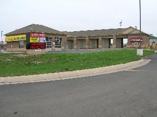
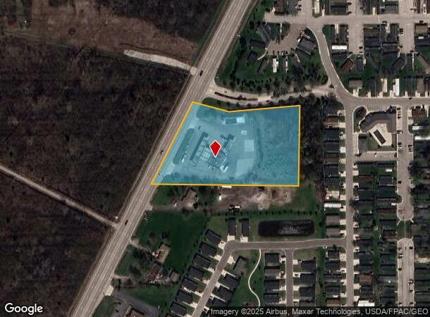
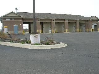
Property Record
8638 N Telegraph Rd, Newport, MI 48166
Current Lease Availabilities
NEARBY LISTINGS FOR SALE OR LEASE
-
-
View all Newport listings for lease on LoopNet.com
Property Detail
8638 N Telegraph Rd
07-003-020-00
9E 6S 3
Supermarket
Monroe
X
Michigan
26115C0113E
3.92 AC
2025
Monroe County
2025
Detroit
831201
Monroe, MI
3,136 SF
DEMOGRAPHICS near 8638 N Telegraph Rd
1 Mile
3 Mile
5 Mile
2024 Total Population
3,487
11,828
28,548
2029 Population
3,527
12,070
29,147
Pop Growth 2024-2029
+ 1.15%
+ 2.05%
+ 2.10%
Average Age
35
38
41
2024 Total Households
1,307
4,462
11,189
HH Growth 2024-2029
+ 1.22%
+ 2.04%
+ 2.08%
Median Household Inc
$57,894
$64,073
$67,419
Avg Household Size
2.60
2.60
2.50
2024 Avg HH Vehicles
2.00
2.00
2.00
Median Home Value
$60,441
$177,603
$211,658
Median Year Built
1999
1996
1988
Nearby Places
Map Layers
Map Styles
 Street
 Aerial
- Restaurants
- Banks
- Shops
- Fitness
- Groceries
PUBLIC TRANSPORTATION
AIRPORT
Detroit Metro Wayne County
DRIVE
WALK
Distance
Detroit Metro Wayne County
21 min
17.0 mi
Windsor International
DRIVE
WALK
Distance
Windsor International
59 min
40.6 mi
Freight Ports
Port of Toledo
DRIVE
WALK
Distance
Port of Toledo
44 min
31.3 mi
Nearby Properties
Address
Land Use
TOTAL SIZE
Lot Size
Zoning
Address
Land Use
TOTAL SIZE
Lot Size
Zoning
Address
Land Use
TOTAL SIZE
Lot Size
Zoning
453,206 SF
156.60 AC
AG
Address
Land Use
TOTAL SIZE
Lot Size
Zoning
Address
Land Use
TOTAL SIZE
Lot Size
Zoning
720,420 SF
71.34 AC
LM-LIGHT M
Address
Land Use
TOTAL SIZE
Lot Size
Zoning
5,216 SF
81.10 AC
MHP
Address
Land Use
TOTAL SIZE
Lot Size
Zoning
290,248 SF
52.03 AC
Address
Land Use
TOTAL SIZE
Lot Size
Zoning
29.81 AC
MHP
Address
Land Use
TOTAL SIZE
Lot Size
Zoning
41,920 SF
48.72 AC
Address
Land Use
TOTAL SIZE
Lot Size
Zoning
2,100 SF
36.48 AC
MHP
Address
Land Use
TOTAL SIZE
Lot Size
Zoning
19,364 SF
30.80 AC
Address
Land Use
TOTAL SIZE
Lot Size
Zoning
100,407 SF
16.34 AC
Address
Land Use
TOTAL SIZE
Lot Size
Zoning
40,857 SF
17.30 AC
Address
Land Use
TOTAL SIZE
Lot Size
Zoning
4,419 SF
64.34 AC
MHP
Address
Land Use
TOTAL SIZE
Lot Size
Zoning
28.87 AC
MHP
Address
Land Use
TOTAL SIZE
Lot Size
Zoning
100,918 SF
14.41 AC
Address
Land Use
TOTAL SIZE
Lot Size
Zoning
3,272 SF
121.75 AC
MHP
Address
Land Use
TOTAL SIZE
Lot Size
Zoning
26.52 AC
MHP
Address
Land Use
TOTAL SIZE
Lot Size
Zoning
1,584 SF
23.04 AC
MHP
Address
Land Use
TOTAL SIZE
Lot Size
Zoning
2,472 SF
46.65 AC
Address
Land Use
TOTAL SIZE
Lot Size
Zoning
21,528 SF
12.61 AC
Address
Land Use
TOTAL SIZE
Lot Size
Zoning
37,665 SF
9.13 AC
Address
Land Use
TOTAL SIZE
Lot Size
Zoning
36,604 SF
3.96 AC
Address
Land Use
TOTAL SIZE
Lot Size
Zoning
7,514 SF
43.17 AC
Address
Land Use
TOTAL SIZE
Lot Size
Zoning
5,712 SF
0.84 AC
Address
Land Use
TOTAL SIZE
Lot Size
Zoning
37,447 SF
4.71 AC
Address
Land Use
TOTAL SIZE
Lot Size
Zoning
10,717 SF
8.60 AC
Address
Land Use
TOTAL SIZE
Lot Size
Zoning
34.40 AC
MHP
Address
Land Use
TOTAL SIZE
Lot Size
Zoning
14,118 SF
37.23 AC
Address
Land Use
TOTAL SIZE
Lot Size
Zoning
16,239 SF
2.71 AC
The World's #1 Commercial Real Estate Marketplace
Connect with us
© 2025 CoStar Group
The information above has been obtained from sources believed reliable. While we do not doubt its accuracy we have not verified it and make no guarantee, warranty or representation about it. It is your responsibility to independently confirm its accuracy and completeness. Any projections, opinions, assumptions, or estimates used are for example only and do not represent the current or future performance of the property. The value of this transaction to you depends on tax and other factors which should be evaluated by your tax, financial, and legal advisors. You and your advisors should conduct a careful, independent investigation of the property to determine to your satisfaction the suitability of the property for your needs.