Property Record
8645 Dimond D Cir, Anchorage, AK 99515
NEARBY LISTINGS FOR SALE OR LEASE
-
-
-
-
No Photo
-
-
View all Anchorage listings for sale on LoopNet.com
Property Detail
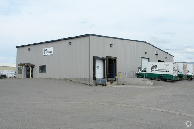
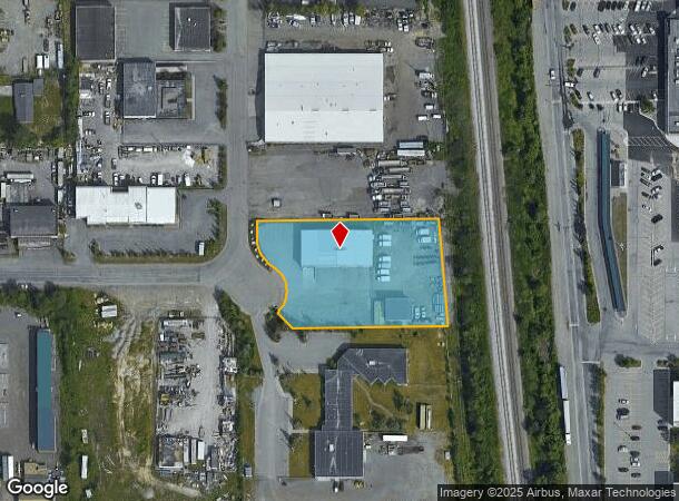
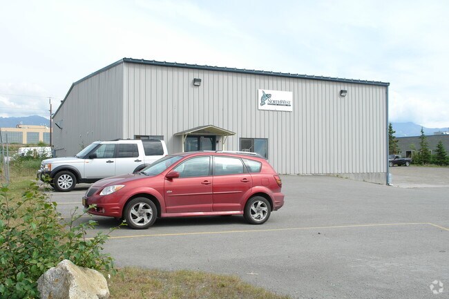
8645 Dimond D Cir
Anchorage, AK
Dimond D Development
01309135000
DIMOND D DEVELOPMENT BLK 2 LT 6
Warehouse
Anchorage
X
Alaska
0200050763D
6
2024
1.21 AC
2025
Dimond South-20
002712
Anchorage
7,200 SF
DEMOGRAPHICS near 8645 Dimond D Cir
1 Mile
3 Mile
5 Mile
2024 Total Population
9,535
89,149
170,024
2029 Population
9,391
87,484
167,300
Pop Growth 2024-2029
(1.51%)
(1.87%)
(1.60%)
Average Age
36
37
38
2024 Total Households
3,625
33,675
66,413
HH Growth 2024-2029
(1.82%)
(1.93%)
(1.63%)
Median Household Inc
$72,627
$93,650
$91,739
Avg Household Size
2.50
2.60
2.40
2024 Avg HH Vehicles
2.00
2.00
2.00
Median Home Value
$228,765
$338,185
$355,182
Median Year Built
1984
1984
1980
Nearby Places
Map Layers
Map Styles
 Street
 Aerial
- Restaurants
- Banks
- Shops
- Fitness
- Groceries
PUBLIC TRANSPORTATION
AIRPORT
Ted Stevens Anchorage International
DRIVE
WALK
Distance
Ted Stevens Anchorage International
13 min
6.3 mi
Merrill Field
DRIVE
WALK
Distance
Merrill Field
15 min
7.4 mi
Freight Ports
Port of Anchorage
DRIVE
WALK
Distance
Port of Anchorage
17 min
7.4 mi
Nearby Properties
Address
Land Use
TOTAL SIZE
Lot Size
Zoning
Address
Land Use
TOTAL SIZE
Lot Size
Zoning
381,477 SF
33.30 AC
B3
Address
Land Use
TOTAL SIZE
Lot Size
Zoning
267,442 SF
61.04 AC
PLI
Address
Land Use
TOTAL SIZE
Lot Size
Zoning
56,747 SF
6.89 AC
B3SL
Address
Land Use
TOTAL SIZE
Lot Size
Zoning
66,354 SF
44.23 AC
I2
Address
Land Use
TOTAL SIZE
Lot Size
Zoning
242,189 SF
21.83 AC
I2
Address
Land Use
TOTAL SIZE
Lot Size
Zoning
168,640 SF
3.38 AC
I2
Address
Land Use
TOTAL SIZE
Lot Size
Zoning
69 AC
PR
Address
Land Use
TOTAL SIZE
Lot Size
Zoning
217,754 SF
14.42 AC
I1
Address
Land Use
TOTAL SIZE
Lot Size
Zoning
150,075 SF
29.17 AC
PLI
Address
Land Use
TOTAL SIZE
Lot Size
Zoning
164,774 SF
29.26 AC
PLI
Address
Land Use
TOTAL SIZE
Lot Size
Zoning
31,780 SF
16.44 AC
R3
Address
Land Use
TOTAL SIZE
Lot Size
Zoning
116,420 SF
14.86 AC
B3
Address
Land Use
TOTAL SIZE
Lot Size
Zoning
154,455 SF
16.38 AC
I1
Address
Land Use
TOTAL SIZE
Lot Size
Zoning
36,178 SF
2.19 AC
I1
Address
Land Use
TOTAL SIZE
Lot Size
Zoning
59,908 SF
5.54 AC
I1
Address
Land Use
TOTAL SIZE
Lot Size
Zoning
13,657 SF
12.35 AC
R3
Address
Land Use
TOTAL SIZE
Lot Size
Zoning
79,808 SF
19.54 AC
I2
Address
Land Use
TOTAL SIZE
Lot Size
Zoning
32,247 SF
2.21 AC
B3
Address
Land Use
TOTAL SIZE
Lot Size
Zoning
170,381 SF
10.70 AC
I2
Address
Land Use
TOTAL SIZE
Lot Size
Zoning
151,322 SF
9.18 AC
I1
Address
Land Use
TOTAL SIZE
Lot Size
Zoning
178,437 SF
16.02 AC
B3SL
Address
Land Use
TOTAL SIZE
Lot Size
Zoning
48,770 SF
2.90 AC
I1
Address
Land Use
TOTAL SIZE
Lot Size
Zoning
149,219 SF
14.56 AC
B3
Address
Land Use
TOTAL SIZE
Lot Size
Zoning
65,752 SF
1.82 AC
I1
Address
Land Use
TOTAL SIZE
Lot Size
Zoning
136,593 SF
9.15 AC
I2
Address
Land Use
TOTAL SIZE
Lot Size
Zoning
52,890 SF
10.64 AC
PLI
Address
Land Use
TOTAL SIZE
Lot Size
Zoning
63,305 SF
12.11 AC
I1
Address
Land Use
TOTAL SIZE
Lot Size
Zoning
79,776 SF
27 AC
I1
Address
Land Use
TOTAL SIZE
Lot Size
Zoning
49,032 SF
3.07 AC
B3
Address
Land Use
TOTAL SIZE
Lot Size
Zoning
109,447 SF
4.54 AC
B3SL
The World's #1 Commercial Real Estate Marketplace
Connect with us
© 2025 CoStar Group
The information above has been obtained from sources believed reliable. While we do not doubt its accuracy we have not verified it and make no guarantee, warranty or representation about it. It is your responsibility to independently confirm its accuracy and completeness. Any projections, opinions, assumptions, or estimates used are for example only and do not represent the current or future performance of the property. The value of this transaction to you depends on tax and other factors which should be evaluated by your tax, financial, and legal advisors. You and your advisors should conduct a careful, independent investigation of the property to determine to your satisfaction the suitability of the property for your needs.