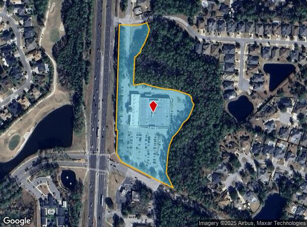
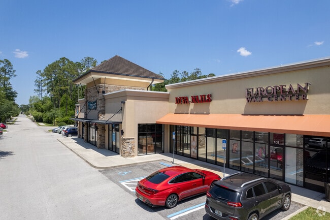
Property Record
865 Hibernia Rd, Fleming Island, FL 32003

NEARBY LISTINGS FOR SALE OR LEASE
Property Detail
865 Hibernia Rd
16-05-26-014176-000-02
(CONSV ESMT RELEASE OR 2938 PG 1671) PT S16T5R26 AS REC OR 2835 PG 793
Regionalshoppingcenterormallwithanchorstore
Clay
X
Florida
12109C0150K
6.72 AC
2024
Orange Park/Clay County
2025
Jacksonville (Florida)
030701
Jacksonville, FL
58,376 SF
DEMOGRAPHICS near 865 Hibernia Rd
1 Mile
3 Mile
5 Mile
2024 Total Population
7,010
23,091
57,826
2029 Population
7,606
25,234
64,697
Pop Growth 2024-2029
+ 8.50%
+ 9.28%
+ 11.88%
Average Age
43
42
42
2024 Total Households
2,583
8,628
20,988
HH Growth 2024-2029
+ 8.71%
+ 9.33%
+ 11.71%
Median Household Inc
$105,908
$96,937
$98,111
Avg Household Size
2.60
2.60
2.70
2024 Avg HH Vehicles
2.00
2.00
2.00
Median Home Value
$346,833
$360,831
$348,602
Median Year Built
2002
2001
2000
Nearby Places
Map Layers
Map Styles
 Street
 Aerial
- Restaurants
- Banks
- Shops
- Fitness
- Groceries
PUBLIC TRANSPORTATION
AIRPORT
Jacksonville International
DRIVE
WALK
Distance
Jacksonville International
53 min
36.9 mi
Freight Ports
Jacksonville Port
DRIVE
WALK
Distance
Jacksonville Port
43 min
25.4 mi
SALE & LEASE HISTORY
LISTING DATE
SALE/LEASE

Sep 24, 2016
For Lease
Sep 01, 2017
For Lease
Nearby Properties
Address
Land Use
TOTAL SIZE
Lot Size
Zoning
Address
Land Use
TOTAL SIZE
Lot Size
Zoning
335,398 SF
31.66 AC
Address
Land Use
TOTAL SIZE
Lot Size
Zoning
539,095 SF
68.12 AC
Address
Land Use
TOTAL SIZE
Lot Size
Zoning
171,183 SF
11.37 AC
Address
Land Use
TOTAL SIZE
Lot Size
Zoning
125,572 SF
7.20 AC
Address
Land Use
TOTAL SIZE
Lot Size
Zoning
93,294 SF
30 AC
Address
Land Use
TOTAL SIZE
Lot Size
Zoning
89,070 SF
12.33 AC
PUD
Address
Land Use
TOTAL SIZE
Lot Size
Zoning
73,282 SF
12.51 AC
PUD
Address
Land Use
TOTAL SIZE
Lot Size
Zoning
89,674 SF
25 AC
RB
Address
Land Use
TOTAL SIZE
Lot Size
Zoning
203,600 SF
29.22 AC
PUD
Address
Land Use
TOTAL SIZE
Lot Size
Zoning
80,352 SF
0.97 AC
Address
Land Use
TOTAL SIZE
Lot Size
Zoning
80,613 SF
15.21 AC
PUD
Address
Land Use
TOTAL SIZE
Lot Size
Zoning
80,690 SF
9.18 AC
PUD
Address
Land Use
TOTAL SIZE
Lot Size
Zoning
41,188 SF
5.45 AC
Address
Land Use
TOTAL SIZE
Lot Size
Zoning
90,705 SF
3.74 AC
PCD
Address
Land Use
TOTAL SIZE
Lot Size
Zoning
Address
Land Use
TOTAL SIZE
Lot Size
Zoning
42,718 SF
3.56 AC
Address
Land Use
TOTAL SIZE
Lot Size
Zoning
65,959 SF
7.02 AC
PUD
Address
Land Use
TOTAL SIZE
Lot Size
Zoning
Address
Land Use
TOTAL SIZE
Lot Size
Zoning
80,251 SF
3.51 AC
Address
Land Use
TOTAL SIZE
Lot Size
Zoning
66,340 SF
10.10 AC
PS-1
Address
Land Use
TOTAL SIZE
Lot Size
Zoning
117,968 SF
14.42 AC
PUD
Address
Land Use
TOTAL SIZE
Lot Size
Zoning
86,423 SF
18.20 AC
Address
Land Use
TOTAL SIZE
Lot Size
Zoning
54,124 SF
4.83 AC
PUD
Address
Land Use
TOTAL SIZE
Lot Size
Zoning
130,542 SF
16.18 AC
PUD
Address
Land Use
TOTAL SIZE
Lot Size
Zoning
68,727 SF
9.68 AC
Address
Land Use
TOTAL SIZE
Lot Size
Zoning
73,652 SF
11.75 AC
PUD
Address
Land Use
TOTAL SIZE
Lot Size
Zoning
50,796 SF
5.57 AC
Address
Land Use
TOTAL SIZE
Lot Size
Zoning
46,984 SF
1.85 AC
Address
Land Use
TOTAL SIZE
Lot Size
Zoning
52,764 SF
5.06 AC
The World's #1 Commercial Real Estate Marketplace
Connect with us
© 2026 CoStar Group
The information above has been obtained from sources believed reliable. While we do not doubt its accuracy we have not verified it and make no guarantee, warranty or representation about it. It is your responsibility to independently confirm its accuracy and completeness. Any projections, opinions, assumptions, or estimates used are for example only and do not represent the current or future performance of the property. The value of this transaction to you depends on tax and other factors which should be evaluated by your tax, financial, and legal advisors. You and your advisors should conduct a careful, independent investigation of the property to determine to your satisfaction the suitability of the property for your needs.