Property Record
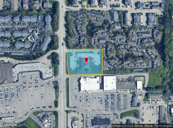
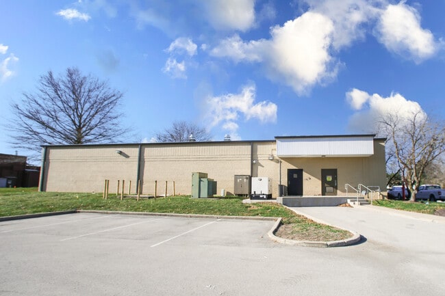
8651 Township Line Rd, Indianapolis, IN 46260
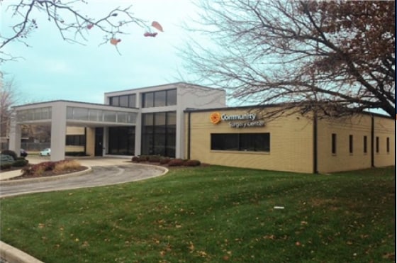
This Property Is For Sale
NEARBY LISTINGS FOR SALE OR LEASE
Property Detail
8651 Township Line Rd
49-03-16-107-011.000-800
PT SW1/4 SW1/4 S16 T17 R3 BEG 683 N OF SW COR;N268.7 E421.53 S268.7 W355.36 NW85.25 S83.82W50 TO BEG 2.585AC
Medicalbuilding
Marion
X
Indiana
18097C0037F
2.59 AC
2023
College Park
2024
Indianapolis
320105
Indianapolis-Carmel-Anderson, IN
12,088 SF
DEMOGRAPHICS near 8651 Township Line Rd
1 Mile
3 Mile
5 Mile
2024 Total Population
12,959
58,889
154,420
2029 Population
12,698
59,102
158,628
Pop Growth 2024-2029
(2.01%)
+ 0.36%
+ 2.73%
Average Age
41
39
40
2024 Total Households
6,735
25,247
65,825
HH Growth 2024-2029
(2.14%)
(0.12%)
+ 2.39%
Median Household Inc
$62,417
$71,777
$81,887
Avg Household Size
1.80
2.30
2.30
2024 Avg HH Vehicles
1.00
2.00
2.00
Median Home Value
$194,328
$263,368
$299,449
Median Year Built
1982
1982
1983
Nearby Places
- Restaurants
- Banks
- Shops
- Fitness
- Groceries
PUBLIC TRANSPORTATION
AIRPORT
Indianapolis International
DRIVE
WALK
Distance
Indianapolis International
42 min
23.4 mi
Nearby Properties
Address
Land Use
TOTAL SIZE
Lot Size
Zoning
Address
Land Use
TOTAL SIZE
Lot Size
Zoning
303,520 SF
39.62 AC
ZO01
Address
Land Use
TOTAL SIZE
Lot Size
Zoning
162,462 SF
2 AC
Address
Land Use
TOTAL SIZE
Lot Size
Zoning
2,544 SF
37.75 AC
ZO01
Address
Land Use
TOTAL SIZE
Lot Size
Zoning
285,284 SF
7.78 AC
Address
Land Use
TOTAL SIZE
Lot Size
Zoning
4,267 SF
21.06 AC
ZO01
Address
Land Use
TOTAL SIZE
Lot Size
Zoning
168,710 SF
5.24 AC
ZO01
Address
Land Use
TOTAL SIZE
Lot Size
Zoning
1,904 SF
45.69 AC
ZO01
Address
Land Use
TOTAL SIZE
Lot Size
Zoning
9,076 SF
18 AC
ZO01
Address
Land Use
TOTAL SIZE
Lot Size
Zoning
320,595 SF
10.93 AC
Address
Land Use
TOTAL SIZE
Lot Size
Zoning
301,907 SF
43.90 AC
ZO01
Address
Land Use
TOTAL SIZE
Lot Size
Zoning
521,092 SF
23.46 AC
ZO01
Address
Land Use
TOTAL SIZE
Lot Size
Zoning
89,245 SF
45.14 AC
ZO01
Address
Land Use
TOTAL SIZE
Lot Size
Zoning
359,121 SF
0.06 AC
ZO01
Address
Land Use
TOTAL SIZE
Lot Size
Zoning
195,457 SF
6.05 AC
Address
Land Use
TOTAL SIZE
Lot Size
Zoning
512,730 SF
21.80 AC
ZO01
Address
Land Use
TOTAL SIZE
Lot Size
Zoning
12,023 SF
48.47 AC
ZO01
Address
Land Use
TOTAL SIZE
Lot Size
Zoning
187,555 SF
1.85 AC
Address
Land Use
TOTAL SIZE
Lot Size
Zoning
18,768 SF
45.36 AC
ZO01
Address
Land Use
TOTAL SIZE
Lot Size
Zoning
2,103 SF
11.67 AC
ZO01
Address
Land Use
TOTAL SIZE
Lot Size
Zoning
166,503 SF
7.81 AC
Address
Land Use
TOTAL SIZE
Lot Size
Zoning
110,373 SF
47.98 AC
ZO01
Address
Land Use
TOTAL SIZE
Lot Size
Zoning
3,829 SF
24.98 AC
ZO01
Address
Land Use
TOTAL SIZE
Lot Size
Zoning
6,306 SF
33.65 AC
ZO01
Address
Land Use
TOTAL SIZE
Lot Size
Zoning
179,586 SF
10.23 AC
ZO01
Address
Land Use
TOTAL SIZE
Lot Size
Zoning
6,266 SF
19.01 AC
ZO01
Address
Land Use
TOTAL SIZE
Lot Size
Zoning
89,704 SF
28.63 AC
ZO01
Address
Land Use
TOTAL SIZE
Lot Size
Zoning
4,463 SF
29.49 AC
ZO01
Address
Land Use
TOTAL SIZE
Lot Size
Zoning
130,270 SF
7.29 AC
Address
Land Use
TOTAL SIZE
Lot Size
Zoning
14,854 SF
14.07 AC
ZO01
Address
Land Use
TOTAL SIZE
Lot Size
Zoning
155,919 SF
28.92 AC
The World's #1 Commercial Real Estate Marketplace
Connect with us
© 2025 CoStar Group
The information above has been obtained from sources believed reliable. While we do not doubt its accuracy we have not verified it and make no guarantee, warranty or representation about it. It is your responsibility to independently confirm its accuracy and completeness. Any projections, opinions, assumptions, or estimates used are for example only and do not represent the current or future performance of the property. The value of this transaction to you depends on tax and other factors which should be evaluated by your tax, financial, and legal advisors. You and your advisors should conduct a careful, independent investigation of the property to determine to your satisfaction the suitability of the property for your needs.