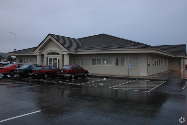
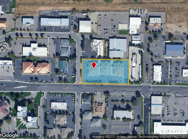
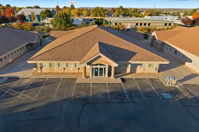
Property Record
8656 W Gage Blvd, Kennewick, WA 99336
Current Lease Availabilities
NEARBY LISTINGS FOR SALE OR LEASE
Property Detail
8656 W Gage Blvd
Kennewick-Richland, WA
THE EAST 206 FEET OF THE SOUTH 261 FEET OF THE SOUTHWEST QUARTER OF THE SOUTHWEST QUARTER OF SECTION 30, TOWNSHIP 9 NORTH, RANGE 29 EAST, W.M., BENTON COUNTY, WASHINGTON, EXCEPT THE SOUTH 50 FEET THEREOF FOR GAGE BOULEVARD. TOGETHER WITH THE WEST 206
130993000004006
Benton
Commercialnec
Washington
2024
2 AC
2024
Yakima/Kennewick
010809
Other Market Areas
24,843 SF
DEMOGRAPHICS near 8656 W Gage Blvd
1 Mile
3 Mile
5 Mile
2024 Total Population
10,416
58,972
151,555
2029 Population
11,186
63,590
163,565
Pop Growth 2024-2029
+ 7.39%
+ 7.83%
+ 7.92%
Average Age
41
39
37
2024 Total Households
4,588
22,800
55,455
HH Growth 2024-2029
+ 7.35%
+ 7.86%
+ 7.92%
Median Household Inc
$80,298
$84,759
$85,015
Avg Household Size
2.20
2.50
2.70
2024 Avg HH Vehicles
2.00
2.00
2.00
Median Home Value
$340,316
$372,970
$356,208
Median Year Built
1996
1996
1995
Nearby Places
- Restaurants
- Banks
- Shops
- Fitness
- Groceries
PUBLIC TRANSPORTATION
AIRPORT
Tri-Cities
DRIVE
WALK
Distance
Tri-Cities
15 min
10.2 mi
Freight Ports
Port of Tacoma
DRIVE
WALK
Distance
Port of Tacoma
266 min
232.0 mi
Nearby Properties
Address
Land Use
TOTAL SIZE
Lot Size
Zoning
Address
Land Use
TOTAL SIZE
Lot Size
Zoning
614,021 SF
45.64 AC
Address
Land Use
TOTAL SIZE
Lot Size
Zoning
378,471 SF
16.21 AC
RICHLAND -
Address
Land Use
TOTAL SIZE
Lot Size
Zoning
183,204 SF
14.94 AC
Address
Land Use
TOTAL SIZE
Lot Size
Zoning
279,107 SF
12.52 AC
Address
Land Use
TOTAL SIZE
Lot Size
Zoning
232,463 SF
31.54 AC
Address
Land Use
TOTAL SIZE
Lot Size
Zoning
238,088 SF
17.06 AC
Address
Land Use
TOTAL SIZE
Lot Size
Zoning
195,749 SF
12.29 AC
35
Address
Land Use
TOTAL SIZE
Lot Size
Zoning
248,623 SF
12 AC
Address
Land Use
TOTAL SIZE
Lot Size
Zoning
168,650 SF
10.43 AC
KENNEWICK
Address
Land Use
TOTAL SIZE
Lot Size
Zoning
Address
Land Use
TOTAL SIZE
Lot Size
Zoning
179,139 SF
11.79 AC
Address
Land Use
TOTAL SIZE
Lot Size
Zoning
206,208 SF
10.01 AC
KENNEWICK
Address
Land Use
TOTAL SIZE
Lot Size
Zoning
80,622 SF
27.34 AC
Address
Land Use
TOTAL SIZE
Lot Size
Zoning
82,470 SF
12.38 AC
Address
Land Use
TOTAL SIZE
Lot Size
Zoning
200,734 SF
12.38 AC
Address
Land Use
TOTAL SIZE
Lot Size
Zoning
126,589 SF
4.05 AC
Address
Land Use
TOTAL SIZE
Lot Size
Zoning
74,556 SF
1.22 AC
Address
Land Use
TOTAL SIZE
Lot Size
Zoning
144,723 SF
6.88 AC
Address
Land Use
TOTAL SIZE
Lot Size
Zoning
118,412 SF
9.91 AC
KENNEWICK
Address
Land Use
TOTAL SIZE
Lot Size
Zoning
78,836 SF
13.64 AC
Address
Land Use
TOTAL SIZE
Lot Size
Zoning
127,840 SF
3.69 AC
Address
Land Use
TOTAL SIZE
Lot Size
Zoning
109,517 SF
4.67 AC
Address
Land Use
TOTAL SIZE
Lot Size
Zoning
157,320 SF
3.80 AC
53
Address
Land Use
TOTAL SIZE
Lot Size
Zoning
116,283 SF
11.18 AC
RICHLAND -
Address
Land Use
TOTAL SIZE
Lot Size
Zoning
105,026 SF
8.63 AC
KENNEWICK
Address
Land Use
TOTAL SIZE
Lot Size
Zoning
66,035 SF
15.38 AC
Address
Land Use
TOTAL SIZE
Lot Size
Zoning
280.55 AC
Address
Land Use
TOTAL SIZE
Lot Size
Zoning
132,060 SF
6.74 AC
35
Address
Land Use
TOTAL SIZE
Lot Size
Zoning
74,089 SF
12.33 AC
Address
Land Use
TOTAL SIZE
Lot Size
Zoning
154,818 SF
16.84 AC
KENNEWICK
The World's #1 Commercial Real Estate Marketplace
Connect with us
© 2025 CoStar Group
The information above has been obtained from sources believed reliable. While we do not doubt its accuracy we have not verified it and make no guarantee, warranty or representation about it. It is your responsibility to independently confirm its accuracy and completeness. Any projections, opinions, assumptions, or estimates used are for example only and do not represent the current or future performance of the property. The value of this transaction to you depends on tax and other factors which should be evaluated by your tax, financial, and legal advisors. You and your advisors should conduct a careful, independent investigation of the property to determine to your satisfaction the suitability of the property for your needs.