Property Record
866 W Wilbeth Rd, Akron, OH 44314
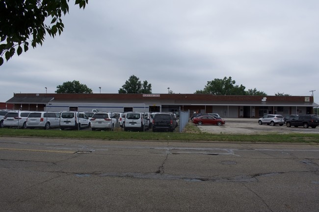

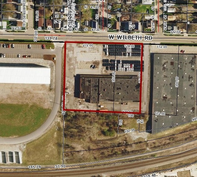
Property Detail
866 W Wilbeth Rd
Akron, OH
TR 2 LOT 10 S OF WILBETH RD 3.210A
67-35583
Summit
Regionalshoppingcenterormallwithanchorstore
Ohio
2023
10
2025
3.21 AC
505700
Akron
31,820 SF
Cleveland
NEARBY LISTINGS FOR SALE OR LEASE
DEMOGRAPHICS near 866 W Wilbeth Rd
1 mile
3 mile
5 mile
2025 Total Population
12,132
73,193
168,277
2030 Population
12,161
73,473
169,245
Pop Growth 2025-2030
+ 0.24%
+ 0.38%
+ 0.58%
Average Age
39
41
40
2025 Total Households
5,165
31,976
72,680
HH Growth 2025-2030
+ 0.19%
+ 0.32%
+ 0.54%
Median Household Inc
$47,163
$46,670
$46,673
Avg Household Size
2.30
2.20
2.20
2025 Avg HH Vehicles
2.00
2.00
2.00
Median Home Value
$80,809
$118,669
$137,111
Median Year Built
1948
1953
1953
Nearby Places
Map Layers
Map Styles
 Street
 Aerial
Layers
 Traffic
 Biking
Places
Listings with unknown addresses are not visible on the map
- Restaurants
- Banks
- Shops
- Fitness
- Groceries
PUBLIC TRANSPORTATION
COMMUTER RAIL
Drive
Walk
Distance
12 min
4.8 mi
Drive
Walk
Distance
17 min
7.4 mi
AIRPORT
Akron-Canton Regional
Drive
Walk
Distance
Akron-Canton Regional
20 min
13.6 mi
Cleveland-Hopkins International
Drive
Walk
Distance
Cleveland-Hopkins International
57 min
40.4 mi
SALE & LEASE HISTORY
LISTING DATE
SALE/LEASE

Sep 25, 2016
For Lease
Sep 24, 2016
For Sale
Nov 18, 2024
For Sale
Nov 18, 2024
For Lease
Nearby Properties
Address
Land Use
TOTAL SIZE
Lot Size
Zoning
Address
Land Use
TOTAL SIZE
Lot Size
Zoning
1,397,532 SF
92.95 AC
Address
Land Use
TOTAL SIZE
Lot Size
Zoning
252,222 SF
12.65 AC
Address
Land Use
TOTAL SIZE
Lot Size
Zoning
203,458 SF
10.41 AC
Address
Land Use
TOTAL SIZE
Lot Size
Zoning
9.19 AC
Address
Land Use
TOTAL SIZE
Lot Size
Zoning
132,611 SF
3.56 AC
Address
Land Use
TOTAL SIZE
Lot Size
Zoning
91,678 SF
5.24 AC
Address
Land Use
TOTAL SIZE
Lot Size
Zoning
423,125 SF
5.57 AC
Address
Land Use
TOTAL SIZE
Lot Size
Zoning
166,625 SF
11.37 AC
Address
Land Use
TOTAL SIZE
Lot Size
Zoning
227,634 SF
21.46 AC
Address
Land Use
TOTAL SIZE
Lot Size
Zoning
184,791 SF
3.25 AC
Address
Land Use
TOTAL SIZE
Lot Size
Zoning
154,926 SF
12.38 AC
Address
Land Use
TOTAL SIZE
Lot Size
Zoning
127,297 SF
6.03 AC
Address
Land Use
TOTAL SIZE
Lot Size
Zoning
Address
Land Use
TOTAL SIZE
Lot Size
Zoning
121,006 SF
6.09 AC
Address
Land Use
TOTAL SIZE
Lot Size
Zoning
22,977 SF
263.47 AC
Address
Land Use
TOTAL SIZE
Lot Size
Zoning
57,180 SF
6.67 AC
Address
Land Use
TOTAL SIZE
Lot Size
Zoning
123,800 SF
76.50 AC
Address
Land Use
TOTAL SIZE
Lot Size
Zoning
54,398 SF
8.10 AC
Address
Land Use
TOTAL SIZE
Lot Size
Zoning
Address
Land Use
TOTAL SIZE
Lot Size
Zoning
148.10 AC
Address
Land Use
TOTAL SIZE
Lot Size
Zoning
51,520 SF
2.70 AC
Address
Land Use
TOTAL SIZE
Lot Size
Zoning
52,640 SF
0.42 AC
Address
Land Use
TOTAL SIZE
Lot Size
Zoning
126,708 SF
3.26 AC
Address
Land Use
TOTAL SIZE
Lot Size
Zoning
232,425 SF
13.37 AC
Address
Land Use
TOTAL SIZE
Lot Size
Zoning
81,108 SF
3.86 AC
Address
Land Use
TOTAL SIZE
Lot Size
Zoning
65,436 SF
34.63 AC
Address
Land Use
TOTAL SIZE
Lot Size
Zoning
130,893 SF
11.70 AC
Address
Land Use
TOTAL SIZE
Lot Size
Zoning
59,492 SF
5.51 AC
Address
Land Use
TOTAL SIZE
Lot Size
Zoning
5.99 AC
Address
Land Use
TOTAL SIZE
Lot Size
Zoning
63,918 SF
4.95 AC
The World's #1 Commercial Real Estate Marketplace
Connect with us
© 2026 CoStar Group
The information above has been obtained from sources believed reliable. While we do not doubt its accuracy we have not verified it and make no guarantee, warranty or representation about it. It is your responsibility to independently confirm its accuracy and completeness. Any projections, opinions, assumptions, or estimates used are for example only and do not represent the current or future performance of the property. The value of this transaction to you depends on tax and other factors which should be evaluated by your tax, financial, and legal advisors. You and your advisors should conduct a careful, independent investigation of the property to determine to your satisfaction the suitability of the property for your needs.