Property Record
8660 183A Toll Rd, Leander, TX 78641


Property Detail
8660 183A Toll Rd
R031359
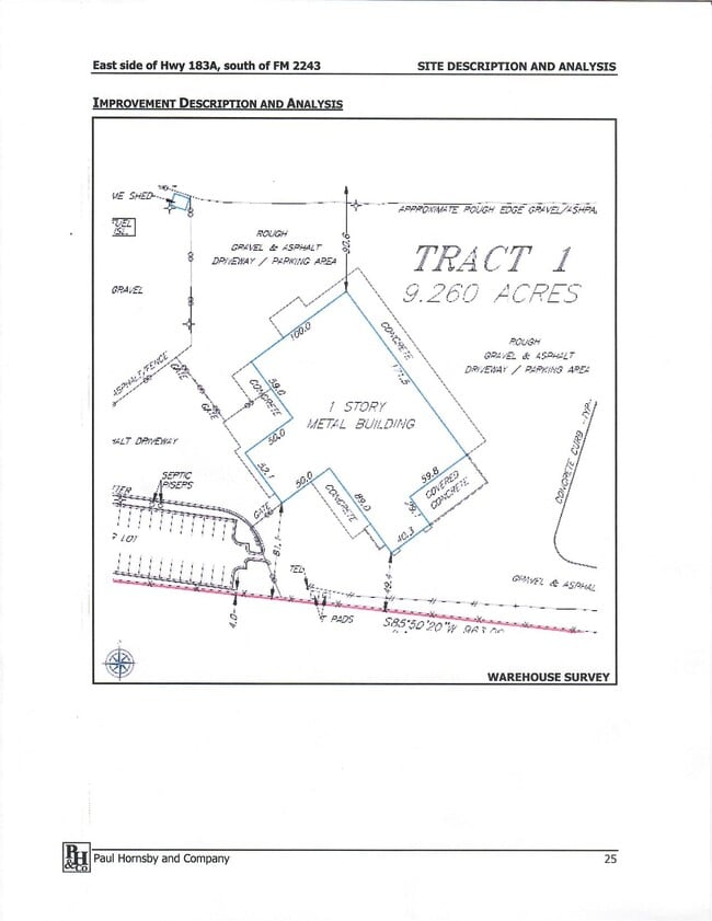
AW0006 AW0006 - HARMON, E. D. SUR., ACRES 9.26
Commercialnec
WILLIAMSON
B and X Area of moderate flood hazard, usually the area between the limits of the 100-year and 500-year floods.
Texas
2023
9.26 AC
2025
Cedar Park
020339
Austin
21,100 SF
Austin-Round Rock-San Marcos, TX
NEARBY LISTINGS FOR SALE OR LEASE
DEMOGRAPHICS near 8660 183A Toll Rd
1 mile
3 mile
5 mile
2025 Total Population
5,608
66,489
156,615
2030 Population
6,514
77,263
180,957
Pop Growth 2025-2030
+ 16.16%
+ 16.20%
+ 15.54%
Average Age
36
36
37
2025 Total Households
2,115
23,203
54,121
HH Growth 2025-2030
+ 16.45%
+ 16.67%
+ 16.04%
Median Household Inc
$119,604
$126,759
$132,472
Avg Household Size
2.70
2.80
2.90
2025 Avg HH Vehicles
2.00
2.00
2.00
Median Home Value
$487,145
$467,423
$489,048
Median Year Built
2011
2010
2010
Nearby Places
Map Layers
Map Styles
 Street
 Aerial
Transit
 Traffic
 Biking
Places
Listings with unknown addresses are not visible on the map
- Restaurants
- Banks
- Shops
- Fitness
- Groceries
PUBLIC TRANSPORTATION
AIRPORT
Austin-Bergstrom International
Drive
Walk
Distance
Austin-Bergstrom International
49 min
36.4 mi
Robert Gray AAF
Drive
Walk
Distance
Robert Gray AAF
54 min
40.8 mi
Killeen Municipal
Drive
Walk
Distance
Killeen Municipal
60 min
49.5 mi
SALE & LEASE HISTORY
LISTING DATE
SALE/LEASE

Jan 24, 2020
For Sale
Nearby Properties
Address
Land Use
TOTAL SIZE
Lot Size
Zoning
Address
Land Use
TOTAL SIZE
Lot Size
Zoning
106,000 SF
72.51 AC
Address
Land Use
TOTAL SIZE
Lot Size
Zoning
341,700 SF
17.71 AC
Address
Land Use
TOTAL SIZE
Lot Size
Zoning
1 SF
138.94 AC
Address
Land Use
TOTAL SIZE
Lot Size
Zoning
287,118 SF
9.26 AC
Address
Land Use
TOTAL SIZE
Lot Size
Zoning
181,000 SF
30.14 AC
Address
Land Use
TOTAL SIZE
Lot Size
Zoning
327,784 SF
22.95 AC
Address
Land Use
TOTAL SIZE
Lot Size
Zoning
310,297 SF
15.01 AC
Address
Land Use
TOTAL SIZE
Lot Size
Zoning
325,045 SF
22.75 AC
Address
Land Use
TOTAL SIZE
Lot Size
Zoning
285,365 SF
12.24 AC
Address
Land Use
TOTAL SIZE
Lot Size
Zoning
333,388 SF
14.04 AC
Address
Land Use
TOTAL SIZE
Lot Size
Zoning
246,060 SF
9.30 AC
Address
Land Use
TOTAL SIZE
Lot Size
Zoning
249,826 SF
37.40 AC
Address
Land Use
TOTAL SIZE
Lot Size
Zoning
238,420 SF
13.72 AC
Address
Land Use
TOTAL SIZE
Lot Size
Zoning
289,565 SF
14.35 AC
Address
Land Use
TOTAL SIZE
Lot Size
Zoning
117,076 SF
15.51 AC
Address
Land Use
TOTAL SIZE
Lot Size
Zoning
238,343 SF
12.08 AC
Address
Land Use
TOTAL SIZE
Lot Size
Zoning
234,214 SF
19.63 AC
Address
Land Use
TOTAL SIZE
Lot Size
Zoning
195,426 SF
12.11 AC
Address
Land Use
TOTAL SIZE
Lot Size
Zoning
249,862 SF
16.14 AC
Address
Land Use
TOTAL SIZE
Lot Size
Zoning
232,172 SF
10.43 AC
Address
Land Use
TOTAL SIZE
Lot Size
Zoning
341,700 SF
9.90 AC
Address
Land Use
TOTAL SIZE
Lot Size
Zoning
316,408 SF
15 AC
Address
Land Use
TOTAL SIZE
Lot Size
Zoning
149,429 SF
16.98 AC
Address
Land Use
TOTAL SIZE
Lot Size
Zoning
193,011 SF
8.91 AC
Address
Land Use
TOTAL SIZE
Lot Size
Zoning
229,977 SF
16.85 AC
Address
Land Use
TOTAL SIZE
Lot Size
Zoning
194,695 SF
9.56 AC
Address
Land Use
TOTAL SIZE
Lot Size
Zoning
191,654 SF
4.57 AC
2-LI
Address
Land Use
TOTAL SIZE
Lot Size
Zoning
251,691 SF
14.73 AC
Address
Land Use
TOTAL SIZE
Lot Size
Zoning
194,695 SF
5.09 AC
Address
Land Use
TOTAL SIZE
Lot Size
Zoning
37.81 AC
The World's #1 Commercial Real Estate Marketplace
Connect with us
© 2026 CoStar Group
The information above has been obtained from sources believed reliable. While we do not doubt its accuracy we have not verified it and make no guarantee, warranty or representation about it. It is your responsibility to independently confirm its accuracy and completeness. Any projections, opinions, assumptions, or estimates used are for example only and do not represent the current or future performance of the property. The value of this transaction to you depends on tax and other factors which should be evaluated by your tax, financial, and legal advisors. You and your advisors should conduct a careful, independent investigation of the property to determine to your satisfaction the suitability of the property for your needs.