Property Record
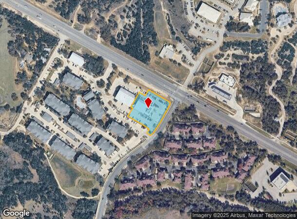
8665 W Highway 71, Austin, TX 78735
NEARBY LISTINGS FOR SALE OR LEASE
Property Detail
8665 W Highway 71
Austin-Round Rock-San Marcos, TX
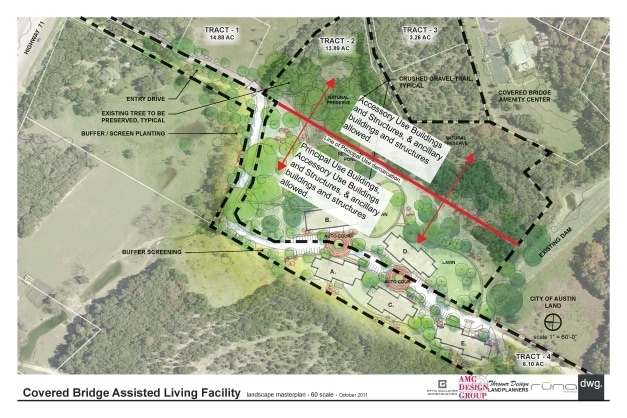
Covered Bridge Whitecrowe Subd
836648
LOT 3A COVERED BRIDGE WHITECROWE SUBD
Stripcommercialcenter
Travis
X
Texas
48453C0560J
3a
2024
1.16 AC
2025
Southwest
033000
Austin
6,400 SF
DEMOGRAPHICS near 8665 W Highway 71
1 mile
3 mile
5 mile
2024 Total Population
8,594
37,843
99,756
2029 Population
9,324
40,697
106,825
Pop Growth 2024-2029
+ 8.49%
+ 7.54%
+ 7.09%
Average Age
38
40
40
2024 Total Households
3,430
15,565
39,865
HH Growth 2024-2029
+ 9.33%
+ 8.32%
+ 7.94%
Median Household Inc
$85,189
$113,184
$122,946
Avg Household Size
2.30
2.30
2.40
2024 Avg HH Vehicles
2.00
2.00
2.00
Median Home Value
$477,521
$583,706
$626,614
Median Year Built
2004
1998
1996
Nearby Places
Map Layers
Map Styles
 Street
 Aerial
Transit
 Traffic
 Biking
Places
Listings with unknown addresses are not visible on the map
- Restaurants
- Banks
- Shops
- Fitness
- Groceries
PUBLIC TRANSPORTATION
AIRPORT
Austin-Bergstrom International
Drive
Walk
Distance
Austin-Bergstrom International
30 min
17.4 mi
Nearby Properties
Address
Land Use
TOTAL SIZE
Lot Size
Zoning
Address
Land Use
TOTAL SIZE
Lot Size
Zoning
881,498 SF
58.79 AC
Address
Land Use
TOTAL SIZE
Lot Size
Zoning
456,600 SF
44.89 AC
Address
Land Use
TOTAL SIZE
Lot Size
Zoning
422,810 SF
46.50 AC
Address
Land Use
TOTAL SIZE
Lot Size
Zoning
359,339 SF
23.59 AC
Address
Land Use
TOTAL SIZE
Lot Size
Zoning
392,093 SF
24.02 AC
Address
Land Use
TOTAL SIZE
Lot Size
Zoning
355,651 SF
31.86 AC
Address
Land Use
TOTAL SIZE
Lot Size
Zoning
286,988 SF
27.73 AC
Address
Land Use
TOTAL SIZE
Lot Size
Zoning
258,600 SF
36.81 AC
Address
Land Use
TOTAL SIZE
Lot Size
Zoning
324,135 SF
53.12 AC
Address
Land Use
TOTAL SIZE
Lot Size
Zoning
267,928 SF
18.13 AC
Address
Land Use
TOTAL SIZE
Lot Size
Zoning
339,456 SF
32.70 AC
Address
Land Use
TOTAL SIZE
Lot Size
Zoning
253,902 SF
28.21 AC
Address
Land Use
TOTAL SIZE
Lot Size
Zoning
278,740 SF
44.30 AC
Address
Land Use
TOTAL SIZE
Lot Size
Zoning
240,640 SF
14.36 AC
Address
Land Use
TOTAL SIZE
Lot Size
Zoning
262,421 SF
33.65 AC
Address
Land Use
TOTAL SIZE
Lot Size
Zoning
150,975 SF
35.79 AC
Address
Land Use
TOTAL SIZE
Lot Size
Zoning
295,322 SF
23.02 AC
Address
Land Use
TOTAL SIZE
Lot Size
Zoning
267,156 SF
45.30 AC
Address
Land Use
TOTAL SIZE
Lot Size
Zoning
82,326 SF
53.78 AC
Address
Land Use
TOTAL SIZE
Lot Size
Zoning
199,816 SF
20.10 AC
Address
Land Use
TOTAL SIZE
Lot Size
Zoning
1,759,639 SF
153.30 AC
Address
Land Use
TOTAL SIZE
Lot Size
Zoning
250,211 SF
21.60 AC
Address
Land Use
TOTAL SIZE
Lot Size
Zoning
161,111 SF
29.24 AC
Address
Land Use
TOTAL SIZE
Lot Size
Zoning
194,230 SF
11.25 AC
Address
Land Use
TOTAL SIZE
Lot Size
Zoning
72,350 SF
3.05 AC
Address
Land Use
TOTAL SIZE
Lot Size
Zoning
129,313 SF
7.45 AC
Address
Land Use
TOTAL SIZE
Lot Size
Zoning
71,786 SF
16.01 AC
Address
Land Use
TOTAL SIZE
Lot Size
Zoning
148,331 SF
19.98 AC
Address
Land Use
TOTAL SIZE
Lot Size
Zoning
136,564 SF
11.08 AC
Address
Land Use
TOTAL SIZE
Lot Size
Zoning
82,730 SF
53.28 AC
The World's #1 Commercial Real Estate Marketplace
Connect with us
© 2026 CoStar Group
The information above has been obtained from sources believed reliable. While we do not doubt its accuracy we have not verified it and make no guarantee, warranty or representation about it. It is your responsibility to independently confirm its accuracy and completeness. Any projections, opinions, assumptions, or estimates used are for example only and do not represent the current or future performance of the property. The value of this transaction to you depends on tax and other factors which should be evaluated by your tax, financial, and legal advisors. You and your advisors should conduct a careful, independent investigation of the property to determine to your satisfaction the suitability of the property for your needs.