Property Record
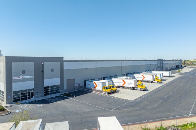
8670 Fruitridge Rd, Sacramento, CA 95826


Current Lease Availabilities
NEARBY LISTINGS FOR SALE OR LEASE
Property Detail
8670 Fruitridge Rd
062-0100-027
Certificate Of Compliance For Lot Line A
Shipyard
ALL THAT CERTAIN REAL PROPERTY SITUATE IN THE CITY OF SACRAMENTO, COUNTY OF SACRAMENTO, STATE OF CALIFORNIA, DESCRIBED AS FOLLOWS:ALL THAT PORTION OF THE EAST 1/2 OF THE NORTHWEST 1/4 OF SECTION 25, TOWNSHIP 8 NORTH, RANGE 5 EAST, MOUNT DIA
X
Sacramento
06067C0195H
California
2024
13.67 AC
2025
Power Inn
009201
Sacramento
240,255 SF
Sacramento-Roseville-Folsom, CA
DEMOGRAPHICS near 8670 Fruitridge Rd
1 Mile
3 Mile
5 Mile
2024 Total Population
49
96,185
331,443
2029 Population
47
96,928
333,836
Pop Growth 2024-2029
(4.08%)
+ 0.77%
+ 0.72%
Average Age
43
38
38
2024 Total Households
16
33,194
115,571
HH Growth 2024-2029
0.00%
+ 0.85%
+ 0.76%
Median Household Inc
$67,500
$67,609
$68,023
Avg Household Size
2.60
2.70
2.70
2024 Avg HH Vehicles
3.00
2.00
2.00
Median Home Value
$625,000
$372,143
$415,052
Median Year Built
1956
1974
1974
Nearby Places
Map Layers
Map Styles
 Street
 Aerial
- Restaurants
- Banks
- Shops
- Fitness
- Groceries
PUBLIC TRANSPORTATION
AIRPORT
Sacramento International
DRIVE
WALK
Distance
Sacramento International
26 min
20.9 mi
Freight Ports
Port of Richmond
DRIVE
WALK
Distance
Port of Richmond
1 min
68.3 mi
Nearby Properties
Address
Land Use
TOTAL SIZE
Lot Size
Zoning
Address
Land Use
TOTAL SIZE
Lot Size
Zoning
7,742 SF
12.66 AC
M-1S-SWR
Address
Land Use
TOTAL SIZE
Lot Size
Zoning
2,317,288 SF
220.58 AC
M-2-SPD
Address
Land Use
TOTAL SIZE
Lot Size
Zoning
9.29 AC
R-1 OB-R-P
Address
Land Use
TOTAL SIZE
Lot Size
Zoning
350,049 SF
8.51 AC
MRD-SWR
Address
Land Use
TOTAL SIZE
Lot Size
Zoning
45.93 AC
M-2S
Address
Land Use
TOTAL SIZE
Lot Size
Zoning
281,448 SF
13.42 AC
RMX-TO R-2
Address
Land Use
TOTAL SIZE
Lot Size
Zoning
149,566 SF
9.68 AC
M-2S
Address
Land Use
TOTAL SIZE
Lot Size
Zoning
119,380 SF
18.92 AC
M-2S
Address
Land Use
TOTAL SIZE
Lot Size
Zoning
187,080 SF
10.01 AC
SPA M-1
Address
Land Use
TOTAL SIZE
Lot Size
Zoning
156,462 SF
8.36 AC
R-3
Address
Land Use
TOTAL SIZE
Lot Size
Zoning
40.67 AC
M-2-SPD
Address
Land Use
TOTAL SIZE
Lot Size
Zoning
584,820 SF
29.12 AC
M-2S
Address
Land Use
TOTAL SIZE
Lot Size
Zoning
198,112 SF
19.62 AC
M-1 M-1 (N
Address
Land Use
TOTAL SIZE
Lot Size
Zoning
7.55 AC
SPA
Address
Land Use
TOTAL SIZE
Lot Size
Zoning
345,600 SF
14.84 AC
M-1S-SWR
Address
Land Use
TOTAL SIZE
Lot Size
Zoning
164,981 SF
3.95 AC
OB-SWR-PUD
Address
Land Use
TOTAL SIZE
Lot Size
Zoning
192,308 SF
5.42 AC
C-2
Address
Land Use
TOTAL SIZE
Lot Size
Zoning
303,950 SF
19.34 AC
R-2A-R
Address
Land Use
TOTAL SIZE
Lot Size
Zoning
261,350 SF
14.41 AC
M-2S
Address
Land Use
TOTAL SIZE
Lot Size
Zoning
168,846 SF
7.58 AC
RD-30 (PC)
Address
Land Use
TOTAL SIZE
Lot Size
Zoning
319,485 SF
16.35 AC
M-2S
Address
Land Use
TOTAL SIZE
Lot Size
Zoning
119,824 SF
7.64 AC
RD-30 (PC)
Address
Land Use
TOTAL SIZE
Lot Size
Zoning
159,121 SF
10.38 AC
C-2-TO
Address
Land Use
TOTAL SIZE
Lot Size
Zoning
135,375 SF
7.40 AC
RD-30
Address
Land Use
TOTAL SIZE
Lot Size
Zoning
158,710 SF
14.02 AC
M-1 (NPA)
Address
Land Use
TOTAL SIZE
Lot Size
Zoning
198,131 SF
13.36 AC
BP
Address
Land Use
TOTAL SIZE
Lot Size
Zoning
271,016 SF
15.54 AC
R-2B-PUD
Address
Land Use
TOTAL SIZE
Lot Size
Zoning
87,402 SF
3.94 AC
R-3
Address
Land Use
TOTAL SIZE
Lot Size
Zoning
269,952 SF
14.87 AC
R-2B-PUD
Address
Land Use
TOTAL SIZE
Lot Size
Zoning
138,779 SF
44.77 AC
M-2S
The World's #1 Commercial Real Estate Marketplace
Connect with us
© 2026 CoStar Group
The information above has been obtained from sources believed reliable. While we do not doubt its accuracy we have not verified it and make no guarantee, warranty or representation about it. It is your responsibility to independently confirm its accuracy and completeness. Any projections, opinions, assumptions, or estimates used are for example only and do not represent the current or future performance of the property. The value of this transaction to you depends on tax and other factors which should be evaluated by your tax, financial, and legal advisors. You and your advisors should conduct a careful, independent investigation of the property to determine to your satisfaction the suitability of the property for your needs.