Property Record
8680 Stonebrook Pkwy, Frisco, TX 75034
Property Detail
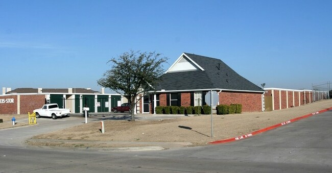
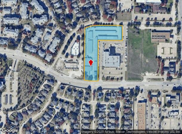
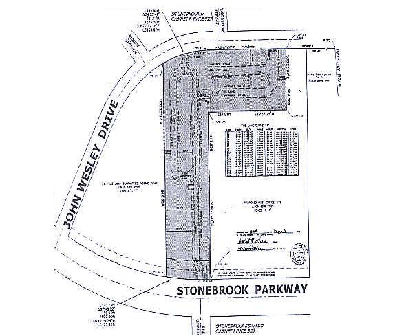
8680 Stonebrook Pkwy
R-3417-000-0000-1
Stonebrook Self Storage (Cfr)
Commercialnec
STONEBROOK SELF STORAGE
X
Collin
48085C0245K
Texas
2024
3.06 AC
2025
Frisco/The Colony
030409
Dallas/Ft Worth
59,950 SF
Dallas-Fort Worth-Arlington, TX
NEARBY LISTINGS FOR SALE OR LEASE
DEMOGRAPHICS near 8680 Stonebrook Pkwy
1 mile
3 mile
5 mile
2024 Total Population
17,869
109,265
324,329
2029 Population
21,673
134,576
396,219
Pop Growth 2024-2029
+ 21.29%
+ 23.16%
+ 22.17%
Average Age
37
37
36
2024 Total Households
7,340
42,718
114,429
HH Growth 2024-2029
+ 21.44%
+ 23.62%
+ 22.65%
Median Household Inc
$70,947
$105,589
$127,667
Avg Household Size
2.40
2.50
2.80
2024 Avg HH Vehicles
2.00
2.00
2.00
Median Home Value
$351,496
$457,824
$479,407
Median Year Built
2000
2007
2007
Nearby Places
Map Layers
Map Styles
 Street
 Aerial
Transit
 Traffic
 Biking
Places
Listings with unknown addresses are not visible on the map
- Restaurants
- Banks
- Shops
- Fitness
- Groceries
PUBLIC TRANSPORTATION
AIRPORT
Dallas Love Field
Drive
Walk
Distance
Dallas Love Field
33 min
24.7 mi
Dallas-Fort Worth International
Drive
Walk
Distance
Dallas-Fort Worth International
31 min
25.5 mi
Freight Ports
Port of Shreveport
Drive
Walk
Distance
Port of Shreveport
236 min
218.1 mi
Nearby Properties
Address
Land Use
TOTAL SIZE
Lot Size
Zoning
Address
Land Use
TOTAL SIZE
Lot Size
Zoning
1,316,483 SF
47.52 AC
Address
Land Use
TOTAL SIZE
Lot Size
Zoning
525,388 SF
5.01 AC
Address
Land Use
TOTAL SIZE
Lot Size
Zoning
358,447 SF
40.21 AC
Address
Land Use
TOTAL SIZE
Lot Size
Zoning
975,081 SF
15.33 AC
Address
Land Use
TOTAL SIZE
Lot Size
Zoning
525,405 SF
5.09 AC
Address
Land Use
TOTAL SIZE
Lot Size
Zoning
741,280 SF
90.87 AC
Address
Land Use
TOTAL SIZE
Lot Size
Zoning
358,496 SF
2.49 AC
Address
Land Use
TOTAL SIZE
Lot Size
Zoning
325,179 SF
4.74 AC
COMM
Address
Land Use
TOTAL SIZE
Lot Size
Zoning
318,230 SF
5.52 AC
Address
Land Use
TOTAL SIZE
Lot Size
Zoning
761,346 SF
75.86 AC
Address
Land Use
TOTAL SIZE
Lot Size
Zoning
351,604 SF
3.17 AC
Address
Land Use
TOTAL SIZE
Lot Size
Zoning
454,511 SF
52.88 AC
COMM
Address
Land Use
TOTAL SIZE
Lot Size
Zoning
535,339 SF
54.76 AC
Address
Land Use
TOTAL SIZE
Lot Size
Zoning
661,922 SF
13.53 AC
COMM
Address
Land Use
TOTAL SIZE
Lot Size
Zoning
556,032 SF
24.46 AC
MF-M
Address
Land Use
TOTAL SIZE
Lot Size
Zoning
235,855 SF
3.38 AC
Address
Land Use
TOTAL SIZE
Lot Size
Zoning
326,967 SF
1.36 AC
Address
Land Use
TOTAL SIZE
Lot Size
Zoning
489,385 SF
10.24 AC
Address
Land Use
TOTAL SIZE
Lot Size
Zoning
492,430 SF
6.66 AC
MF-E
Address
Land Use
TOTAL SIZE
Lot Size
Zoning
314,093 SF
1.94 AC
MF-E
Address
Land Use
TOTAL SIZE
Lot Size
Zoning
212,698 SF
10.48 AC
Address
Land Use
TOTAL SIZE
Lot Size
Zoning
369,122 SF
3.06 AC
MF-R
Address
Land Use
TOTAL SIZE
Lot Size
Zoning
431,308 SF
4.28 AC
COMM
Address
Land Use
TOTAL SIZE
Lot Size
Zoning
236,513 SF
99.95 AC
Address
Land Use
TOTAL SIZE
Lot Size
Zoning
417,369 SF
5.65 AC
MF-E
Address
Land Use
TOTAL SIZE
Lot Size
Zoning
529,149 SF
9.21 AC
MF-E
Address
Land Use
TOTAL SIZE
Lot Size
Zoning
329,460 SF
63.31 AC
Address
Land Use
TOTAL SIZE
Lot Size
Zoning
304,601 SF
6.11 AC
Address
Land Use
TOTAL SIZE
Lot Size
Zoning
238,464 SF
2.68 AC
Address
Land Use
TOTAL SIZE
Lot Size
Zoning
138.63 AC
The World's #1 Commercial Real Estate Marketplace
Connect with us
© 2026 CoStar Group
The information above has been obtained from sources believed reliable. While we do not doubt its accuracy we have not verified it and make no guarantee, warranty or representation about it. It is your responsibility to independently confirm its accuracy and completeness. Any projections, opinions, assumptions, or estimates used are for example only and do not represent the current or future performance of the property. The value of this transaction to you depends on tax and other factors which should be evaluated by your tax, financial, and legal advisors. You and your advisors should conduct a careful, independent investigation of the property to determine to your satisfaction the suitability of the property for your needs.