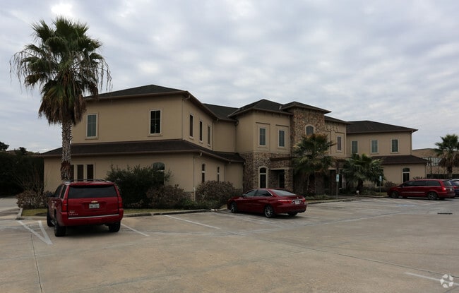
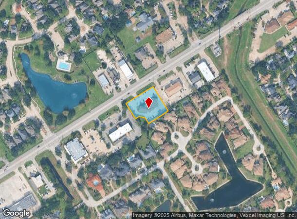
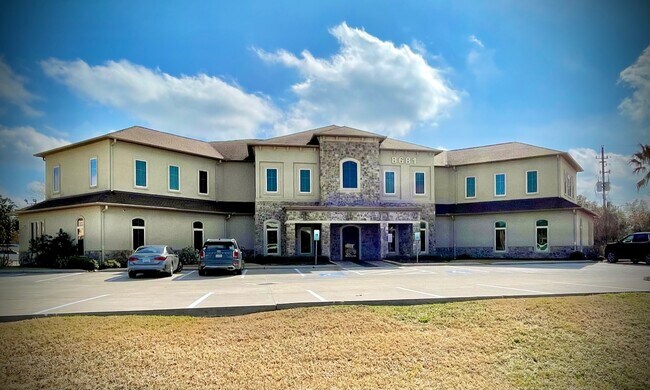
Property Record
8681 Louetta Rd, Spring, TX 77379
NEARBY LISTINGS FOR SALE OR LEASE
Property Detail
8681 Louetta Rd
1244360010015
Lakes Of Steling Gate Sec 2
Medicalbuilding
RES A1 BLK 1 LAKES OF STELING GATE SEC 2
X
Harris
48201C0245M
Texas
2024
0.93 AC
2025
FM 1960/Champions
554002
Houston
10,919 SF
Houston-Pasadena-The Woodlands, TX
DEMOGRAPHICS near 8681 Louetta Rd
1 Mile
3 Mile
5 Mile
2024 Total Population
13,847
102,503
284,583
2029 Population
13,965
104,312
289,335
Pop Growth 2024-2029
+ 0.85%
+ 1.76%
+ 1.67%
Average Age
42
39
38
2024 Total Households
4,931
38,640
100,255
HH Growth 2024-2029
+ 0.85%
+ 1.81%
+ 1.67%
Median Household Inc
$109,905
$81,670
$81,036
Avg Household Size
2.80
2.60
2.80
2024 Avg HH Vehicles
2.00
2.00
2.00
Median Home Value
$281,279
$278,761
$261,971
Median Year Built
1988
1992
1995
Nearby Places
Map Layers
Map Styles
 Street
 Aerial
- Restaurants
- Banks
- Shops
- Fitness
- Groceries
PUBLIC TRANSPORTATION
AIRPORT
George Bush Intcntl/Houston
DRIVE
WALK
Distance
George Bush Intcntl/Houston
28 min
19.2 mi
William P Hobby
DRIVE
WALK
Distance
William P Hobby
56 min
34.7 mi
Freight Ports
Port of Houston
DRIVE
WALK
Distance
Port of Houston
48 min
30.3 mi
SALE & LEASE HISTORY
LISTING DATE
SALE/LEASE

Jan 04, 2023
For Lease
Nearby Properties
Address
Land Use
TOTAL SIZE
Lot Size
Zoning
Address
Land Use
TOTAL SIZE
Lot Size
Zoning
1,648,539 SF
28.70 AC
Address
Land Use
TOTAL SIZE
Lot Size
Zoning
339,067 SF
34.40 AC
Address
Land Use
TOTAL SIZE
Lot Size
Zoning
427,317 SF
14.16 AC
Address
Land Use
TOTAL SIZE
Lot Size
Zoning
1,073,104 SF
4.74 AC
Address
Land Use
TOTAL SIZE
Lot Size
Zoning
227,400 SF
2.77 AC
Address
Land Use
TOTAL SIZE
Lot Size
Zoning
386,754 SF
17.99 AC
Address
Land Use
TOTAL SIZE
Lot Size
Zoning
341,895 SF
17.53 AC
Address
Land Use
TOTAL SIZE
Lot Size
Zoning
507,035 SF
24.90 AC
Address
Land Use
TOTAL SIZE
Lot Size
Zoning
402,504 SF
31.93 AC
Address
Land Use
TOTAL SIZE
Lot Size
Zoning
551,524 SF
10.06 AC
Address
Land Use
TOTAL SIZE
Lot Size
Zoning
267,094 SF
14.76 AC
Address
Land Use
TOTAL SIZE
Lot Size
Zoning
486,739 SF
19.92 AC
Address
Land Use
TOTAL SIZE
Lot Size
Zoning
262,163 SF
8.63 AC
Address
Land Use
TOTAL SIZE
Lot Size
Zoning
405,225 SF
18.34 AC
Address
Land Use
TOTAL SIZE
Lot Size
Zoning
423,472 SF
28.91 AC
Address
Land Use
TOTAL SIZE
Lot Size
Zoning
256,761 SF
8.78 AC
Address
Land Use
TOTAL SIZE
Lot Size
Zoning
267,082 SF
11.13 AC
Address
Land Use
TOTAL SIZE
Lot Size
Zoning
260,253 SF
7.46 AC
Address
Land Use
TOTAL SIZE
Lot Size
Zoning
377,188 SF
16.80 AC
Address
Land Use
TOTAL SIZE
Lot Size
Zoning
371,761 SF
12.71 AC
Address
Land Use
TOTAL SIZE
Lot Size
Zoning
181,542 SF
8 AC
Address
Land Use
TOTAL SIZE
Lot Size
Zoning
308,141 SF
17.64 AC
Address
Land Use
TOTAL SIZE
Lot Size
Zoning
335,954 SF
35.27 AC
Address
Land Use
TOTAL SIZE
Lot Size
Zoning
80,004 SF
4.41 AC
Address
Land Use
TOTAL SIZE
Lot Size
Zoning
300,080 SF
13.86 AC
Address
Land Use
TOTAL SIZE
Lot Size
Zoning
348,658 SF
16.72 AC
Address
Land Use
TOTAL SIZE
Lot Size
Zoning
148,450 SF
18.26 AC
Address
Land Use
TOTAL SIZE
Lot Size
Zoning
295,201 SF
14.31 AC
Address
Land Use
TOTAL SIZE
Lot Size
Zoning
329,812 SF
19.14 AC
Address
Land Use
TOTAL SIZE
Lot Size
Zoning
314,385 SF
13.78 AC
The World's #1 Commercial Real Estate Marketplace
Connect with us
© 2026 CoStar Group
The information above has been obtained from sources believed reliable. While we do not doubt its accuracy we have not verified it and make no guarantee, warranty or representation about it. It is your responsibility to independently confirm its accuracy and completeness. Any projections, opinions, assumptions, or estimates used are for example only and do not represent the current or future performance of the property. The value of this transaction to you depends on tax and other factors which should be evaluated by your tax, financial, and legal advisors. You and your advisors should conduct a careful, independent investigation of the property to determine to your satisfaction the suitability of the property for your needs.