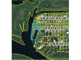
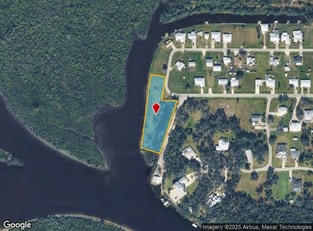
Property Record
8682 Sw Riviera Dr, Arcadia, FL 34269
NEARBY LISTINGS FOR SALE OR LEASE
Property Detail
8682 Sw Riviera Dr
Arcadia, FL
Sunny Breeze Harbor
35-39-23-0367-0010-0010
SUNNY BREEZE HARBOR SEC 10A LOT 1 BLK 1 TOGETHER WITH PARCEL A INST:201414001084 INST:202014007839 INST:202314010176 INST:202414002344
Vacantlandnec
DeSoto
AE
Florida
12015C0086G
1
2024
0.22 AC
2024
Florida Central South Area
010405
Other Market Areas
DEMOGRAPHICS near 8682 Sw Riviera Dr
1 Mile
3 Mile
5 Mile
2024 Total Population
552
9,231
29,569
2029 Population
584
10,732
35,012
Pop Growth 2024-2029
+ 5.80%
+ 16.26%
+ 18.41%
Average Age
56
51
53
2024 Total Households
256
4,014
13,620
HH Growth 2024-2029
+ 6.64%
+ 16.59%
+ 18.79%
Median Household Inc
$47,727
$54,132
$57,228
Avg Household Size
2.00
2.20
2.10
2024 Avg HH Vehicles
1.00
2.00
2.00
Median Home Value
$113,043
$248,150
$249,105
Median Year Built
1990
1993
1995
Nearby Places
Map Layers
Map Styles
 Street
 Aerial
- Restaurants
- Banks
- Shops
- Fitness
- Groceries
PUBLIC TRANSPORTATION
AIRPORT
Punta Gorda
DRIVE
WALK
Distance
Punta Gorda
27 min
14.3 mi
Freight Ports
Port Manatee
DRIVE
WALK
Distance
Port Manatee
103 min
76.5 mi
Nearby Properties
Address
Land Use
TOTAL SIZE
Lot Size
Zoning
Address
Land Use
TOTAL SIZE
Lot Size
Zoning
1,225,024 SF
170.84 AC
IL
Address
Land Use
TOTAL SIZE
Lot Size
Zoning
2,148 SF
121.95 AC
PD
Address
Land Use
TOTAL SIZE
Lot Size
Zoning
15,866 SF
63.03 AC
TTRVC
Address
Land Use
TOTAL SIZE
Lot Size
Zoning
8,044 SF
29.55 AC
TTRVC
Address
Land Use
TOTAL SIZE
Lot Size
Zoning
23,566 SF
20.33 AC
RMF10
Address
Land Use
TOTAL SIZE
Lot Size
Zoning
2,025 SF
28.05 AC
RVC
Address
Land Use
TOTAL SIZE
Lot Size
Zoning
9,908 SF
40 AC
RVC
Address
Land Use
TOTAL SIZE
Lot Size
Zoning
14,945 SF
2.47 AC
RMF15
Address
Land Use
TOTAL SIZE
Lot Size
Zoning
11,248 SF
91.25 AC
RMF15
Address
Land Use
TOTAL SIZE
Lot Size
Zoning
172.19 AC
PUD
Address
Land Use
TOTAL SIZE
Lot Size
Zoning
509 AC
A-5
Address
Land Use
TOTAL SIZE
Lot Size
Zoning
3,248 SF
21.20 AC
MHP
Address
Land Use
TOTAL SIZE
Lot Size
Zoning
27,214 SF
7.92 AC
A-5
Address
Land Use
TOTAL SIZE
Lot Size
Zoning
8,015 SF
2.16 AC
RMF15
Address
Land Use
TOTAL SIZE
Lot Size
Zoning
432 SF
20 AC
A-5
Address
Land Use
TOTAL SIZE
Lot Size
Zoning
4,800 SF
40.53 AC
PUD
Address
Land Use
TOTAL SIZE
Lot Size
Zoning
499.70 AC
A-5
Address
Land Use
TOTAL SIZE
Lot Size
Zoning
501.85 AC
A-5
Address
Land Use
TOTAL SIZE
Lot Size
Zoning
23,142 SF
5 AC
A-5
Address
Land Use
TOTAL SIZE
Lot Size
Zoning
480 AC
A-5
Address
Land Use
TOTAL SIZE
Lot Size
Zoning
33.42 AC
PUD
Address
Land Use
TOTAL SIZE
Lot Size
Zoning
10,972 SF
1.40 AC
RMF15
Address
Land Use
TOTAL SIZE
Lot Size
Zoning
8,823 SF
73.60 AC
RE1
Address
Land Use
TOTAL SIZE
Lot Size
Zoning
8,838 SF
2.43 AC
RMF-6
Address
Land Use
TOTAL SIZE
Lot Size
Zoning
18.83 AC
RVC
Address
Land Use
TOTAL SIZE
Lot Size
Zoning
9,714 SF
10 AC
RMF-M
Address
Land Use
TOTAL SIZE
Lot Size
Zoning
10,935 SF
5 AC
CG
Address
Land Use
TOTAL SIZE
Lot Size
Zoning
21.25 AC
A-5
Address
Land Use
TOTAL SIZE
Lot Size
Zoning
10,086 SF
40.88 AC
RMF-6
Address
Land Use
TOTAL SIZE
Lot Size
Zoning
7,050 SF
4.49 AC
RSF-3
The World's #1 Commercial Real Estate Marketplace
Connect with us
© 2025 CoStar Group
The information above has been obtained from sources believed reliable. While we do not doubt its accuracy we have not verified it and make no guarantee, warranty or representation about it. It is your responsibility to independently confirm its accuracy and completeness. Any projections, opinions, assumptions, or estimates used are for example only and do not represent the current or future performance of the property. The value of this transaction to you depends on tax and other factors which should be evaluated by your tax, financial, and legal advisors. You and your advisors should conduct a careful, independent investigation of the property to determine to your satisfaction the suitability of the property for your needs.