Property Record
8683 Fort Hamer Rd, Parrish, FL 34219
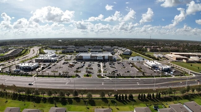

Property Detail
8683 Fort Hamer Rd
North Port-Bradenton-Sarasota, FL
LOT 3, MORGANS GLEN COMMERCIAL PI # 4036.2265/9
4036-2265-9
MANATEE
Storemultistory
Florida
2023
3
2025
3.92 AC
001913
Manatee
25,842 SF
Tampa/St Petersburg
NEARBY LISTINGS FOR SALE OR LEASE
-
-
View all Parrish listings for lease on LoopNet.com
DEMOGRAPHICS near 8683 Fort Hamer Rd
1 mile
3 mile
5 mile
2025 Total Population
4,513
26,780
62,008
2030 Population
5,551
31,740
72,063
Pop Growth 2025-2030
+ 23.00%
+ 18.52%
+ 16.22%
Average Age
36
40
45
2025 Total Households
1,370
8,844
23,217
HH Growth 2025-2030
+ 22.34%
+ 17.47%
+ 15.70%
Median Household Inc
$122,849
$113,831
$104,811
Avg Household Size
3.10
2.80
2.60
2025 Avg HH Vehicles
2.00
2.00
2.00
Median Home Value
$477,205
$446,664
$442,111
Median Year Built
2011
2010
2010
Nearby Places
Map Layers
Map Styles
 Street
 Aerial
Layers
 Traffic
 Biking
Places
Listings with unknown addresses are not visible on the map
- Restaurants
- Banks
- Shops
- Fitness
- Groceries
PUBLIC TRANSPORTATION
AIRPORT
Sarasota/Bradenton International
Drive
Walk
Distance
Sarasota/Bradenton International
39 min
22.5 mi
St Pete-Clearwater International
Drive
Walk
Distance
St Pete-Clearwater International
57 min
39.0 mi
Tampa International
Drive
Walk
Distance
Tampa International
62 min
48.5 mi
Freight Ports
Port Manatee
Drive
Walk
Distance
Port Manatee
19 min
10.2 mi
SALE & LEASE HISTORY
LISTING DATE
SALE/LEASE

Nov 25, 2025
For Lease
Nearby Properties
Address
Land Use
TOTAL SIZE
Lot Size
Zoning
Address
Land Use
TOTAL SIZE
Lot Size
Zoning
137.34 AC
Address
Land Use
TOTAL SIZE
Lot Size
Zoning
165.96 AC
Address
Land Use
TOTAL SIZE
Lot Size
Zoning
136.89 AC
Address
Land Use
TOTAL SIZE
Lot Size
Zoning
Address
Land Use
TOTAL SIZE
Lot Size
Zoning
50.25 AC
Address
Land Use
TOTAL SIZE
Lot Size
Zoning
64,800 SF
8.19 AC
Address
Land Use
TOTAL SIZE
Lot Size
Zoning
58,569 SF
19.67 AC
A GENERAL
Address
Land Use
TOTAL SIZE
Lot Size
Zoning
66,063 SF
9.24 AC
PD-C
Address
Land Use
TOTAL SIZE
Lot Size
Zoning
158.58 AC
Address
Land Use
TOTAL SIZE
Lot Size
Zoning
89,799 SF
22.19 AC
PD-C
Address
Land Use
TOTAL SIZE
Lot Size
Zoning
43,464 SF
14.47 AC
VIL VILLAG
Address
Land Use
TOTAL SIZE
Lot Size
Zoning
43.81 AC
Address
Land Use
TOTAL SIZE
Lot Size
Zoning
50,580 SF
5.97 AC
Address
Land Use
TOTAL SIZE
Lot Size
Zoning
2.73 AC
Address
Land Use
TOTAL SIZE
Lot Size
Zoning
Address
Land Use
TOTAL SIZE
Lot Size
Zoning
53,851 SF
6.32 AC
Address
Land Use
TOTAL SIZE
Lot Size
Zoning
30,101 SF
13.44 AC
PD-C
Address
Land Use
TOTAL SIZE
Lot Size
Zoning
76.98 AC
Address
Land Use
TOTAL SIZE
Lot Size
Zoning
23,742 SF
5.21 AC
A-1 SUBURB
Address
Land Use
TOTAL SIZE
Lot Size
Zoning
36,700 SF
17 AC
A-1 SUBURB
Address
Land Use
TOTAL SIZE
Lot Size
Zoning
44,874 SF
394.53 AC
PD-PI
Address
Land Use
TOTAL SIZE
Lot Size
Zoning
109.06 AC
Address
Land Use
TOTAL SIZE
Lot Size
Zoning
3.11 AC
Address
Land Use
TOTAL SIZE
Lot Size
Zoning
53,448 SF
3 AC
PD-C
Address
Land Use
TOTAL SIZE
Lot Size
Zoning
44.29 AC
Address
Land Use
TOTAL SIZE
Lot Size
Zoning
Address
Land Use
TOTAL SIZE
Lot Size
Zoning
30.70 AC
Address
Land Use
TOTAL SIZE
Lot Size
Zoning
Address
Land Use
TOTAL SIZE
Lot Size
Zoning
9,806 SF
4.04 AC
VIL VILLAG
The World's #1 Commercial Real Estate Marketplace
Connect with us
© 2026 CoStar Group
The information above has been obtained from sources believed reliable. While we do not doubt its accuracy we have not verified it and make no guarantee, warranty or representation about it. It is your responsibility to independently confirm its accuracy and completeness. Any projections, opinions, assumptions, or estimates used are for example only and do not represent the current or future performance of the property. The value of this transaction to you depends on tax and other factors which should be evaluated by your tax, financial, and legal advisors. You and your advisors should conduct a careful, independent investigation of the property to determine to your satisfaction the suitability of the property for your needs.