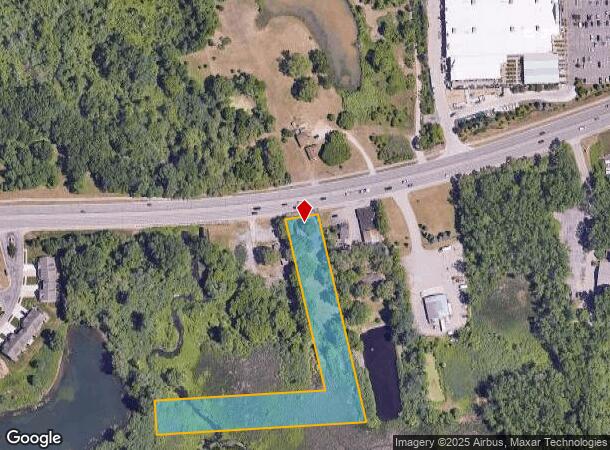
Property Record
8685 Highland Rd, White Lake, MI 48386
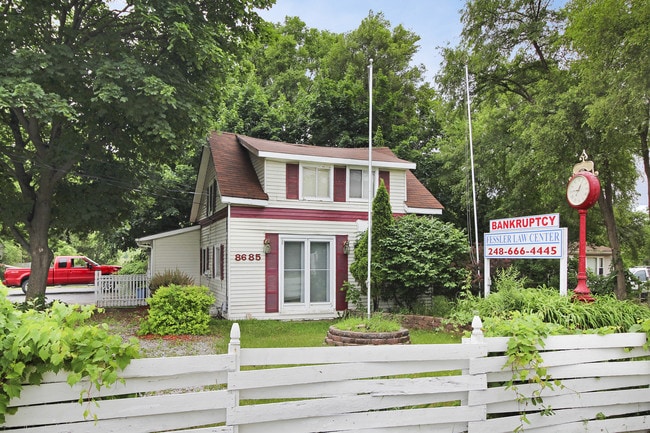
This Property Is For Sale
NEARBY LISTINGS FOR SALE OR LEASE
Property Detail
8685 Highland Rd
12-24-126-002
T3N, R8E, SEC 24 PART OF NE 1/4 OF NW 1/4 BEG AT PT ON SLY LINE M-59 HWY DIST N 87-47-00 W 818.79 FT & S 02-13-00 W 14.29 FT FROM N 1/4 COR, TH S 09-45-00 E 616.09 FT, TH W 617.86 FT TO 1/8 LINE, TH N 01-25-15 E 100.03 FT, TH E 503.71 FT, TH N 09-55-
Officebuilding
Oakland
AE
Michigan
26125C0337F
2.34 AC
2024
St Clair & Lapeer Counties
2024
Detroit
130400
Detroit-Warren-Dearborn, MI
1,041 SF
DEMOGRAPHICS near 8685 Highland Rd
1 Mile
3 Mile
5 Mile
2024 Total Population
4,201
33,935
97,660
2029 Population
4,164
33,702
96,719
Pop Growth 2024-2029
(0.88%)
(0.69%)
(0.96%)
Average Age
46
43
43
2024 Total Households
1,770
14,284
40,042
HH Growth 2024-2029
(0.90%)
(0.75%)
(0.99%)
Median Household Inc
$93,138
$82,260
$84,203
Avg Household Size
2.30
2.30
2.40
2024 Avg HH Vehicles
2.00
2.00
2.00
Median Home Value
$285,645
$264,609
$266,977
Median Year Built
1977
1978
1976
Nearby Places
- Restaurants
- Banks
- Shops
- Fitness
- Groceries
PUBLIC TRANSPORTATION
COMMUTER RAIL
Pontiac Amtrak Station (Wolverine - Amtrak)
DRIVE
WALK
Distance
Pontiac Amtrak Station (Wolverine - Amtrak)
16 min
9.3 mi
AIRPORT
Bishop International
DRIVE
WALK
Distance
Bishop International
51 min
33.0 mi
Freight Ports
Port of Toledo
DRIVE
WALK
Distance
Port of Toledo
101 min
80.4 mi
Nearby Properties
Address
Land Use
TOTAL SIZE
Lot Size
Zoning
Address
Land Use
TOTAL SIZE
Lot Size
Zoning
240,398 SF
23.50 AC
AI
Address
Land Use
TOTAL SIZE
Lot Size
Zoning
190,753 SF
16.54 AC
AI
Address
Land Use
TOTAL SIZE
Lot Size
Zoning
16,640 SF
13.07 AC
ME
Address
Land Use
TOTAL SIZE
Lot Size
Zoning
219,124 SF
18.63 AC
AI
Address
Land Use
TOTAL SIZE
Lot Size
Zoning
86,192 SF
19.27 AC
Address
Land Use
TOTAL SIZE
Lot Size
Zoning
150,669 SF
16.57 AC
AI
Address
Land Use
TOTAL SIZE
Lot Size
Zoning
4,011 SF
53.71 AC
MM
Address
Land Use
TOTAL SIZE
Lot Size
Zoning
151,611 SF
12.16 AC
AI
Address
Land Use
TOTAL SIZE
Lot Size
Zoning
3,908 SF
54.90 AC
MM
Address
Land Use
TOTAL SIZE
Lot Size
Zoning
93,541 SF
21.75 AC
SV
Address
Land Use
TOTAL SIZE
Lot Size
Zoning
119,755 SF
14.03 AC
Address
Land Use
TOTAL SIZE
Lot Size
Zoning
105,874 SF
13.07 AC
BI
Address
Land Use
TOTAL SIZE
Lot Size
Zoning
205,961 SF
16.57 AC
II
Address
Land Use
TOTAL SIZE
Lot Size
Zoning
156,808 SF
13.11 AC
PB
Address
Land Use
TOTAL SIZE
Lot Size
Zoning
120,132 SF
9.29 AC
AI
Address
Land Use
TOTAL SIZE
Lot Size
Zoning
92,821 SF
12.19 AC
BI
Address
Land Use
TOTAL SIZE
Lot Size
Zoning
71,456 SF
Address
Land Use
TOTAL SIZE
Lot Size
Zoning
104,296 SF
11.10 AC
BI
Address
Land Use
TOTAL SIZE
Lot Size
Zoning
95,592 SF
12.43 AC
AI
Address
Land Use
TOTAL SIZE
Lot Size
Zoning
105,312 SF
12.64 AC
AI
Address
Land Use
TOTAL SIZE
Lot Size
Zoning
135,053 SF
15.10 AC
PB
Address
Land Use
TOTAL SIZE
Lot Size
Zoning
71,627 SF
13 AC
BV
Address
Land Use
TOTAL SIZE
Lot Size
Zoning
70,716 SF
8.93 AC
BI
Address
Land Use
TOTAL SIZE
Lot Size
Zoning
84,144 SF
8.13 AC
AI
Address
Land Use
TOTAL SIZE
Lot Size
Zoning
93,347 SF
5.26 AC
II
Address
Land Use
TOTAL SIZE
Lot Size
Zoning
67,656 SF
9.10 AC
AI
Address
Land Use
TOTAL SIZE
Lot Size
Zoning
113,668 SF
10.73 AC
PB
Address
Land Use
TOTAL SIZE
Lot Size
Zoning
61,640 SF
3.03 AC
BI
Address
Land Use
TOTAL SIZE
Lot Size
Zoning
63,699 SF
0.01 AC
AI
Address
Land Use
TOTAL SIZE
Lot Size
Zoning
65,345 SF
5.69 AC
GB
The World's #1 Commercial Real Estate Marketplace
Connect with us
© 2025 CoStar Group
The information above has been obtained from sources believed reliable. While we do not doubt its accuracy we have not verified it and make no guarantee, warranty or representation about it. It is your responsibility to independently confirm its accuracy and completeness. Any projections, opinions, assumptions, or estimates used are for example only and do not represent the current or future performance of the property. The value of this transaction to you depends on tax and other factors which should be evaluated by your tax, financial, and legal advisors. You and your advisors should conduct a careful, independent investigation of the property to determine to your satisfaction the suitability of the property for your needs.