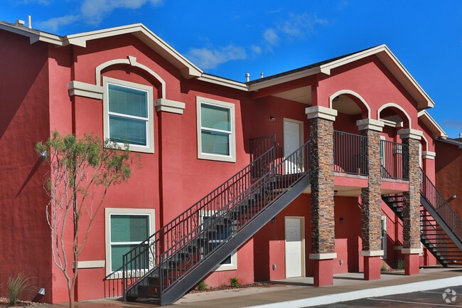
Property Record
8685 N Loop Dr, El Paso, TX 79907

Property Detail
8685 N Loop Dr
A513-999-0010-0100
BLK 1 AMBER SKY ESTATES LOT 1
Apartment
EL PASO
SDC
Texas
B and X Area of moderate flood hazard, usually the area between the limits of the 100-year and 500-year floods.
1
2024
1.87 AC
2025
Colonia del Carmen
004103
El Paso
34,200 SF
El Paso, TX
NEARBY LISTINGS FOR SALE OR LEASE
-
-
View all El Paso listings for sale on LoopNet.com
DEMOGRAPHICS near 8685 N Loop Dr
1 mile
3 mile
5 mile
2025 Total Population
12,763
80,382
210,004
2030 Population
12,796
80,598
211,443
Pop Growth 2025-2030
+ 0.26%
+ 0.27%
+ 0.69%
Average Age
40
40
39
2025 Total Households
4,599
28,111
73,267
HH Growth 2025-2030
+ 0.28%
+ 0.31%
+ 0.69%
Median Household Inc
$41,339
$48,715
$56,944
Avg Household Size
2.70
2.80
2.80
2025 Avg HH Vehicles
2.00
2.00
2.00
Median Home Value
$124,000
$156,261
$179,249
Median Year Built
1981
1982
1984
Nearby Places
Map Layers
Map Styles
 Street
 Aerial
Layers
 Traffic
 Biking
Places
Listings with unknown addresses are not visible on the map
- Restaurants
- Banks
- Shops
- Fitness
- Groceries
PUBLIC TRANSPORTATION
AIRPORT
El Paso International
Drive
Walk
Distance
El Paso International
23 min
11.3 mi
Freight Ports
Port of Corpus Christi
Drive
Walk
Distance
Port of Corpus Christi
669 min
684.2 mi
SALE & LEASE HISTORY
LISTING DATE
SALE/LEASE

May 13, 2023
For Sale
Nearby Properties
Address
Land Use
TOTAL SIZE
Lot Size
Zoning
Address
Land Use
TOTAL SIZE
Lot Size
Zoning
260,501 SF
14.05 AC
A2
Address
Land Use
TOTAL SIZE
Lot Size
Zoning
463,000 SF
24.75 AC
C4
Address
Land Use
TOTAL SIZE
Lot Size
Zoning
89,251 SF
9.39 AC
AM
Address
Land Use
TOTAL SIZE
Lot Size
Zoning
400,929 SF
30.05 AC
Address
Land Use
TOTAL SIZE
Lot Size
Zoning
80,049 SF
8.90 AC
C4
Address
Land Use
TOTAL SIZE
Lot Size
Zoning
235,670 SF
10 AC
A3C
Address
Land Use
TOTAL SIZE
Lot Size
Zoning
652,080 SF
32.64 AC
Address
Land Use
TOTAL SIZE
Lot Size
Zoning
118,114 SF
13.80 AC
C4S
Address
Land Use
TOTAL SIZE
Lot Size
Zoning
656,540 SF
36.94 AC
M1S
Address
Land Use
TOTAL SIZE
Lot Size
Zoning
202,253 SF
10.70 AC
A2
Address
Land Use
TOTAL SIZE
Lot Size
Zoning
166,671 SF
24.61 AC
C4S
Address
Land Use
TOTAL SIZE
Lot Size
Zoning
334,161 SF
20.28 AC
Address
Land Use
TOTAL SIZE
Lot Size
Zoning
230,263 SF
27.25 AC
C3S
Address
Land Use
TOTAL SIZE
Lot Size
Zoning
321,764 SF
18.61 AC
C4
Address
Land Use
TOTAL SIZE
Lot Size
Zoning
209,006 SF
18.18 AC
C4
Address
Land Use
TOTAL SIZE
Lot Size
Zoning
274,580 SF
13.86 AC
C4S
Address
Land Use
TOTAL SIZE
Lot Size
Zoning
230,152 SF
14.09 AC
C4S
Address
Land Use
TOTAL SIZE
Lot Size
Zoning
179,391 SF
8.23 AC
SD
Address
Land Use
TOTAL SIZE
Lot Size
Zoning
192,261 SF
8.07 AC
A3C
Address
Land Use
TOTAL SIZE
Lot Size
Zoning
347,235 SF
33.50 AC
A2
Address
Land Use
TOTAL SIZE
Lot Size
Zoning
111,558 SF
16.25 AC
C4
Address
Land Use
TOTAL SIZE
Lot Size
Zoning
215,378 SF
9.60 AC
M1
Address
Land Use
TOTAL SIZE
Lot Size
Zoning
281,279 SF
14.74 AC
C4
Address
Land Use
TOTAL SIZE
Lot Size
Zoning
377,504 SF
24.32 AC
C4S
Address
Land Use
TOTAL SIZE
Lot Size
Zoning
197,105 SF
15.41 AC
C4S
Address
Land Use
TOTAL SIZE
Lot Size
Zoning
129,165 SF
13.17 AC
A2
Address
Land Use
TOTAL SIZE
Lot Size
Zoning
356,377 SF
25.46 AC
C4S
Address
Land Use
TOTAL SIZE
Lot Size
Zoning
357,090 SF
20 AC
C4
Address
Land Use
TOTAL SIZE
Lot Size
Zoning
300,000 SF
16.93 AC
C4S
Address
Land Use
TOTAL SIZE
Lot Size
Zoning
63,058 SF
21.40 AC
C4
The World's #1 Commercial Real Estate Marketplace
Connect with us
© 2026 CoStar Group
The information above has been obtained from sources believed reliable. While we do not doubt its accuracy we have not verified it and make no guarantee, warranty or representation about it. It is your responsibility to independently confirm its accuracy and completeness. Any projections, opinions, assumptions, or estimates used are for example only and do not represent the current or future performance of the property. The value of this transaction to you depends on tax and other factors which should be evaluated by your tax, financial, and legal advisors. You and your advisors should conduct a careful, independent investigation of the property to determine to your satisfaction the suitability of the property for your needs.