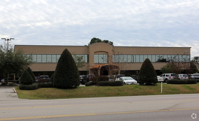
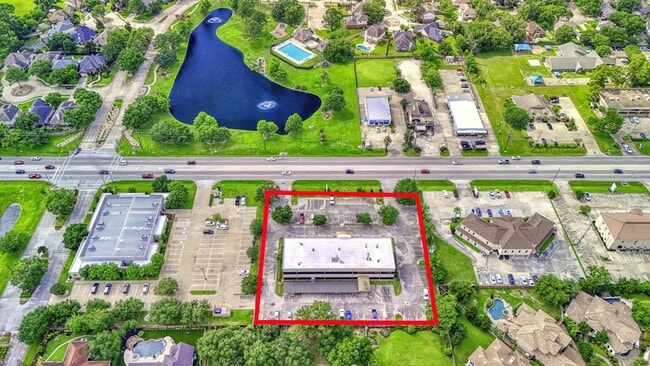
Property Record
8687 Louetta Rd, Spring, TX 77379

Property Detail
8687 Louetta Rd
1216310010024
RES B BLK 1 LAKES OF STERLING GATE
Officebuilding
HARRIS
B and X Area of moderate flood hazard, usually the area between the limits of the 100-year and 500-year floods.
Texas
2024
1.61 AC
2025
FM 1960/Champions
554002
Houston
17,160 SF
Houston-Pasadena-The Woodlands, TX
NEARBY LISTINGS FOR SALE OR LEASE
DEMOGRAPHICS near 8687 Louetta Rd
1 mile
3 mile
5 mile
2025 Total Population
14,729
105,953
302,910
2030 Population
15,531
112,444
321,910
Pop Growth 2025-2030
+ 5.45%
+ 6.13%
+ 6.27%
Average Age
42
40
38
2025 Total Households
5,263
40,123
107,098
HH Growth 2025-2030
+ 5.68%
+ 6.39%
+ 6.48%
Median Household Inc
$117,005
$87,322
$87,606
Avg Household Size
2.80
2.60
2.80
2025 Avg HH Vehicles
2.00
2.00
2.00
Median Home Value
$352,211
$339,327
$318,699
Median Year Built
1988
1992
1996
Nearby Places
Map Layers
Map Styles
 Street
 Aerial
Layers
 Traffic
 Biking
Places
Listings with unknown addresses are not visible on the map
- Restaurants
- Banks
- Shops
- Fitness
- Groceries
PUBLIC TRANSPORTATION
AIRPORT
George Bush Intcntl/Houston
Drive
Walk
Distance
George Bush Intcntl/Houston
29 min
19.2 mi
William P Hobby
Drive
Walk
Distance
William P Hobby
57 min
34.8 mi
Freight Ports
Port of Houston
Drive
Walk
Distance
Port of Houston
49 min
30.3 mi
SALE & LEASE HISTORY
LISTING DATE
SALE/LEASE

Sep 25, 2016
For Lease
May 17, 2019
For Lease
Jun 02, 2025
For Lease
Nearby Properties
Address
Land Use
TOTAL SIZE
Lot Size
Zoning
Address
Land Use
TOTAL SIZE
Lot Size
Zoning
1,648,539 SF
28.70 AC
Address
Land Use
TOTAL SIZE
Lot Size
Zoning
339,067 SF
34.40 AC
Address
Land Use
TOTAL SIZE
Lot Size
Zoning
427,317 SF
14.16 AC
Address
Land Use
TOTAL SIZE
Lot Size
Zoning
1,073,104 SF
4.74 AC
Address
Land Use
TOTAL SIZE
Lot Size
Zoning
227,400 SF
2.77 AC
Address
Land Use
TOTAL SIZE
Lot Size
Zoning
386,754 SF
17.99 AC
Address
Land Use
TOTAL SIZE
Lot Size
Zoning
341,895 SF
17.53 AC
Address
Land Use
TOTAL SIZE
Lot Size
Zoning
507,035 SF
24.90 AC
Address
Land Use
TOTAL SIZE
Lot Size
Zoning
263,640 SF
36.62 AC
Address
Land Use
TOTAL SIZE
Lot Size
Zoning
402,504 SF
31.93 AC
Address
Land Use
TOTAL SIZE
Lot Size
Zoning
551,524 SF
10.06 AC
Address
Land Use
TOTAL SIZE
Lot Size
Zoning
339,477 SF
13.54 AC
Address
Land Use
TOTAL SIZE
Lot Size
Zoning
267,094 SF
14.76 AC
Address
Land Use
TOTAL SIZE
Lot Size
Zoning
486,739 SF
19.92 AC
Address
Land Use
TOTAL SIZE
Lot Size
Zoning
262,163 SF
8.63 AC
Address
Land Use
TOTAL SIZE
Lot Size
Zoning
405,225 SF
18.34 AC
Address
Land Use
TOTAL SIZE
Lot Size
Zoning
423,472 SF
28.91 AC
Address
Land Use
TOTAL SIZE
Lot Size
Zoning
256,761 SF
8.78 AC
Address
Land Use
TOTAL SIZE
Lot Size
Zoning
267,082 SF
11.13 AC
Address
Land Use
TOTAL SIZE
Lot Size
Zoning
433,984 SF
17.82 AC
Address
Land Use
TOTAL SIZE
Lot Size
Zoning
260,253 SF
7.46 AC
Address
Land Use
TOTAL SIZE
Lot Size
Zoning
377,188 SF
16.80 AC
Address
Land Use
TOTAL SIZE
Lot Size
Zoning
371,761 SF
12.71 AC
Address
Land Use
TOTAL SIZE
Lot Size
Zoning
181,542 SF
8 AC
Address
Land Use
TOTAL SIZE
Lot Size
Zoning
308,141 SF
17.64 AC
Address
Land Use
TOTAL SIZE
Lot Size
Zoning
335,954 SF
35.27 AC
Address
Land Use
TOTAL SIZE
Lot Size
Zoning
80,004 SF
4.41 AC
Address
Land Use
TOTAL SIZE
Lot Size
Zoning
300,080 SF
13.86 AC
Address
Land Use
TOTAL SIZE
Lot Size
Zoning
348,658 SF
16.72 AC
Address
Land Use
TOTAL SIZE
Lot Size
Zoning
148,450 SF
18.26 AC
The World's #1 Commercial Real Estate Marketplace
Connect with us
© 2026 CoStar Group
The information above has been obtained from sources believed reliable. While we do not doubt its accuracy we have not verified it and make no guarantee, warranty or representation about it. It is your responsibility to independently confirm its accuracy and completeness. Any projections, opinions, assumptions, or estimates used are for example only and do not represent the current or future performance of the property. The value of this transaction to you depends on tax and other factors which should be evaluated by your tax, financial, and legal advisors. You and your advisors should conduct a careful, independent investigation of the property to determine to your satisfaction the suitability of the property for your needs.