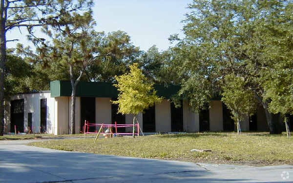
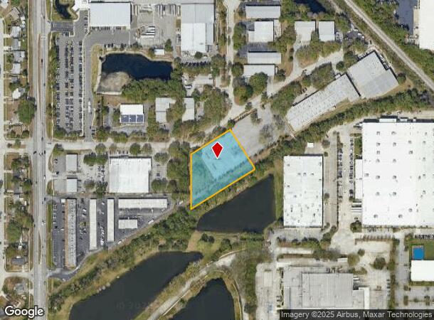
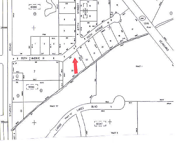
Property Record
8720 115Th Ave, Largo, FL 33773
NEARBY LISTINGS FOR SALE OR LEASE
-
-
-
-
-
-
-
No Photo
-
View all Largo listings for sale on LoopNet.com
Property Detail
8720 115Th Ave
Tampa-St. Petersburg-Clearwater, FL
Oakwoods Industrial Center
13-30-15-63701-000-0230
OAKWOODS INDUSTRIAL CENTER LOT 23
Industrialacreage
Pinellas
X
Florida
12103C0119H
23
2024
1.54 AC
2025
South Pinellas
025011
Tampa/St Petersburg
7,800 SF
DEMOGRAPHICS near 8720 115Th Ave
1 Mile
3 Mile
5 Mile
2024 Total Population
7,108
103,399
274,781
2029 Population
7,019
103,644
275,395
Pop Growth 2024-2029
(1.25%)
+ 0.24%
+ 0.22%
Average Age
46
47
46
2024 Total Households
2,794
47,802
124,234
HH Growth 2024-2029
(1.61%)
+ 0.13%
+ 0.12%
Median Household Inc
$93,110
$57,785
$57,904
Avg Household Size
2.40
2.10
2.10
2024 Avg HH Vehicles
2.00
2.00
2.00
Median Home Value
$341,613
$213,889
$246,062
Median Year Built
1983
1977
1975
Nearby Places
- Restaurants
- Banks
- Shops
- Fitness
- Groceries
PUBLIC TRANSPORTATION
AIRPORT
St Pete-Clearwater International
DRIVE
WALK
Distance
St Pete-Clearwater International
15 min
7.2 mi
Tampa International
DRIVE
WALK
Distance
Tampa International
32 min
20.1 mi
Sarasota/Bradenton International
DRIVE
WALK
Distance
Sarasota/Bradenton International
68 min
44.7 mi
Freight Ports
Port of Tampa Bay
DRIVE
WALK
Distance
Port of Tampa Bay
42 min
25.5 mi
Nearby Properties
Address
Land Use
TOTAL SIZE
Lot Size
Zoning
Address
Land Use
TOTAL SIZE
Lot Size
Zoning
537,958 SF
41.61 AC
C2
Address
Land Use
TOTAL SIZE
Lot Size
Zoning
459,848 SF
19.74 AC
R6
Address
Land Use
TOTAL SIZE
Lot Size
Zoning
520,871 SF
29 AC
R6
Address
Land Use
TOTAL SIZE
Lot Size
Zoning
367,081 SF
13.80 AC
Address
Land Use
TOTAL SIZE
Lot Size
Zoning
382,389 SF
13.62 AC
Address
Land Use
TOTAL SIZE
Lot Size
Zoning
223,748 SF
100.32 AC
R3
Address
Land Use
TOTAL SIZE
Lot Size
Zoning
333,425 SF
33.66 AC
Address
Land Use
TOTAL SIZE
Lot Size
Zoning
588,657 SF
33 AC
Address
Land Use
TOTAL SIZE
Lot Size
Zoning
384,124 SF
25.78 AC
C3
Address
Land Use
TOTAL SIZE
Lot Size
Zoning
266,396 SF
23.18 AC
Address
Land Use
TOTAL SIZE
Lot Size
Zoning
227,858 SF
64.31 AC
AE
Address
Land Use
TOTAL SIZE
Lot Size
Zoning
294,478 SF
44.79 AC
M1
Address
Land Use
TOTAL SIZE
Lot Size
Zoning
206,685 SF
16.75 AC
RPD5
Address
Land Use
TOTAL SIZE
Lot Size
Zoning
582,271 SF
17.14 AC
Address
Land Use
TOTAL SIZE
Lot Size
Zoning
241,547 SF
9.27 AC
Address
Land Use
TOTAL SIZE
Lot Size
Zoning
249,699 SF
15 AC
Address
Land Use
TOTAL SIZE
Lot Size
Zoning
10,474 SF
660.47 AC
R3
Address
Land Use
TOTAL SIZE
Lot Size
Zoning
280,129 SF
Address
Land Use
TOTAL SIZE
Lot Size
Zoning
319,725 SF
9.14 AC
Address
Land Use
TOTAL SIZE
Lot Size
Zoning
84,057 SF
34.26 AC
Address
Land Use
TOTAL SIZE
Lot Size
Zoning
261,486 SF
30.21 AC
RPD20
Address
Land Use
TOTAL SIZE
Lot Size
Zoning
176,716 SF
14.20 AC
Address
Land Use
TOTAL SIZE
Lot Size
Zoning
194,610 SF
36.55 AC
R3
Address
Land Use
TOTAL SIZE
Lot Size
Zoning
129,600 SF
7.09 AC
Address
Land Use
TOTAL SIZE
Lot Size
Zoning
174,082 SF
17.08 AC
C2
Address
Land Use
TOTAL SIZE
Lot Size
Zoning
211,684 SF
14.48 AC
M1
Address
Land Use
TOTAL SIZE
Lot Size
Zoning
194,748 SF
12.69 AC
M1
Address
Land Use
TOTAL SIZE
Lot Size
Zoning
157,769 SF
4.47 AC
Address
Land Use
TOTAL SIZE
Lot Size
Zoning
687,675 SF
67.89 AC
M1
Address
Land Use
TOTAL SIZE
Lot Size
Zoning
159,667 SF
20 AC
AE
The World's #1 Commercial Real Estate Marketplace
Connect with us
© 2025 CoStar Group
The information above has been obtained from sources believed reliable. While we do not doubt its accuracy we have not verified it and make no guarantee, warranty or representation about it. It is your responsibility to independently confirm its accuracy and completeness. Any projections, opinions, assumptions, or estimates used are for example only and do not represent the current or future performance of the property. The value of this transaction to you depends on tax and other factors which should be evaluated by your tax, financial, and legal advisors. You and your advisors should conduct a careful, independent investigation of the property to determine to your satisfaction the suitability of the property for your needs.