Property Record
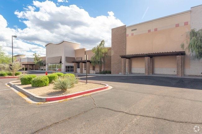
8688 E Raintree Dr, Scottsdale, AZ 85260

Property Detail
8688 E Raintree Dr
215-52-034W
NORTHSIGHT CROSSING PROPERTY AMD LOTS 1 AND 6 MLD MCR 1443-45
Apartment
Maricopa
PCP
Arizona
C and X Area of minimal flood hazard, usually depicted on FIRMs as above the 500-year flood level.
3
2025
5.56 AC
2025
North Scottsdale
216816
Phoenix
542,795 SF
Phoenix-Mesa-Chandler, AZ
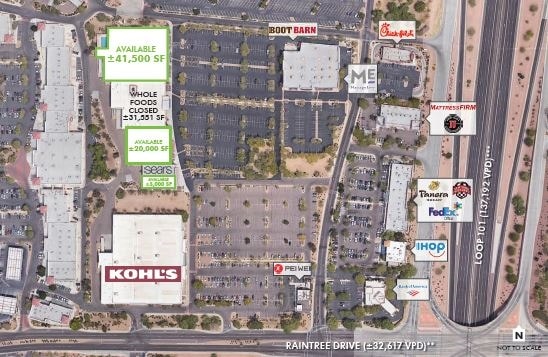
NEARBY LISTINGS FOR SALE OR LEASE
DEMOGRAPHICS near 8688 E Raintree Dr
1 mile
3 mile
5 mile
2025 Total Population
7,479
78,155
180,027
2030 Population
7,838
82,706
189,701
Pop Growth 2025-2030
+ 4.80%
+ 5.82%
+ 5.37%
Average Age
42
44
45
2025 Total Households
3,508
35,644
80,473
HH Growth 2025-2030
+ 4.79%
+ 6.13%
+ 5.66%
Median Household Inc
$96,174
$115,927
$119,132
Avg Household Size
2.10
2.10
2.20
2025 Avg HH Vehicles
2.00
2.00
2.00
Median Home Value
$675,230
$796,285
$822,083
Median Year Built
1993
1995
1992
Nearby Places
Map Layers
Map Styles
 Street
 Aerial
Layers
 Traffic
 Biking
Places
Listings with unknown addresses are not visible on the map
- Restaurants
- Banks
- Shops
- Fitness
- Groceries
PUBLIC TRANSPORTATION
AIRPORT
Phoenix Sky Harbor International
Drive
Walk
Distance
Phoenix Sky Harbor International
23 min
20.5 mi
Freight Ports
Port of San Diego
Drive
Walk
Distance
Port of San Diego
1 min
311.0 mi
SALE & LEASE HISTORY
LISTING DATE
SALE/LEASE

Nov 13, 2017
For Lease
Jun 14, 2017
For Lease
Jul 28, 2017
For Lease
Nearby Properties
Address
Land Use
TOTAL SIZE
Lot Size
Zoning
Address
Land Use
TOTAL SIZE
Lot Size
Zoning
20.98 AC
Address
Land Use
TOTAL SIZE
Lot Size
Zoning
1,293,284 SF
14.50 AC
C-R
Address
Land Use
TOTAL SIZE
Lot Size
Zoning
1,479,005 SF
12.55 AC
PC
Address
Land Use
TOTAL SIZE
Lot Size
Zoning
3.15 AC
I-P
Address
Land Use
TOTAL SIZE
Lot Size
Zoning
667,688 SF
277.21 AC
Address
Land Use
TOTAL SIZE
Lot Size
Zoning
694,644 SF
34.41 AC
C-C
Address
Land Use
TOTAL SIZE
Lot Size
Zoning
500,010 SF
4.52 AC
PF
Address
Land Use
TOTAL SIZE
Lot Size
Zoning
794,304 SF
14.59 AC
WTP
Address
Land Use
TOTAL SIZE
Lot Size
Zoning
6.71 AC
PAD
Address
Land Use
TOTAL SIZE
Lot Size
Zoning
762,044 SF
16.66 AC
I1
Address
Land Use
TOTAL SIZE
Lot Size
Zoning
7,803 SF
2.31 AC
I-P
Address
Land Use
TOTAL SIZE
Lot Size
Zoning
368,657 SF
40.11 AC
Address
Land Use
TOTAL SIZE
Lot Size
Zoning
514,088 SF
6.70 AC
PAD
Address
Land Use
TOTAL SIZE
Lot Size
Zoning
533,288 SF
18.61 AC
I-P
Address
Land Use
TOTAL SIZE
Lot Size
Zoning
428,891 SF
6.48 AC
PAD
Address
Land Use
TOTAL SIZE
Lot Size
Zoning
707,542 SF
28.49 AC
R-3A
Address
Land Use
TOTAL SIZE
Lot Size
Zoning
421,002 SF
23.48 AC
Address
Land Use
TOTAL SIZE
Lot Size
Zoning
824,672 SF
11.52 AC
Address
Land Use
TOTAL SIZE
Lot Size
Zoning
884,258 SF
30.63 AC
PCD
Address
Land Use
TOTAL SIZE
Lot Size
Zoning
90.73 AC
O-S
Address
Land Use
TOTAL SIZE
Lot Size
Zoning
380,106 SF
38.10 AC
C-T
Address
Land Use
TOTAL SIZE
Lot Size
Zoning
497,704 SF
6.77 AC
Address
Land Use
TOTAL SIZE
Lot Size
Zoning
9,232 SF
4.07 AC
R-35
Address
Land Use
TOTAL SIZE
Lot Size
Zoning
355,757 SF
32.44 AC
C-R
Address
Land Use
TOTAL SIZE
Lot Size
Zoning
337,668 SF
8.14 AC
PAD
Address
Land Use
TOTAL SIZE
Lot Size
Zoning
417,831 SF
2.68 AC
C-R
The World's #1 Commercial Real Estate Marketplace
Connect with us
© 2026 CoStar Group
The information above has been obtained from sources believed reliable. While we do not doubt its accuracy we have not verified it and make no guarantee, warranty or representation about it. It is your responsibility to independently confirm its accuracy and completeness. Any projections, opinions, assumptions, or estimates used are for example only and do not represent the current or future performance of the property. The value of this transaction to you depends on tax and other factors which should be evaluated by your tax, financial, and legal advisors. You and your advisors should conduct a careful, independent investigation of the property to determine to your satisfaction the suitability of the property for your needs.