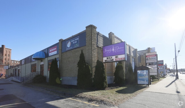
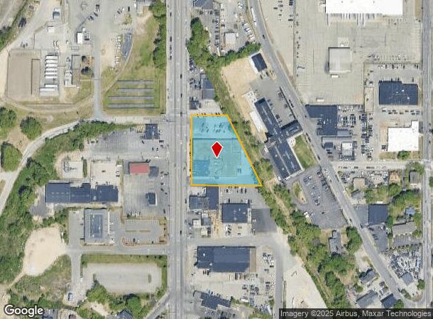
Property Record
87 Elm St, Manchester, NH 03101
Current Lease Availabilities
NEARBY LISTINGS FOR SALE OR LEASE
Property Detail
87 Elm St
MNCH-000457-000000-000003
Hillsborough
Departmentstore
New Hampshire
X
3
33011C0377D
1.31 AC
2024
Hillsborough
2024
Boston
001900
Manchester-Nashua, NH
32,970 SF
DEMOGRAPHICS near 87 Elm St
1 Mile
3 Mile
5 Mile
2024 Total Population
24,827
104,407
141,255
2029 Population
25,022
105,777
143,782
Pop Growth 2024-2029
+ 0.79%
+ 1.31%
+ 1.79%
Average Age
37
40
40
2024 Total Households
10,279
43,813
57,983
HH Growth 2024-2029
+ 0.80%
+ 1.37%
+ 1.85%
Median Household Inc
$56,510
$70,552
$76,360
Avg Household Size
2.30
2.20
2.30
2024 Avg HH Vehicles
1.00
2.00
2.00
Median Home Value
$256,630
$302,404
$325,373
Median Year Built
1949
1959
1970
Nearby Places
Map Layers
Map Styles
 Street
 Aerial
- Restaurants
- Banks
- Shops
- Fitness
- Groceries
PUBLIC TRANSPORTATION
AIRPORT
Manchester Boston Regional
DRIVE
WALK
Distance
Manchester Boston Regional
14 min
5.1 mi
Portsmouth International at Pease
DRIVE
WALK
Distance
Portsmouth International at Pease
65 min
42.4 mi
Nearby Properties
Address
Land Use
TOTAL SIZE
Lot Size
Zoning
Address
Land Use
TOTAL SIZE
Lot Size
Zoning
446,957 SF
24.16 AC
Address
Land Use
TOTAL SIZE
Lot Size
Zoning
383,493 SF
34.51 AC
Address
Land Use
TOTAL SIZE
Lot Size
Zoning
6,830 SF
17.24 AC
Address
Land Use
TOTAL SIZE
Lot Size
Zoning
60,000 SF
144.50 AC
R2
Address
Land Use
TOTAL SIZE
Lot Size
Zoning
256,041 SF
6.69 AC
Address
Land Use
TOTAL SIZE
Lot Size
Zoning
135,686 SF
30.23 AC
Address
Land Use
TOTAL SIZE
Lot Size
Zoning
29,803 SF
31.46 AC
PZ
Address
Land Use
TOTAL SIZE
Lot Size
Zoning
3,748 SF
14.69 AC
Address
Land Use
TOTAL SIZE
Lot Size
Zoning
250,905 SF
1.16 AC
Address
Land Use
TOTAL SIZE
Lot Size
Zoning
217,697 SF
43.25 AC
Address
Land Use
TOTAL SIZE
Lot Size
Zoning
229,089 SF
3.58 AC
Address
Land Use
TOTAL SIZE
Lot Size
Zoning
135,879 SF
2.36 AC
Address
Land Use
TOTAL SIZE
Lot Size
Zoning
26,125 SF
150.66 AC
Address
Land Use
TOTAL SIZE
Lot Size
Zoning
43,576 SF
R2
Address
Land Use
TOTAL SIZE
Lot Size
Zoning
16,464 SF
15.19 AC
Address
Land Use
TOTAL SIZE
Lot Size
Zoning
398,130 SF
1.68 AC
Address
Land Use
TOTAL SIZE
Lot Size
Zoning
22,101 SF
8.33 AC
Address
Land Use
TOTAL SIZE
Lot Size
Zoning
49,788 SF
34.73 AC
Address
Land Use
TOTAL SIZE
Lot Size
Zoning
221,144 SF
3.77 AC
Address
Land Use
TOTAL SIZE
Lot Size
Zoning
237,634 SF
5.39 AC
Address
Land Use
TOTAL SIZE
Lot Size
Zoning
24,064 SF
19.44 AC
Address
Land Use
TOTAL SIZE
Lot Size
Zoning
16,000 SF
58.17 AC
Address
Land Use
TOTAL SIZE
Lot Size
Zoning
207,701 SF
4.16 AC
Address
Land Use
TOTAL SIZE
Lot Size
Zoning
44,878 SF
12.89 AC
CO
Address
Land Use
TOTAL SIZE
Lot Size
Zoning
116,763 SF
7 AC
PZ
Address
Land Use
TOTAL SIZE
Lot Size
Zoning
181,610 SF
0.58 AC
Address
Land Use
TOTAL SIZE
Lot Size
Zoning
2,656 SF
16.01 AC
Address
Land Use
TOTAL SIZE
Lot Size
Zoning
139,616 SF
18.47 AC
PZ
Address
Land Use
TOTAL SIZE
Lot Size
Zoning
165,000 SF
3.38 AC
Address
Land Use
TOTAL SIZE
Lot Size
Zoning
180,474 SF
18.60 AC
The World's #1 Commercial Real Estate Marketplace
Connect with us
© 2026 CoStar Group
The information above has been obtained from sources believed reliable. While we do not doubt its accuracy we have not verified it and make no guarantee, warranty or representation about it. It is your responsibility to independently confirm its accuracy and completeness. Any projections, opinions, assumptions, or estimates used are for example only and do not represent the current or future performance of the property. The value of this transaction to you depends on tax and other factors which should be evaluated by your tax, financial, and legal advisors. You and your advisors should conduct a careful, independent investigation of the property to determine to your satisfaction the suitability of the property for your needs.